
NWMSGuy
Member
I would think portions of East AR are also in play.West. Middle tenn. northern ms. North half ala... look ominous
Follow along with the video below to see how to install our site as a web app on your home screen.
Note: This feature may not be available in some browsers.
I would think portions of East AR are also in play.West. Middle tenn. northern ms. North half ala... look ominous
Yes... very could b before noonish that area MondayI would think portions of East AR are also in play.
GFS is definitely faster than last night's run that got everyone's attention too. Last night's run had the surface low back near SGF with the cold front on the AR/OK line at 6Z Tuesday. This 12Z run has the surface low in western IL with the cold front coming through Jonesboro, AR at 6Z Tuesday.
Yes... very could b before noonish that area Monday
I am curious to your thoughts on this as well Fred..Fred,
I know that we are several days out from this event; but if things line up the way they are looking now; could you see the SPC going with a High Risk somewhere over North Alabama, North Mississippi, or Southern Tennessee?
Fred,
I know that we are several days out from this event; but if things line up the way they are looking now; could you see the SPC going with a High Risk somewhere over North Alabama, North Mississippi, or Southern Tennessee?
I think it's less impossible than it is with most systems we talk about here, and I think just getting the timing for Alabama out of that "straddle zone" between what SPC uses for "Monday" and "Tuesday" and fit the timing firmly into "Monday" for them, alone, would increase the chances of that happening. That "straddle" is the only reason why Alabama is not sitting in the 30% risk already. They made it clear in the discussion that the *significant* risk would extend into Tuesday (and Tuesday to them starts at 12Z Tuesday).
Fred, I am in southern Middle TN.. do you feel the risk is as high here as in AL?
I found this:Does anyone have the 500mb chart from Nov.10 2002? I was trying to find one but couldn't.
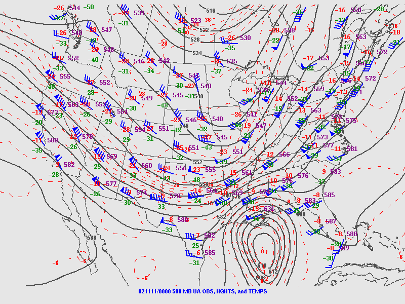

So what effect might that have?The trough for this event is a little sharper compared to 2002.
So what effect might that have?
Also you could argue that it could be slightly colder aloft...but there could be other unknown variables to compensate.Stronger wind fields, stronger pressure falls, the potential for the surface low to be closer (the sfc low with that event actually moved into southern Canada that morning and we just had pressure falls down the cold front to back the low-level winds).....
So basically it’s making possibly more volitileAlso you could argue that it could be slightly colder aloft...but there could be other unknown variables to compensate.