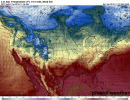
• Welcome to TalkWeather!
    We see you lurking around TalkWeather! Take the extra step and join us today to view attachments, see less ads and maybe even join the discussion.
    CLICK TO JOIN TALKWEATHER
  • April 2024 Weather Video of the Month
    Post your nominations now!

Severe WX Severe Weather Threat 11/5-11/7

amp1998

Member
Messages
59
Reaction score
45
Location
Alabama
Is this what you are looking for?
Does anybody have a good temp and dew point map for Tuesday?
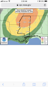
sfctd_b.conus.png
 

Attachments

  • sfct_b.conus.png
    sfct_b.conus.png
    811.3 KB · Views: 0

Fred Gossage

Member
Meteorologist
PerryW Project Supporter
Messages
663
Reaction score
2,619
Location
Florence, AL
Perfect. Thank you.

Do the temps not seem a little cool for a severe weather outbreak north of about Bham. Looks like it will be about 70 in HSV, or is that underdone?
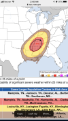
If the NAM and GFS were right about having temps as cool as they have them overnight with every other time they have them during a severe weather threat, there would never be any tornadoes in history past 5:00pm. That's all I will say...
 

Fred Gossage

Member
Meteorologist
PerryW Project Supporter
Messages
663
Reaction score
2,619
Location
Florence, AL
MOS/MEX guidance has highs of 74-78 for HSV and MSL Monday afternoon. Those are often much closer to reality in situations like this than the map-based operational models that always magically decouple the boundary layer right at sunset because of their parameterization schemes relation to solar radiation and such.
 
Messages
1,079
Reaction score
1,328
Location
jackson tennessee
Special Affiliations
  1. SKYWARN® Volunteer
15 minutes away from 3 day outlook from spc... 0z euro wanting slow down bit vs 12z. Interesting seems trying develop another slp back nw ark... talking bout backing winds ... ouch
 

Fred Gossage

Member
Meteorologist
PerryW Project Supporter
Messages
663
Reaction score
2,619
Location
Florence, AL
Just now noticed. Wow... think I have never seen that on day 3. Correct me if I’m wrong

We've seen up to Moderate Risks on the Day 3 more than a few times over the years, including over your specific area....
 

Kory

Member
Messages
4,928
Reaction score
2,119
Location
Tuscaloosa, Alabama
Can't say I'm particularly impressed with the 12z NAM. The evolution of the shortwave kicking NE and leaving behind rising heights is too reminiscent of 12/23/15. Overall, the evolution is very similar to that event in my opinion. Granted, that was still a localized significant event, but spatially, that it was a bust.

I am NOT saying that about this situation. I'm just comparing the overall evolution of the 500mb trough.
 

rolltide_130

Member
Messages
828
Reaction score
378
Location
Harvest, Alabama
Special Affiliations
Can't say I'm particularly impressed with the 12z NAM. The evolution of the shortwave kicking NE and leaving behind rising heights is too reminiscent of 12/23/15. Overall, the evolution is very similar to that event in my opinion. Granted, that was still a localized significant event, but spatially, that it was a bust.

I am NOT saying that about this situation. I'm just comparing the overall evolution of the 500mb trough.

It also had a horrible handle on the sfc low. I think it's a bad run. The 3km NAM also limits the threat to South AL? Very odd.
 
Back
Top