stormcentral
Member

Follow along with the video below to see how to install our site as a web app on your home screen.
Note: This feature may not be available in some browsers.

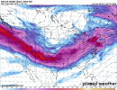
Some of the overnight models were less than impressive. Going to have to see if the 12z suites correct themselves or if we are actually losing this system.
I’m sorry, but that’s not true.
Some of the overnight models were less than impressive. Going to have to see if the 12z suites correct themselves or if we are actually losing this system.
")
I'M GOOD WITH IT!!almost like it is trying to avoid Alabama..
SPC introduced strong tor wording but did trim the enhanced northwest. Takes more of central AL out of the greatest risk.
It could, but BMX's discussion says that is somewhat unlikely.Although that could be changed again by tomorrow morning.
Perhaps it was just a mistake?SPC added the significant tornado area back. I wonder why they removed it to begin with..