• Welcome to TalkWeather!
    We see you lurking around TalkWeather! Take the extra step and join us today to view attachments, see less ads and maybe even join the discussion.
    CLICK TO JOIN TALKWEATHER

Severe WX Severe Weather Event April 13-14, 2019

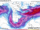
00z Euro holds serve with a very dangerous looking setup from early afternoon Saturday through Sunday. There are some notable similarities here to the Nov 21-23, 1992 event across this same region, which was, of course, a very significant tornado event with a large after-dark component.

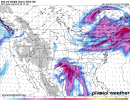
I don't currently see any reason why storms won't keep raging through the night here, and they look like they could very well stay discrete/semi-discrete.
 
The 1992 analog is a very good synoptic one, except for one difference. I think the higher-end stuff would start north/northeast of where it did that event because of the low-level jet waiting until the MS River to really ramp up. I think the tornado threat starts out in Texas, and the higher-end threat starts in northeast LA and southeast AR... but this feels like it's pointed at MS/AL/TN/eventually GA.
 
day4prob.gif
 
I'd suspect if the timing of the system wasn't falling across the SPC cut off between outlooks, we'd have a 30% look extending into AL. I don't see us escaping at least a moderate risk out of this. Again, I've yet to find a significant mitigating factor for us.

Euro/UKMET have plenty of convection across the free warm sector beginning earlier Saturday night.
 
PDS TOR soundings abound across E. TX and most of LA on both NAM and GFS 06Z runs valid for 18Z Saturday, which as as far out as they go. No reason to think 12Z won't be similar.
NAM is pretty big at 18z indeed, SREF already popping a 60% contour on frame 30. 4/2/17 comes to mind thinking about this setup. We escaped substantial damage that day, but there were a lot of serious signatures on radar with debris and a few tornado emergencies. This time however, we're looking at a more widespread threat that will probably continue into the overnight hours in MS/AL, something that didn't occur with 4/2/17. Also 4/2/17 had a messy warm sector, so that'll be the big question here as we approach the setup.
 
NAM is pretty big at 18z indeed, SREF already popping a 60% contour on frame 30. 4/2/17 comes to mind thinking about this setup. We escaped substantial damage that day, but there were a lot of serious signatures on radar with debris and a few tornado emergencies. This time however, we're looking at a more widespread threat that will probably continue into the overnight hours in MS/AL, something that didn't occur with 4/2/17. Also 4/2/17 had a messy warm sector, so that'll be the big question here as we approach the setup.
Looks like a large EML will slide in ahead of the system capping most of the warm sector until later in the evening and overnight. And by that time, deep layer shear would probably keep storms quite organized, reducing junk convection.
 
NAM is pretty big at 18z indeed, SREF already popping a 60% contour on frame 30. 4/2/17 comes to mind thinking about this setup. We escaped substantial damage that day, but there were a lot of serious signatures on radar with debris and a few tornado emergencies. This time however, we're looking at a more widespread threat that will probably continue into the overnight hours in MS/AL, something that didn't occur with 4/2/17. Also 4/2/17 had a messy warm sector, so that'll be the big question here as we approach the setup.

That's the day I just had in mind as one that didn't turn out quite as dangerous as first thought...it too was being compared to the November 1992 outbreak in the days leading up to it.
 
Goodness gracious the soundings on the 12z NAM for Saturday in E TX and LA are insane. Long range NAM, but not really surprising given what the GFS/Euro have been putting out for days now.
 
Any thoughts on the Memphis area with the low tracking just to the west or right overhead?
Not going pull the best dynamics in with warm front ... before frontal boundary passes ... ton heavy rain n some wind ... next weeks system different tune... but on this threat ... not seeing any red alert for now
 
I noticed that the NAM pops a couple of Palm Sunday 1994 analogs in LA at 18z on Saturday. Yikes.
I noticed that too. Don’t like to read anything into this by means of comparison, but again, I noticed too.
 
SPC has a 15% area on D5 (Sunday) for a chunk of Georgia, but the GFS doesn't have a lot of good ingredients showing. What am I missing? Is that just too far out for the GFS?
 
Back
Top