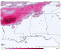
Ice totals at the end of the nam run along with the current radar at the end. With lots more frozen rain.
Big event incoming..?

Big event incoming..?
Follow along with the video below to see how to install our site as a web app on your home screen.
Note: This feature may not be available in some browsers.
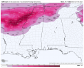
I guess the Canadians know how to forecast the cold weather lol. The cold bias helps in this case I think00z and 12z Canadian. Remaining consistent for the last 15 runs. Kinda creepy and interesting how consistent it's been.

'94 is all I could findWhens the last time around Memphis and west Tennessee has had around a inch of freezing rain?
From what I can find, Memphis saw around 2 inches of ice during the Great Storm of 1951. The other one is the 94 storm.Whens the last time around Memphis and west Tennessee has had around a inch of freezing rain?
.png")

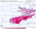
Isn't this in your neck of the woods? What part of Mississippi do you live in?View attachment 17329
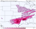
00z Canadian RDPS is absolutely terrifying. Not gonna lie starting to get nervous about this one.