
IcemanRetitled. It's time to build a snowman.
Navigation
Install the app
How to install the app on iOS
Follow along with the video below to see how to install our site as a web app on your home screen.
Note: This feature may not be available in some browsers.
More options
-
Welcome to TalkWeather! We see you lurking around TalkWeather! Take the extra step and join us today to view attachments, see less ads and maybe even join the discussion. CLICK TO JOIN TALKWEATHER
You are using an out of date browser. It may not display this or other websites correctly.
You should upgrade or use an alternative browser.
You should upgrade or use an alternative browser.
Winter Weather/Ice Storm Threat January 30 - February 3, 2023 - Ice Ice Baby
- Thread starter Lake Martin EF4
- Start date
aujerm
Member
Really hoping north Georgia gets a few inches of snow out of this one.Retitled. It's time to build a snowman.
Austin Dawg
Member
Iceman
Attachments

Timhsv
Member

The latest GDPS ( Canadian ) supporting the other models for a possible major icing event by Wednesday of next week along, either side of I-40. Nasty scenario setting up with over running. I hate ice.....
Last edited:
Seems like tennessee and the Tennessee valley (extreme north Alabama and Mississippi) will have a few chances for freezing rain/sleet/snow.
It'll be important to watch the surface low and it's position for a possibly decent snow in portions of the deep south.
It'll be important to watch the surface low and it's position for a possibly decent snow in portions of the deep south.
Mess around and may have a couple inches of snow in central Alabama around the time frame of next weekend or Thursday or Friday before the weekend. If some cards fall into place. With the last event switching from snow to severe to snow and then coastal tornadoes. I'm hesitant on locking in on a potential wintery precip solution in central Alabama or heck most of the deep south.
The Canadian continues to be consistent with being further south.
Attachments
GA Stormchaser
Member
- Messages
- 160
- Reaction score
- 260
- Location
- Flowery Branch, GA
- HAM Callsign
- KM4JKH
- Special Affiliations
- SKYWARN® Volunteer
SPC mentions a potential severe weather event Thu or Fri in the southeast. Guess the winter stuff is on the back side
Sent from my iPhone using Tapatalk
Sent from my iPhone using Tapatalk
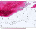
Woah. Memphis may get hammered by ice. Took a look at the latest nam run. Makes you wanna bite nails
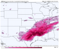
I'd say confidence in a nasty ice event is growing from a corridor of Memphis to Nashville, oof not looking good at all. This could possibly cripple a couple major cities depending on how this plays out ... 

Woah. Memphis may get hammered by ice. Took a look at the latest nam run. Makes you wanna bite nails

That's MAJOR.and to think it'll probably accumulate more after that, because the Nam can't go any further to show accumlations.
Very key to note, often dense artic air can't be handled well by models so it may be a tad underestimating the dense air we will see. It may have gotten better over the years.
Which is why I tend to believe the Canadian model with the further south aspect on the freezing rain.That's MAJOR.and to think it'll probably accumulate more after that, because the Nam can't go any further to show accumlations.
Very key to note, often dense artic air can't be handled well by models so it may be a tad underestimating the dense air we will see. It may have gotten better over the years.
Interesting point you make there. I think the Canadian has a cold bias like the FV3 has a warm bias. So it may be smart to pay attention to the Canadian somwWhich is why I tend to believe the Canadian model with the further south aspect on the freezing rain.
I'm kinda. Curious as to how much freezing rain opportunities Tennessee will have, there's a few events coming up that could trend to more ice; would it be far fetched that this could be a disaster..? Especially if the Canadian was right all along? Sending best of wishes to the Memphis NWS office its going to be a lot of hard forecasts coming soon. Winter weather is always super hard in forecasting; I wish I knew more but all I can look at is raw model data and it doesn't look good for Memphis.
A crippling sequence of icy events could be on the horizon.
A crippling sequence of icy events could be on the horizon.
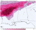
Memphis forecast discussion 20% confidence in accumlatuons of a quarter of inch of ice. 
Not trying to overhype this, if Im coming across this way but in all seriousness a potentially dangerous freezing rain event could happen. A quarter of a inch is a decent bit. I'll put this graphic here. .png")
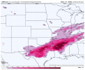
Good grief man, .5 inches of freezing rain.
Looks to be that the 12,z nam is heading in the direction of over 1/2 inch with incredible freezing rain rates at the end of the run.
Forecasts still on course with a major Ice event for Tennessee and the Tennessee valley
Forecasts still on course with a major Ice event for Tennessee and the Tennessee valley