• Welcome to TalkWeather!
    We see you lurking around TalkWeather! Take the extra step and join us today to view attachments, see less ads and maybe even join the discussion.
    CLICK TO JOIN TALKWEATHER
Logo 468x120

YT_candidate

Member
Messages
5
Reaction score
10
Location
Texas
I'll take my words back cuz now it seems just as strong as wilkin even stronger judging from the ground scouring.
I would be inclined to agree, that central cutting line is something else. It appears I may have been incorrect about the highest wind speeds being achieved during the shrinking stage, as it seems the most drastic scouring appears to have occurred where the tornado was widest. Think I may have to review the footage of the tornado's lifespan again.
 

eric11

Member
Messages
309
Reaction score
711
Location
Shanghai,China
Special Affiliations
  1. SKYWARN® Volunteer
  2. ARRL Member
I would be inclined to agree, that central cutting line is something else. It appears I may have been incorrect about the highest wind speeds being achieved during the shrinking stage, as it seems the most drastic scouring appears to have occurred where the tornado was widest. Think I may have to review the footage of the tornado's lifespan again.
Yes, considering the contextual and car damage,It did peaked at its widest point and shortly after that it hit the machine shop,threw various vehicles and caused one fatality
-5b54af05b547e45aee2779cf4c8941d1.jpg
I cannot be sure whether it achieved the same intensity again cuz It soon got so narrower that nothing was touched except the ground and corn.It's really hard to judge what level it reached but I'd say at least Wilkin level.
Speaking of central cutting line,I thought only some high end violent tornadoes are capable of doing that.I haven't seen an obvious central cutting line left in Wilkin or Elie.
 

eric11

Member
Messages
309
Reaction score
711
Location
Shanghai,China
Special Affiliations
  1. SKYWARN® Volunteer
  2. ARRL Member
Though It's already been 25 years ago,Kellerville TX F4(5) definitely had some best documentation at that time
-338111f0bd0a6942.jpg
-491b120587536a1e.jpg
-2cf29aa0bba34e80.jpg
72ae1b97150a3584.jpg
d65478e118e94bf.jpg-2e186327f9bda271.jpg
The ground scouring
-2cddcda2f4347553.jpg
 
Last edited:
Messages
2,157
Reaction score
2,713
Location
Missouri
[
Though It's already been 25 years ago,Kellerville TX F4(5) definitely had some best documentation at that time
View attachment 4165
View attachment 4166
View attachment 4167
View attachment 4168
View attachment 4163View attachment 4164
The ground scouring
View attachment 4169
I'd love to find more damage photos from this thing, especially the house that was supposedly so obliterated the survey team likely missed it (assuming that's not a myth of some sort). Also, what's up with the wobbly core of this thing?
 

eric11

Member
Messages
309
Reaction score
711
Location
Shanghai,China
Special Affiliations
  1. SKYWARN® Volunteer
  2. ARRL Member
[

I'd love to find more damage photos from this thing, especially the house that was supposedly so obliterated the survey team likely missed it (assuming that's not a myth of some sort). Also, what's up with the wobbly core of this thing?
The missing house is a rumour,It has already been clarified by stormtrack users.
Kellerville touched down and quickly grew into a big wedge not long after the first picture was taken.As it was intensifying, a new meso to its east dropped down another weak F1.Kellerville interacted with the new tornado and weakened a little bit but violent rotation could still be seen on the video,it ate the new meso and restrengthend to a cone tornado with a big debris cloud looks like moore.The new meso can be seen in the right of the picture.
d65478e118e94bf.jpg
 

eric11

Member
Messages
309
Reaction score
711
Location
Shanghai,China
Special Affiliations
  1. SKYWARN® Volunteer
  2. ARRL Member
Yeah this was the barn. Unfortunately you can’t see the concrete pieces here though. They were scattered towards the horizon through that path of scouring you can see in the background. I wish NWS Grand Forks didn’t get rid of the pics.
I reviewed the aerial footage,this slab may be the barn.other slabs can be found around the barn,I really hope Grand Forks could release Wilkin's damage photos
-4b206a4b11b78d8d.png
ad84f7b4d554ade.png
 

Attachments

  • -4b206a4b11b78d8d.png
    -4b206a4b11b78d8d.png
    699.8 KB · Views: 0

eric11

Member
Messages
309
Reaction score
711
Location
Shanghai,China
Special Affiliations
  1. SKYWARN® Volunteer
  2. ARRL Member
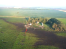
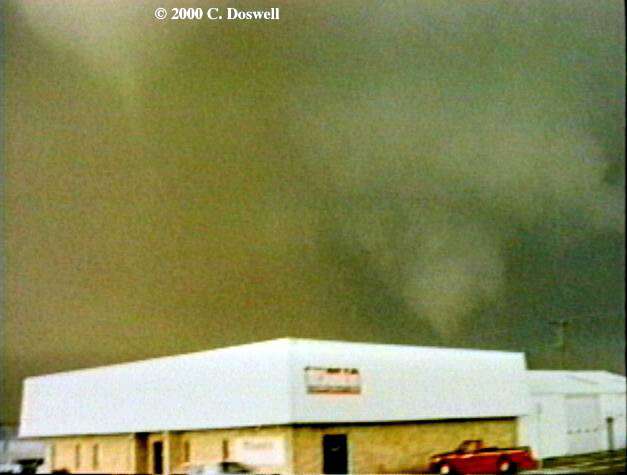
Doswell's chase logs do have a few pictures of Pampa's demise, with the Hoover funnel cloud in the background:

pampa25.JPG

pampa26.JPG

You can also see Pampa begin to lift at the end of Sheriff Stubblefield's video. This is basically what was represented in the 2nd photo from the OKweather blog.

Since at this point Pampa was around ~10 minutes into its 11 minute lifespan, and the mapped path of the tornado shows Pampa didn't get far into the residential area after crossing Price Road as Hoover started to coalesce, I think the 6 minute quote was just an error of memory.

Interesting aftermath photos from Dalton, had not seen those before. I will say that Mulvane's automobile damage was more impressive than I anticipated. While likely underrated I didn't remember Mulvane as being as visually impressive as some of these other tornadoes, but those cars definitely meet the definition of "mangled beyond recognition"...like some of the other drill bits on the list, Mulvane also had a spectacular shrinking/rope stage where it attained its highest wind speeds, although it seems to differ in that it didn't appear to reach violent class intensity before its shrinking stage.

Since Dalton's highest wind speeds seemed to occur closer to the end of its life, a possibility is that its ground scouring appears less prominent than Wilkin's because it was most intense when the tornado was thinner - though I'm not sure the aerial views really bear this out. But yes, undoubtedly still impressive. It would seem to me that the scour patterns from these smaller tornadoes are not necessarily far narrower than those of most violent wedges, for the most part; this seems consistent with the observation that only a small core in most such monsters is doing the worst damage (subvortices notwithstanding) whereas pretty much the entire condensation funnel of a drill bit is core. It also makes Jarrell all that much more of an anomaly.

Someday I think I am going to have to look for pictures of scouring from Pampa. A newspaper clipping mentioned that the tornado drained 10-12 ft of water from a dammed pond, coupled with what are perhaps the highest vertical wind speeds seen in any tornado to date I would think Pampa would have been more than capable. The lack of imagery is indeed quite unfortunate.

Now, as for an event that's less remarkable in terms of strength, here's Dallas/Lancaster from 2012:


Probably most well known by the public for being caught on tape lifting tractor trailors, and most well known by myself for striking pretty close to home. This footage displays an interesting transition where what had previously been a stubby medium sized stovepipe disappears and then reorganizes into an elephant trunk before restrengthening. Perhaps not uncommon, but what I don't know is whether it was entering its shrinking stage, or whether this was a "secondary" mature stage, like a reverse Andover if you will.

That is indeed fascinating, I don't think I'd remembered it myself. Though they probably comprise a relatively small percentage of violent tornadoes (or, at least, violent tornadoes that were actually rated as such), drill bits certainly do seem to be responsible for quite some amount of interesting phenomena.

I knew little about lancaster TX tornado,This video really attracts me as it shows two appearance occurred in a short time,especially a violent rotating tight wedge converted into a cone is something rare, I can hardly find out another events that has the same developing process with this one.However,I did remember some similar events
Like the Last chance,CO tornado on 7/21/1993.The tornado had a great full life span documentation here http://stormbruiser.com/chase/1993/07/21/july-21-1993-last-chance-colorado-tornado/
78b185a4c568860cf21768d203312171.jpg
-2f23d917643ce4a2d07c1c09d9bff9b0.jpg
-213b754abd26951a609582e80884ca48.jpg
Another case was the Quinter KS tornado on 5/23/2008.
This video had some good recording

27d32aea46e0887b9853bc3ce4ccb3e9.jpg
IMG_20200728_025639.jpg
73a24dadc74127a19ad02e2ca5232ff7.jpg
 
Last edited:
Messages
43
Reaction score
97
Location
Raleigh, NC
With the hurricane season's peak ahead of us, I thought it would be interesting to do a little illustrative write-up on the most destructive and perhaps most intense tornado ever spawned by an Atlantic hurricane. The history of violent, hurricane-spawned tornadoes is quite short- one in Galveston during Hurricane Carla(1961) and again three years later in Larose, LA during Hurricane Hilda(1964). I'll be focusing on the latter.

Larose was a small fishing village situated along the Bayou LaFourche about 70 miles to the south of New Orleans. The town's population, 50-100 normally, had risen by several hundred as evacuees moved inland to avoid the wrath of Hilda. Several other tornadoes touched down in the area the morning hours of October 3rd, arriving a full 12 hours or so before Hilda's landfall along the Louisiana coastline. There were two F2's and two F0's. The most noteworthy of these was an F2 that injured five while cutting a path through New Orleans' French Quarter at about 9am. The Larose storm touched down around 6:30 in the morning and most likely stayed on the ground for only a few minutes before lifting. The damage path was described as 50 yards wide and two miles long through Larose with the most intense damage occurring along the Bayou LaFourche. Brick frame homes were leveled(difficult to ascertain degree of anchoring), vehicles were tossed considerable distance, and twenty-two people perished in a two mile stretch.
Aerial Shots
LaroseLAOct63aerialview.jpg
LaroseLAOct63aerial2.jpg
Home damage(construction dubious)
LaroseLAOctober63.jpg
LaroseLAOct63F4(4).jpg
Vehicle damage and general debris field
LaroseLAOct63F4(2).jpg
LaroseLAOct63vehicle.jpg
LaroseLAOct63debris2.jpg

Based on what I've seen, the Larose storm is probably the most violent tropically spawned tornado to be reliably documented. The Galveston F4 seems to be a notch below.
 
Messages
2,157
Reaction score
2,713
Location
Missouri
With the hurricane season's peak ahead of us, I thought it would be interesting to do a little illustrative write-up on the most destructive and perhaps most intense tornado ever spawned by an Atlantic hurricane. The history of violent, hurricane-spawned tornadoes is quite short- one in Galveston during Hurricane Carla(1961) and again three years later in Larose, LA during Hurricane Hilda(1964). I'll be focusing on the latter.

Larose was a small fishing village situated along the Bayou LaFourche about 70 miles to the south of New Orleans. The town's population, 50-100 normally, had risen by several hundred as evacuees moved inland to avoid the wrath of Hilda. Several other tornadoes touched down in the area the morning hours of October 3rd, arriving a full 12 hours or so before Hilda's landfall along the Louisiana coastline. There were two F2's and two F0's. The most noteworthy of these was an F2 that injured five while cutting a path through New Orleans' French Quarter at about 9am. The Larose storm touched down around 6:30 in the morning and most likely stayed on the ground for only a few minutes before lifting. The damage path was described as 50 yards wide and two miles long through Larose with the most intense damage occurring along the Bayou LaFourche. Brick frame homes were leveled(difficult to ascertain degree of anchoring), vehicles were tossed considerable distance, and twenty-two people perished in a two mile stretch.
Aerial Shots
View attachment 4181
View attachment 4182
Home damage(construction dubious)
View attachment 4183
View attachment 4184
Vehicle damage and general debris field
View attachment 4185
View attachment 4186
View attachment 4187

Based on what I've seen, the Larose storm is probably the most violent tropically spawned tornado to be reliably documented. The Galveston F4 seems to be a notch below.
Incredible that 22 people were killed in the space of only 2 miles and likely a few minutes, I've head about this thing before and I do wish there were more high-quality photographs of its damage available; I can't help but wonder if this thing achieved F5 intensity but the construction material of the buildings it struck was likely dubious at best, so they couldn't go any higher than F4 with ranking it.
 

buckeye05

Member
Messages
3,121
Reaction score
4,581
Location
Colorado
With the hurricane season's peak ahead of us, I thought it would be interesting to do a little illustrative write-up on the most destructive and perhaps most intense tornado ever spawned by an Atlantic hurricane. The history of violent, hurricane-spawned tornadoes is quite short- one in Galveston during Hurricane Carla(1961) and again three years later in Larose, LA during Hurricane Hilda(1964). I'll be focusing on the latter.

Larose was a small fishing village situated along the Bayou LaFourche about 70 miles to the south of New Orleans. The town's population, 50-100 normally, had risen by several hundred as evacuees moved inland to avoid the wrath of Hilda. Several other tornadoes touched down in the area the morning hours of October 3rd, arriving a full 12 hours or so before Hilda's landfall along the Louisiana coastline. There were two F2's and two F0's. The most noteworthy of these was an F2 that injured five while cutting a path through New Orleans' French Quarter at about 9am. The Larose storm touched down around 6:30 in the morning and most likely stayed on the ground for only a few minutes before lifting. The damage path was described as 50 yards wide and two miles long through Larose with the most intense damage occurring along the Bayou LaFourche. Brick frame homes were leveled(difficult to ascertain degree of anchoring), vehicles were tossed considerable distance, and twenty-two people perished in a two mile stretch.
Aerial Shots
View attachment 4181
View attachment 4182
Home damage(construction dubious)
View attachment 4183
View attachment 4184
Vehicle damage and general debris field
View attachment 4185
View attachment 4186
View attachment 4187

Based on what I've seen, the Larose storm is probably the most violent tropically spawned tornado to be reliably documented. The Galveston F4 seems to be a notch below.
A death toll that high from such a brief tornado suggests that it was likely genuinely violent. That’s extremely impressive, and not to mention tragic.
 
Messages
43
Reaction score
97
Location
Raleigh, NC
Incredible that 22 people were killed in the space of only 2 miles and likely a few minutes, I've head about this thing before and I do wish there were more high-quality photographs of its damage available; I can't help but wonder if this thing achieved F5 intensity but the construction material of the buildings it struck was likely dubious at best, so they couldn't go any higher than F4 with ranking it.
It may have been capable but I doubt it given that its short track over a fairly populated area. It certainly was violent though. There were frail buildings along its path for sure but reports and aerial photos indicate that the tornado leveled some fairly large and ostensibly well built homes as well.
A death toll that high from such a brief tornado suggests that it was likely genuinely violent. That’s extremely impressive, and not to mention tragic.
Ten members of the same extended family perished in the tornado as well. I think the area basically doubling or tripling in population due to Hilda, the erratic nature of hurricane spinups, and the time of day(630am) all contributed to the high fatality rate as well. Add in no basements and you've got a bad situation. Even today those circumstances and the violent nature of the tornado would make for a terrible end result.
 
Messages
2,157
Reaction score
2,713
Location
Missouri
It may have been capable but I doubt it given that its short track over a fairly populated area. It certainly was violent though. There were frail buildings along its path for sure but reports and aerial photos indicate that the tornado leveled some fairly large and ostensibly well built homes as well.

Ten members of the same extended family perished in the tornado as well. I think the area basically doubling or tripling in population due to Hilda, the erratic nature of hurricane spinups, and the time of day(630am) all contributed to the high fatality rate as well. Add in no basements and you've got a bad situation. Even today those circumstances and the violent nature of the tornado would make for a terrible end result.
Hurricane-spawned tornadoes are usually weak, correct? Are there any ideas on what would allow one to achieve such rapid intensity in extremely short time?
 
Messages
43
Reaction score
97
Location
Raleigh, NC
Hurricane-spawned tornadoes are usually weak, correct? Are there any ideas on what would allow one to achieve such rapid intensity in extremely short time?
Yeah they're mostly of the EF0-EF2 variety. The most prolific tornado producing hurricanes seem to be majors that weaken before striking the Gulf Coast. Ivan, Rita, and Katrina all come to mind in addition to Hilda and Carla. TS Lee as well but that's different. So I'd speculate the drier, colder air that gets entrained into a decaying tropical system acts to enhance instability(lapse rates, surface heating)in the RFQ area where low-level shear is highest. You can also get low-topped mini sups when the RFQ is void of tropical convection. Maybe enhanced mid-level shear impinging on the strong low-level circulation plays a role as well. I'll defer to people that know more than me in making definitive statements but that makes sense to me.
 
  • Like
Reactions: Tre
Messages
2,157
Reaction score
2,713
Location
Missouri
Yeah they're mostly of the EF0-EF2 variety. The most prolific tornado producing hurricanes seem to be majors that weaken before striking the Gulf Coast. Ivan, Rita, and Katrina all come to mind in addition to Hilda and Carla. TS Lee as well but that's different. So I'd speculate the drier, colder air that gets entrained into a decaying tropical system acts to enhance instability(lapse rates, surface heating)in the RFQ area where low-level shear is highest. You can also get low-topped mini sups when the RFQ is void of tropical convection. Maybe enhanced mid-level shear impinging on the strong low-level circulation plays a role as well. I'll defer to people that know more than me in making definitive statements but that makes sense to me.
Are they usually narrow, drillbit type tornadoes? I imagine there isn't a whole lot of (if any) hurricane-spawned wedges.
 
Messages
2,157
Reaction score
2,713
Location
Missouri
Think I may have been that youtube commenter in question! What a coincidence...I saw the video of the Dalton tornado, was reminded of Wilkin County, remarked on the similarities between the 4 of the drill bits mentioned in the last couple of pages, did a quick google search on Pampa 1995 to see if any information had been recovered since I last looked up the subject. One thing lead to another and I found both the tornadotalk article and this thread, with all the information compiled recently!

I believe I got my original information about the data loss from my correspondence in 2013 with Jose Garcia at NWS Amarillo. I am sad to say that in an ironic twist (no pun intended) of fate, I've failed to keep up with the topic in the last several years, and have actually lost that conversation along with a lot of my meteorological knowledge. Any new data about the event is still sure to turn a head, though - and I am sure I am not the only one. Pampa's legendary status combined with the lack of readily available information online lends to a bit of mystique, I think.

A little bit to add on to the various events that have been discussed. Back in the day I talked a bit with Max from extremeplanet.me about the Pampa storm, he mentioned that he had a limited edition addendum at the end of one of his books where Grazulis noted that his personal photogrammetry indicated wind speeds of approximately 300 mph 100 ft AGL. That combined with its spectacular rotation, numerous feats of strength, and extreme vehicle damage leads me to the belief that Pampa was perhaps the strongest of the four drill bits. Grazulis himself did say he thought it had the highest wind speeds of any tornado he'd seen at the time of the writing; Garcia noted that had it occurred in modern times, with the updated EF scale, it would have almost certainly attained an EF5 rating. The main difficulty in actually confirming all that is the lack of photos displaying affected vegetation which, I think, would arguably be more useful than an example of what would have happened if the tornado actually struck a well built residential structure at full strength. Buildings can only take so much before they blow away, after all...tree trunks and ground scouring leave a bit more evidence to be evaluated. We do have this video shot, for what it's worth:


Very low resolution, but many of these trees look to be severely stripped and snapped off low to the ground. A pity we don't have a close up shot with higher color quality, then we'd be able to gauge the level of debarking.

It would not surprise me if Dalton were itself a bit underrated. As I recall, the building that was destroyed was struck while the circulation was still in the process of transitioning from its organizing to its mature stage. (Also of note, that process looked quite similar to Pampa's own.) The most violent rotation, similar to Elie, seems to occur somewhere around the shrinking stage. And to point out a further commonality with its compatriots, the twister lasted for exactly the same number of minutes (31) as Wilkin!

Wilkin used to have a NWS page detailing its damage and the rationale for its rating. Sadly, like much of the information about Pampa, it seems that page is now gone. I recall that it may have said that trees at the surveyed damage sites were stripped but not debarked...memory's a bit fuzzy on that. Given some of the photos of more severe tree damage posted in this thread I wouldn't be surprised if they missed a few areas, I definitely see at least one debarked trunk here. The ground scouring was certainly quite impressive, the NWS page had a ground level shot showing beets torn out of the earth in a concentrated swath and of course we've got that awesome aerial footage to go on.

Agreed with eric that Elie earned its higher rating more due to chance and circumstance than strength. I think though that it actually didn't travel over the same place twice - didn't retrace its footsteps, so to speak. extremeplanet.me had an analysis of the event (also now sadly disappeared, I'm sensing a trend here) and the tornado's path. My thoughts on the matter are that drill bit tornadoes probably do tend to be a bit underrated in general, their extremely narrow width means they need to hit an object pretty much dead on. Couple that with their usually occurring up north over plains and they don't have the opportunity to leave as many indicators of their intensity. Elie however by pure (bad) luck managed to strike pretty much every house in the immediate area, thus leaving no doubt. If it turned out that it was actually the weakest of the 4, frankly I'm not sure I would be surprised.

But it's all academic anyhow, the weather nerd equivalent of arguing over sports teams if you will. Have to say I haven't had an opportunity to do that in a long time though! I do wonder if in the future, as our knowledge of the subject grows, we'll start increasingly parsing out the common characteristics of the different forms of tornadoes. Terminology like drill bit, dust bowl, wedge, etc. could become a bit more formalized, much like the different breeds of supercells are now (HP, classic, LP).

Another thing I've noticed about drillbits is they tend to have much shorter path lengths and as a result, less likely to hit something; not too knowledgeable of long-lived drillbits.
 

warneagle

Member
Messages
3,729
Reaction score
3,208
Location
Arlington, VA
Special Affiliations
  1. SKYWARN® Volunteer
Yeah they're mostly of the EF0-EF2 variety. The most prolific tornado producing hurricanes seem to be majors that weaken before striking the Gulf Coast. Ivan, Rita, and Katrina all come to mind in addition to Hilda and Carla. TS Lee as well but that's different. So I'd speculate the drier, colder air that gets entrained into a decaying tropical system acts to enhance instability(lapse rates, surface heating)in the RFQ area where low-level shear is highest. You can also get low-topped mini sups when the RFQ is void of tropical convection. Maybe enhanced mid-level shear impinging on the strong low-level circulation plays a role as well. I'll defer to people that know more than me in making definitive statements but that makes sense to me.
Katrina dropped an F2 in Peach County, Georgia that wiped out a credit union about a third of a mile from my dad's office, as well as some of the big pecan orchard that runs behind it. Thankfully it was pretty narrow (about 50 yd) and moving in the other direction, and he only lost some shingles. It was after closing time so nobody was in the credit union at the time. I couldn't find any damage photos, but you can see a bit of footage of the damage to the credit union in the second video on this page: https://www.13wmaz.com/article/news...hurricane-katrina-hit-central-ga/93-557331899

The only tornado-related fatality during Katrina was from another F2 Carroll County, Georgia, about 100 miles to the northwest. Katrina produced 6 F2s in total.
 
Last edited:
Messages
2,157
Reaction score
2,713
Location
Missouri
So apparently Charles City had the fastest documented windspeeds of any tornado of all time lol. Amazing what people belie

View attachment 4189
Yeah, I get that reconstructing the pre-1970 ratings with the information that was available at the time was difficult, but the level of inconsistency is still kind of surprising.
Well apparently Charles City had the fastest windspeeds documented in any tornado ever, lol. Amazing that it's still considered F5 after all these years.

528.jpg
 
Last edited:
Messages
2,157
Reaction score
2,713
Location
Missouri
View attachment 3225


View attachment 3226


This picture of the Carney OK 2013 tornado reminds me of the 1999 Moore tornado given the size and radar presentation. This tornado was more underrated than Shawnee and Moore (2013)but, the vortices during its early stages we're almost certainly above 200 MPH. The horizontal vortex look as textbook I will ever see.

It had GTG shear over 200 MPH right when it was about to hit Carney
At 2:37 in this vid you can something a virtually identical horizontal vortex on Red Rock, man that thing was incredible and likely had an insane amount of violent potential.


buckeye05

Member
Messages
3,121
Reaction score
4,581
Location
Colorado
So apparently Charles City had the fastest documented windspeeds of any tornado of all time lol. Amazing what people belie

View attachment 4189

Well apparently Charles City had the fastest windspeeds documented in any tornado ever, lol. Amazing that it's still considered F5 after all these years.

View attachment 4190
I’ve said this before, but estimating wind speed based on spiral markings is complete and utter pseudoscience. Unfortunately, Dr. Fujita used this method for some of his ratings, namely Goessel and Xenia. Both of those have undeserved reputations for being remarkably violent because of this. In reality, there wasn’t much that was really remarkable about them at all. Both would be rated EF4 today.

Oh and I know this is blasphemy, but I take Plainfield’s F5 rating with a healthy dose of skepticism. I mean come on it was based on CORN! Not removal of grass, topsoil, or any typical type of scouring that is known to be associated with violent tornadoes. I do not buy it.Yes, Fujita revolutionized the field, but people need to stop taking his old studies as gospel. Some of his methods and calls do not hold up to modern-day scrutiny.
 
Back
Top