Today I attended a Chinese tornado investigation conference held by professors from Beijing University Atmospheric and Oceanic Science institution.They've mentioned three EF4 occurred on 8/11/2017 in Chifeng city,Inner Mongolia,China.Unfortunately,only one of the three EF4s had great documentation and the other two occurred in rural areas so little information I can get,I talked to one professor who were in the damage survey team at that time and she told me they were still collecting damage photos and trying to write research papers about these three EF4s.So here's what I've got and what I can find from that event.
The first one,which was an at least a mile-wide wedge,touched town in a shallow valley,It only last 10 mintues and covered a damage path only 2 miles,which means this tornado was rather slow moving.The tornado first moved slowly to the north,stayed stagnant for a while,and then recurved to the northeast,disappered on a mountain.A town,abbreviated "QJC",was on the edge of the tornado's path.Two concrete-red brick mixed FR12 was completely demolished,only left a pile of debris on its basement.Bricks and concrete fragments were thrown long distances.
track map.The red line area indicates EF4 damage.
View attachment 4102
house leveled
View attachment 4103View attachment 4104
The second one,which also touched down in a river valley,has the least information.I have no idea when the tornado touched down,how long it lasted,how far it went,but one thing for sure,this one was also at least a mile-wide in his full life span,maybe even bigger than the first one.A town,abbreviated "SLP" was on the left edge of the tornado.I've heard this one also leveled numerous houses but I can't make sure whether some damage photos were belonged to this one so here's only the track map.
View attachment 4105
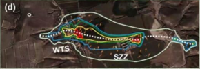
As the second EF4 missing the town.The third EF4 formed to the east of the second one in the same river valley,the two EF4s were on the ground simultaneously for about 3-5 mintues,like the pilger twins event.The second one quickly curved to the north and disspates while the third one heading directy to the east and then climbed a mountain, growing in size and strength,the third one then directly went through the town abbreviated "WTS",here was the most severe damage occurred,entire rows of brick-concrete-mixed one or two story big houses were completeley swept away,some only left clean foundation,debris was scattered downwind for long distances,reinforced concrete poles are broken off at ground level,hardwood trees nearby only left debarked trunks and no leaves or branches remaining,small branches deeply embedded into concrete walls,tractors were mangled and thrown several hundred yards away,a water tank weighing between 3-5 tons were thrown four miles away according to local residents.Ground scouring was obvious as the tornado left the town and went downhill.Again the tornado "dived"into another valley and again climbed another mountain,slightly shrinking in width and strength,tornado encountered another town,abbreviated "SZZ".EF4 damage took place again where numerous well-anchored brick homes were completely swept away left only piles of rubbles,the tornado then climbed to the peak of the mountain and quickly disspated. In all,five people were killed,58 were injured.
track map.
View attachment 4108
damage at WTS town.
View attachment 4109
View attachment 4111
View attachment 4112
damage near SZZ town
View attachment 4113
Forgive for the photo quality,cuz I screenshot from the conference and resolution may lose a bit.If anyone needs more damage photos,I'll add some.


.jpg")