SilentShadow87
Member
Vicksburg is going to be right in the path of this one...
Follow along with the video below to see how to install our site as a web app on your home screen.
Note: This feature may not be available in some browsers.
I think Piotrowski is there if you can tolerate him.Are there any chasers near Vicksburg?

uhhh nevermind...
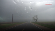
Yeah, it's massive and heavily rain-wrapped. You can sort of see it here on the left side.if it is on the ground, it is huge
Brandon Copic is in Vicksburg waiting on it......Live Storm Chasing https://livestormchasing.com/mapAre there any chasers near Vicksburg?
Am I in trouble??uhhh nevermind...
Brandon Copic is in Vicksburg waiting on it......Live Storm Chasing https://livestormchasing.com/map