
yes, I think this is the area to watch in the next several hours.Big temperature contrast from NW Louisiana to the Central parts and over into southern Mississippi. I guess when the storms start hitting that much warmer air, things may really light up?
View attachment 1392
Navigation
Install the app
How to install the app on iOS
Follow along with the video below to see how to install our site as a web app on your home screen.
Note: This feature may not be available in some browsers.
More options
-
Welcome to TalkWeather! We see you lurking around TalkWeather! Take the extra step and join us today to view attachments, see less ads and maybe even join the discussion. CLICK TO JOIN TALKWEATHER
You are using an out of date browser. It may not display this or other websites correctly.
You should upgrade or use an alternative browser.
You should upgrade or use an alternative browser.
Just based on my social media activity, responses, shares, and comments- I too get the feeling that the threat isn't being taken seriously, hopefully, I am wrong.
Equus
Member
I'm fair positive that some in AL heard it rain overnight and this morning and thought "haha wow they got it way wrong, it's already over and was just rain, time to go back to watchin' golf"
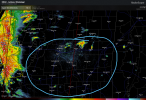
Take a look at the shear and what happens tonight...east of the MIss River, that might answer your questionRadar currently shows what appears to be a fairly solid line of storms about to cross the Mississippi River. Are the parameters on the other side of the river in a favorable position to break the line into discrete cells?
Attachments
Equus
Member
HRRR still likes the idea of relatively discrete cells well into AL, so I'm more concerned about MS and west AL than I am for much of LA at this point
HRRR still likes the idea of relatively discrete cells well into AL, so I'm more concerned about MS and west AL than I am for much of LA at this point
yes, but it could start in west Miss as well....
EDIT
actually after looking at VIS, maybe not. There may be lull between now and when central/east miss begins to fire

Last edited:
Equus
Member
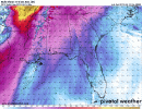
STP values of 6 well into MS now so I get the feeling MS could be the state to watch overall one stuff starts getting going there
- Moderator
- #369
Close lightning strike just now! Should just be a noisy storm.
Equus
Member
Chaser reporting fatality at Alto and home swept away (possible mobile home? Lots of undamaged pine trees)
yes, that is correctRight now I feel as though we're in a "hurry up and wait" position regarding what should be the next part of this event (i.e. the MS part of the event).
Equus
Member
Embedded HP storm headed for Vicksburg is getting 'that' look; if it drops something it's going to be completely rain wrapped
- Staff
- #374

Equus
Member
I fear Vicksburg storm is about to drop something BIG. It's really rapidly wrapping up...
Equus
Member
There's the TOR. Couplet VERY intense

WOW very intense and rain wrapped!
TornadoFan
Member
Holy crap, that wrapped up in a hurry.
warneagle
Member
WOW