
Basically we're gonna have a severe weather threat or at least a risk during the next 2 to 5 weeks.
Navigation
Install the app
How to install the app on iOS
Follow along with the video below to see how to install our site as a web app on your home screen.
Note: This feature may not be available in some browsers.
More options
-
Welcome to TalkWeather! We see you lurking around TalkWeather! Take the extra step and join us today to view attachments, see less ads and maybe even join the discussion. CLICK TO JOIN TALKWEATHER
You are using an out of date browser. It may not display this or other websites correctly.
You should upgrade or use an alternative browser.
You should upgrade or use an alternative browser.
Severe Weather 2022
- Thread starter Taylor Campbell
- Start date
- Status
- Not open for further replies.
KevinH
Member
ShockerBasically we're gonna have a severe weather threat or at least a risk during the next 2 to 5 weeks.
Yeah exactly! LOL!Shocker
CheeselandSkies
Member
Out of 46 confirmed U.S. tornadoes in 2022 to date, 16 have been in Alabama including all 9 in February. Next are Kentucky with 10, and Florida with 8.
KevinH
Member
Not surprised… I always say “Alabama is the Oklahoma of the south” Out of 46 confirmed U.S. tornadoes in 2022 to date, 16 have been in Alabama including all 9 in February. Next are Kentucky with 10, and Florida with 8.

Weatherphreak
Member
I feel like that’s pretty normal. January-March mainly Dixie alley/Gulf Coast events shifting west and north April-June. Obviously south is still in play through May.Out of 46 confirmed U.S. tornadoes in 2022 to date, 16 have been in Alabama including all 9 in February. Next are Kentucky with 10, and Florida with 8.
It's very interesting how quiet it is on here especially given a heavy rain and severe weather threat this week.
tennessee storm chaser
Member
- Messages
- 1,877
- Reaction score
- 4,288
- Location
- jackson tennessee
- Special Affiliations
- SKYWARN® Volunteer
100 percent agree with u .. always come here to get some good severe talk before spring season . We are getting some threats , but been so quiet . Maybe as the events get little worse things pick up.It's very interesting how quiet it is on here especially given a heavy rain and severe weather threat this week.
- Admin
- #109
- Messages
- 3,619
- Reaction score
- 3,434
- Location
- Fayetteville, AR
- Special Affiliations
- SKYWARN® Volunteer
Moved a few of the relevant posts to a dedicated thread

 talkweather.com
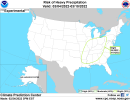
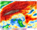
Severe WX - Severe Weather Threat 2/21-2/22, 2022
Yes, there are severe weather threats on the map in the Southeast US for next Tuesday and Thursday. The week after also has severe potential. I think I am seeing what you're talking about on the Euro, GFS, and somewhat the NAM but I want to know if you too are seeing a two day event on the 22nd...
CheeselandSkies
Member
It's fantasyland of course, but the last few runs of the GFS have had a big trough in the west late in the run with some instability (greater values than the model portrayed at medium-long range with the last few events, including today's) developing inland over the southeastern states.
- Thread starter
- Moderator
- #111
It's fantasyland of course, but the last few runs of the GFS have had a big trough in the west late in the run with some instability (greater values than the model portrayed at medium-long range with the last few events, including today's) developing inland over the southeastern states.
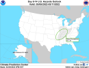
The 10-14 day forecast looks threatening for severe weather. Watch the week of March 6th-12th.
There you go @Taylor Campbell
Attachments
gregassagraf
Member
Captured this gorgeous supercell yesterday here in Pouso Alegre, Brazil.

this thing was very menacing at one point!
this thing was very menacing at one point!
Looks like a wet and stormy period is coming up the first 2 weeks of March.
Attachments
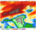
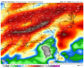
The 12z GFS Extended Ensemble Control and 12z GFS Operational total rainfall through March 12th and 13th. The main takeaway is not the total rainfall amounts but the idea of a wet/stormy pattern coming up.
Attachments
- Thread starter
- Moderator
- #117
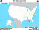
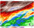
CIPS extended

gregassagraf
Member
I’m a little bit worried for Argentina this afternoon. Region around Rio Cuarto with CAPE at nearly 3000K with wind shear at 30 m/s. That region has had some rough weather for the last few days, but today things are kind of maxed out! The CAPE*Shear factor is surpassing 1500 at some locations.
CheeselandSkies
Member
By Sat/D7, models indicate increased low-level moisture return over
the southern Plains as a large upper trough develops over the
western CONUS. The ECMWF members show a strong midlevel jet emerging
into the central/southern Plains at this time, and indications are
that this wave may eject rather quickly northeast. Dewpoints up to
60 F may spread as far north as eastern OK as a low deepens over the
upper MS Valley. While some degree of severe threat may develop
along the trailing dryline or cold front, instability is forecast to
be relatively weak and will also depend on heating.
For Sun/D8, shortwave ridging is forecast over the Plains as a
secondary wave (still within the large-scale mean trough) moves
across the Four Corners states. A boundary would likely be in place
across parts of the southern Plains in the wake of the Sat/D7
system, and increasing southerly flow late Sun/D8 into Mon/D9 could
potentially result in severe potential as moisture returns north.
The second wave, if the ECMWF ensemble verifies may yield greater
severe potential as boundary layer moisture will have had a longer
time to increase across TX and toward the lower MS Valley (mid to
upper 60s F). If models remain consistent, one or more severe areas
may eventually be added in later outlooks as predictability
warrants.
..Jewell.. 02/27/2022
gregassagraf
Member
It has started!
- Status
- Not open for further replies.