
Sorry, didn't know it was up yet. Thanks for letting me know!Clancy, there is a dedicated thread for Friday/Saturday’s threat at https://talkweather.com/threads/severe-weather-threat-3-10-3-12-2022.1938/.
Navigation
Install the app
How to install the app on iOS
Follow along with the video below to see how to install our site as a web app on your home screen.
Note: This feature may not be available in some browsers.
More options
-
Welcome to TalkWeather! We see you lurking around TalkWeather! Take the extra step and join us today to view attachments, see less ads and maybe even join the discussion. CLICK TO JOIN TALKWEATHER
You are using an out of date browser. It may not display this or other websites correctly.
You should upgrade or use an alternative browser.
You should upgrade or use an alternative browser.
Severe Weather 2022
- Thread starter Taylor Campbell
- Start date
- Status
- Not open for further replies.
- Thread starter
- Moderator
- #142
You are welcome @Clancy. Thank you for adding the outlook graphic to the thread.
Let’s keep an eye out for early next week for a severe threat with a closed low. Super cold air aloft will make up for the minimal dew point recovery after this weekend’s powerful system. Models also show another system at the end of the week and have a look for more threats down the pipe the week of the 20th. Stay alert!
Let’s keep an eye out for early next week for a severe threat with a closed low. Super cold air aloft will make up for the minimal dew point recovery after this weekend’s powerful system. Models also show another system at the end of the week and have a look for more threats down the pipe the week of the 20th. Stay alert!
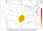
D4 and D5 have 15% outlines. Discussion also mentions possibility for more threats later in the 4-8 period.

...Monday/Day 4 to Tuesday/Day 5...
On Monday, the medium-range models move an upper-level trough across
the southern Plains. An associated cold front is forecast to move
eastward as low-level moisture advection takes place ahead of the
front from eastern parts of the southern Plains into the Arklatex.
Strong to severe thunderstorm development will be possible ahead of
the trough across the Arklatex from late Monday afternoon into the
evening, and possibly further to the east during the overnight
period. This system is forecast to track eastward into the lower
Mississippi Valley on Tuesday as low-level moisture advection
continues in the central and eastern Gulf Coast states. Severe
storms will be possible on Friday ahead of the system from eastern
Mississippi eastward to southern Georgia and northern Florida, where
instability, deep-layer shear and large-scale ascent should be
maximized.
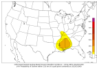
...Wednesday/Day 6 to Friday/Day 8...
From Wednesday to Friday, an upper-level trough is forecast to move
east-northeastward across the Eastern Seaboard, as another
upper-level trough moves eastward across the central U.S. Moisture
return is forecast to increase across the southern Plains and lower
Mississippi Valley Thursday night as a low-level jet strengthens
ahead of the system. As a result, moderate instability may develop
across parts of the Lower Mississippi Valley from Thursday evening
into Thursday night. This combined with strong large-scale ascent
and enhanced deep-layer shear would be favorable for severe storm
development. At this time, uncertainty concerning the timing of the
eastward progression of the upper-level trough is substantial. The
potential for severe storms could continue into Friday as the trough
moves eastward, but predictability appears low toward the end of the
Day 4 to 8 period.
CheeselandSkies
Member
Pattern coming up on the GFS is maybe too active for its own good, with lots of troughs but limited time for moisture recovery between them.
- Thread starter
- Moderator
- #145
The global forecast models show a big weather maker next week. System looks to come onshore the west coast as soon as Sat/Sun.
- Moderator
- #147
It figures. My son is going to Memphis next weekend to see his best friend.
CheeselandSkies
Member
Near/just south and east of the DFW area might have to watch out later this afternoon/evening.
Last edited:
CheeselandSkies
Member
GFS is pretty consistent with one trough pushing through the south-central and southeastern US late this week that may have moisture issues, another around next week Monday/Tuesday that may be a bit too amped/meridional for its own good (but still certainly may result in some severe weather) and then possibly the mother lode late in the run - broader-based, slight negative tilt and with unfettered moisture return. However it keeps waffling between that and turning the middle trough into a cut-off low which stunts the moisture return ahead of the third one. In any case, the overall look is certainly active.
*As I post, SPC in with Day 7/8 areal highlights.
*As I post, SPC in with Day 7/8 areal highlights.
Last edited:
MattW
Member
- Messages
- 388
- Reaction score
- 382
- Location
- Decatur, GA
- HAM Callsign
- KG4GUF
- Special Affiliations
- SKYWARN® Volunteer
Have we seen a D7 and D8 on SPC before?
CheeselandSkies
Member
Have we seen a D7 and D8 on SPC before?
Not super common but it's happened before, on more than one occasion.
- Thread starter
- Moderator
- #152
Equus
Member
If I recall, one point in May 2019 had a severe threat on every day of the outlook from D1 to D8, seeing even half the days highlighted is certainly not common
Just the 6th time SPC issued a day 8 risk area. 
atrainguy
Member
Was just looking at the severe map on wunderground and I see there's a tornado warning currently in Lake County, Florida until 8pm. It says only radar indicated rotation for now.
- Moderator
- #156
Orange County, FL had a tornado warning that just expired, but I'm concerned about that mean looking cell headed for the Disney World area.
- Moderator
- #157
Now there's a tornado warning just east of WDW. The warning was about to expire and NWS issued another one, so hope it doesn't touch down. Very populated area.
MattW
Member
- Messages
- 388
- Reaction score
- 382
- Location
- Decatur, GA
- HAM Callsign
- KG4GUF
- Special Affiliations
- SKYWARN® Volunteer

- Thread starter
- Moderator
- #159
East Georgia into South Carolina and central Florida look hot for severe weather tomorrow. I anticipate the SPC upgrades the marginal in the new Day 1. I’m curious what comes of the severe across the Orlando area tomorrow.
CheeselandSkies
Member
General observation: It's always interesting to me when a forecast sounding with a TOR in the "possible hazard type" box has a more classic-looking vertical wind profile, hodograph, and critical angle than a nearby one which has a "PDS TOR" but might have some visually apparent kinks/veer-backing while the other is "perfect" (winds at each pressure level turn clockwise relative to the one below it). For those more familiar with the model soundings and what all goes into calculating this, what are some possible reasons for this?
*This assumes the thermodynamic environment is generally similar between the two.
*This assumes the thermodynamic environment is generally similar between the two.
- Status
- Not open for further replies.