MattW
Member
- Messages
- 388
- Reaction score
- 382
- Location
- Decatur, GA
- HAM Callsign
- KG4GUF
- Special Affiliations
- SKYWARN® Volunteer
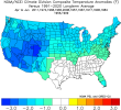
New mesoscale discussion up for East Alabama and West Georgia:
It doesn't seem like they want to go with a watch just yet, but those storms popping up around Troy, AL look interesting.658
ACUS11 KWNS 161620
SWOMCD
SPC MCD 161620
GAZ000-ALZ000-161815-
Mesoscale Discussion 0262
NWS Storm Prediction Center Norman OK
1120 AM CDT Wed Mar 16 2022
Areas affected...parts of south-central Alabama and western Georgia
Concerning...Severe potential...Watch unlikely
Valid 161620Z - 161815Z
Probability of Watch Issuance...20 percent
SUMMARY...Beneath a cold core upper low over the Southeast, isolated
strong/severe storms may develop through the afternoon with a
primary risk of marginally severe hail.
DISCUSSION...As of 1615z, regional visible and water vapor imagery
showed a compact upper low across western AL and eastern MS. SPC
mesoanalysis and morning RAOBS showed a broad cold pocket aloft (H5
Temps near -20C) associated with the upper low. The cold
temperatures aloft and daytime heating are supporting moderately
steep/steepening lapse rates of 7 to 8 C/Km across much of eastern
AL and western GA. The favorable lapse rates and surface dewpoints
in the upper 50s to low 60s F will continue to support weak
destabilization of the warming airmass through the afternoon.
Ongoing showers and storms in the vicinity of Birmingham, AL are
expected to expand in coverage to the north and east with the
movement of the upper low. Additional storms may also develop within
an evolving cumulus field across west-central GA and southeast AL
later this afternoon. The favorable buoyancy/lapse rates may support
a few stronger thunderstorms capable of marginally severe hail or
damaging wind gusts. However, deep-layer shear is less favorable (<
30 kts) beneath the upper low, suggesting limited potential for
broader storm organization. While an isolated strong/severe storm is
possible this afternoon, a weather watch is currently unlikely.
..Lyons/Bunting.. 03/16/2022