MattPetrulli
Member
Would obviously like to see more moisture return but hello


Follow along with the video below to see how to install our site as a web app on your home screen.
Note: This feature may not be available in some browsers.
I was hoping it was a passing wiggle in the GFS when I saw it earlier. I hope this is not a harbinger of the rest of the spring.There's been a strong signal in the Euro weeklies, Euro ensembles, GFS ensembles, and Canadian ensembles for the first few days of April since early last week. The TNI is spiking high-end positive right now, and this coming period is right after a smaller MJO wave (aside from the big standing wave in the IO) crosses past North America at the end of the month. Y'all strap in...
Just insane … wowWould obviously like to see more moisture return but hello
View attachment 12839
View attachment 12840
Most of the events over the past year have failed to meet expectations, so this one may not be very different from the rest, -ENSO/-PDO notwithstanding.I was hoping it was a passing wiggle in the GFS when I saw it earlier. I hope this is not a harbinger of the rest of the spring.
Random question...at what minimum radar beam height do you consider an area to be in a "radar hole"?


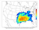
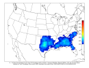
And then MS/TN/AL/maybe GA Wednesday sunset into Thursday morning.12z GFS and Euro kinda starting to converge on something in Arkansas/MS/LA for Wednesday
View attachment 12841
View attachment 12842
Including the last severe weather event and what you've been looking at and future models do you think we're starting to see a possible pattern this season of multiple days connected in the upcoming severe weather events?And then MS/TN/AL/maybe GA Wednesday sunset into Thursday morning.
Guidance currently suggests the low- and mid-level winds will
strengthen on D6/Wednesday, resulting in very impressive wind
profiles. This strengthening of the flow, coupled with the
negatively tilted character to the shortwave and ample low-level
moisture, suggests the potential for numerous severe storms exists.
As a result, higher severe probabilities may be needed in later
outlooks if the current trends within the guidance persist.
Sounds like higher probs maybe needed later outlooks … 0z euro is nasty for ark. West Tn most ms. And western Alabama .Areas in for Days 5/6. Day 5 could be the first substantial Plains chase day of the year, followed by this rather ominous tidbit for Day 6 (the infamous Wednesday):
Please don’t Michelle lol…Someone needs to make a thread for Tuesday/Wednesday. You know it will not be me.
The high-amplitude, linear forcing will likely cut down on higher-end tornado (discrete) probabilities. Despite a near-record-breaking -PDO combined with a moderate or stronger -ENSO, most of the systems this winter have not been the kind of broad, low-amplitude troughs that one would normally expect during such a favourable large-scale background (climatic) state. I have alluded to this elsewhere on this forum. One would expect more widespread, frequent, bigger late-winter/early-spring events during a robust -PDO/Niña, at least to date. However, all this could change as we enter springtime.There is an apparent threat for next Tuesday-Thursday with a fair amount of similarities to the upper and low level wind fields and vorticity like the system we just had Monday-Wednesday; however this threat is still without the severity and consistency of the parameter set that was modeled for the recent event. Let's see if we can trend stronger with the shear and moisture return.
The high-amplitude, linear forcing will likely cut down on higher-end tornado (discrete) probabilities. Despite a near-record-breaking -PDO combined with a moderate or stronger -ENSO, most of the systems this winter have not been the kind of broad, low-amplitude troughs that one would normally expect during such a favourable large-scale background (climatic) state. I have alluded to this elsewhere on this forum. One would expect more widespread, frequent, bigger late-winter/early-spring events during a robust -PDO/Niña, at least to date. However, all this could change as we enter springtime.
The high-amplitude, linear forcing will likely cut down on higher-end tornado (discrete) probabilities. Despite a near-record-breaking -PDO combined with a moderate or stronger -ENSO, most of the systems this winter have not been the kind of broad, low-amplitude troughs that one would normally expect during such a favourable large-scale background (climatic) state. I have alluded to this elsewhere on this forum. One would expect more widespread, frequent, bigger late-winter/early-spring events during a robust -PDO/Niña, at least to date. However, all this could change as we enter springtime.