A pattern flip occurs next week as the West Coast
ridge is
replaced by a
trough, and a
ridge strengthens over the western
Caribbean up into the Bahamas. Have continued to incorporate the
warmer NBM percentiles for highs beginning on Tuesday. The
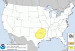
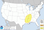
synoptic pattern for Thursday checks a lot of boxes for severe
weather across the Deep South and Mid-South with a low
amplitude
southern stream
trough and
deepening surface low lifting
northeastward across the Ozarks, with an associated mid-level
speed max on the
shortwave`s southeast flank. A strong 60 to 70
kt
LLJ will also bring 65F
dew points northward. I suspect models
are underdoing the forecast
CAPE values in this setup. This system
is several days out and there is some uncertainty regarding how
the southern stream
trough interacts with the northern stream
along with an
upstream wave, but will introduce a low confidence
tornado mention into the HWO.


")