For 2/3/22

Follow along with the video below to see how to install our site as a web app on your home screen.
Note: This feature may not be available in some browsers.
Here's one seasonal tornado forecast for this year that I found recently:
Essentially, based on current conditions and analogs, there's a possibility that this could be an overall slow year for tornadoes (particularly on the Great Plains), though there's always the possibility that things could change later on (so I would personally still recommend always keeping an eye on the weather regardless).
Given the increasing likelihood that the MJO constructively interferes with La Niña, an atmospheric response typical of La Niña is expected across the mid-latitudes of the North Pacific and North America during the latter half of February.
Suprise in the lack of talk and discussion about System late next week .
Agree but coming out a boring pattern we been in catches your eyes stillNeed to see a few more days of run-to-run/model-to-model consistency to see if the look sticks. Not much to say at this point other than there is potential for something there...too far out for details on timing/location/mode.

Woah


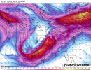
Gfs is basically worthless this far with instability parameters … main thing here getting good agreement with the big picture showing potent short wave amped trough … the euro has cape vals pushing 1000 close lower Ohio valleyThat does look like one potent shortwave forecast to move through the base of that broad longwave trough around a week from now. Saving grace on the GFS (for now) might be marginal instability, but there were questions about that at this range with the 12/10 setup, too.
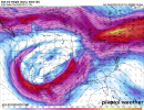
Super Tuesday 2 05 08 is a analog being used ….SPC already introduced areas for Days 6 and 7...gutsy call, but it speaks to the model agreement and consistency observed thus far.