
- Moderator
- #221
Navigation
Install the app
How to install the app on iOS
Follow along with the video below to see how to install our site as a web app on your home screen.
Note: This feature may not be available in some browsers.
More options
-
Welcome to TalkWeather! We see you lurking around TalkWeather! Take the extra step and join us today to view attachments, see less ads and maybe even join the discussion. CLICK TO JOIN TALKWEATHER
You are using an out of date browser. It may not display this or other websites correctly.
You should upgrade or use an alternative browser.
You should upgrade or use an alternative browser.
Severe Weather 2021
- Thread starter Fred Gossage
- Start date
-
- Tags
- severe weather
MattW
Member
- Messages
- 388
- Reaction score
- 382
- Location
- Decatur, GA
- HAM Callsign
- KG4GUF
- Special Affiliations
- SKYWARN® Volunteer
- Thread starter
- #223
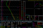
GFS is trending cleaner with the warm sector pre-event on Wednesday, and this allows for a LARGE significantly unstable warm sector (south-central IL and southwest IN, southward to the Gulf Coast). The low-level flow is starting to trend more backed and the low-level jet starts ramping up earlier in the afternoon and over a larger area (GFS and NAM both have a long-standing bias of not correctly handling isallobaric responses in relation to the low-level flow, often over-veering the low-level winds and not being strong enough with the sfc-850mb wind fields). This is trending in a very ugly direction...
CheeselandSkies
Member
Obviously pointing out similarities to historic events is not calling for a verbatim repeat of said historic event (@Fred Gossage )...but that surface pattern, particularly the location of the triple point and warm front as well as the time of year is giving me Tri-State vibes.
- Thread starter
- #225
I could easily see a situation where the setup supports significant tornadoes from directly at the warm front like that, all the way down to south MS/AL.Obviously pointing out similarities to historic events is not calling for a verbatim repeat of said historic event (@Fred Gossage )...but that surface pattern, particularly the location of the triple point and warm front as well as the time of year is giving me Tri-State vibes.
Timhsv
Member
Just looking at the 00Z GFS, the jet structure look's to be a split-jet configuration towards the Mississippi River, with a 500mb jet near 90knts. With the surface low position the winds shouldn't be that veered.I could easily see a situation where the setup supports significant tornadoes from directly at the warm front like that, all the way down to south MS/AL.
Timhsv
Member
Yes sir, indeed.GFS is trending cleaner with the warm sector pre-event on Wednesday, and this allows for a LARGE significantly unstable warm sector (south-central IL and southwest IN, southward to the Gulf Coast). The low-level flow is starting to trend more backed and the low-level jet starts ramping up earlier in the afternoon and over a larger area (GFS and NAM both have a long-standing bias of not correctly handling isallobaric responses in relation to the low-level flow, often over-veering the low-level winds and not being strong enough with the sfc-850mb wind fields). This is trending in a very ugly direction...
Casuarina Head
Member
16 March 1942 featured violent tornadoes from Central IL (Lacon F5) southward to north-central MS (O'Tuckalofa F4).I could easily see a situation where the setup supports significant tornadoes from directly at the warm front like that, all the way down to south MS/AL.
Casuarina Head
Member
I think yesterday’s 12Z GFS featured a more prominent “double-barrelled” signature due to lower amplitude, hence greater mid/upper divergence with height relative to the surface boundary. Today’s 00Z hints at a more amplified synoptic pattern and suggests that there may be greater displacement of the enlarged warm sector from the best supercell/discrete composite(s). This means that localised boundaries may play a bigger role and that the high-end tornado threat may be more restricted than the outward appearance might suggest. In all, I think yesterday’s 12Z run showed a more conducive look for widespread significant tornadoes than today’s 00Z does.
Edit: I take this back; the 850-mb profile is quite similar to that of high-end, widespread outbreaks in terms of SIGTOR.
Edit: I take this back; the 850-mb profile is quite similar to that of high-end, widespread outbreaks in terms of SIGTOR.
Last edited:
Austin Dawg
Member
I could easily see a situation where the setup supports significant tornadoes from directly at the warm front like that, all the way down to south MS/AL.
Does it look like a day or night event for Mississippi and Alabama. I cannot even imagine an bad outbreak at night and don't want to.
- Thread starter
- #231
Things could change, but I think we're locking in on a general midday to midnight timeframe for Wednesday.Does it look like a day or night event for Mississippi and Alabama. I cannot even imagine an bad outbreak at night and don't want to.
Timhsv
Member
As Fred has mentioned above....trending ugly. Welcome to Spring 2021.

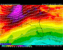
By Day 5/Wednesday, a more substantially unstable environment,
encompassing a large area, is likely, as a moist Gulf airmass
streams northward, beneath rather steep lapse rates advecting
eastward. With an eastward moving surface cyclone and attendant
warm and cold fronts focusing ascent, and the likelihood for broad
warm advection/QG ascent within the expanding warm sector, scattered
severe storms appear likely even given timing/location differences
of surface features amongst the models. While a more concentrated
area or areas of severe weather may evolve Wednesday, those details
-- and any associated outlook highlights -- will require discernment
in subsequent outlooks nearer the event. For now, a large/broad 15%
risk area will be introduced, representing a large envelope of
all-hazards severe potential.
Day 6, model differences become substantial enough that -- while
severe weather risk may continue, no areas will be highlighted due
to the predictability concerns.
..Goss.. 03/13/2021
Attachments
Last edited:


- Thread starter
- #234

I think, already, we really have to entertain the idea that this is one of those type of threats...
I am not liking the looks of next Wednesday. There are some very concerning
Fred, I think you are right. Very concerning.View attachment 6816
I think, already, we really have to entertain the idea that this is one of those type of threats...
warneagle
Member
Should we go ahead and get a thread going for this one? I was going to make one yesterday but decided to wait until the SPC had outlined a risk area.
YesShould we go ahead and get a thread going for this one? I was going to make one yesterday but decided to wait until the SPC had outlined a risk area.
warneagle
Member
Alright, I've got a thread set up. Not sure if the mods will want to migrate the above discussion to that thread.
Brice Wood
Member
Is next Wednesday looking worse than what today could bring?
tennessee storm chaser
Member
- Messages
- 1,876
- Reaction score
- 4,283
- Location
- jackson tennessee
- Special Affiliations
- SKYWARN® Volunteer
Simple yes for nowIs next Wednesday looking worse than what today could bring?