• Welcome to TalkWeather!
    We see you lurking around TalkWeather! Take the extra step and join us today to view attachments, see less ads and maybe even join the discussion.
    CLICK TO JOIN TALKWEATHER

Severe Weather 2021

warneagle

Member
Messages
3,790
Reaction score
3,384
Location
Arlington, VA
Special Affiliations
  1. SKYWARN® Volunteer
Yeah the GFS is picking up on next Tuesday and Wednesday. Still a long way out and a lot of uncertainty (enough that the aforementioned forecaster didn't deem it worthy of a 15% yet).
 

warneagle

Member
Messages
3,790
Reaction score
3,384
Location
Arlington, VA
Special Affiliations
  1. SKYWARN® Volunteer
A tornado watch is up in Minnesota, Iowa, and Wisconsin. Not sure if it really merits a thread.


Equus

Member
Messages
3,295
Reaction score
3,380
Location
Jasper, AL
Special Affiliations
  1. SKYWARN® Volunteer
Some pretty decent rotating storms and impressive low wall clouds thus far but seems to be a fairly localized event
 

warneagle

Member
Messages
3,790
Reaction score
3,384
Location
Arlington, VA
Special Affiliations
  1. SKYWARN® Volunteer
The GFS is looking more active toward the end of the month, with a relatively strong low pressure system in the 23-25 March time frame. Still way off in 300+ hour fantasy land, but something to maybe keep an eye on.
 

KevinH

Member
Messages
1,816
Reaction score
2,888
Location
West Central GA
Sooooo.... I just saw this online from Darin (@darin_deveauWX on Twitter) who made an interesting point. He said that so far, this year is one of the lowest tornado counts in recent history (2005-2020).

That being said, I had a thought (and a response to him): If this spring is *expected* to produce an ABOVE normal tornado count, *AND* we are currently at the LOWEST count through yesterday (for years 2005-2020), how concerned should we about if/when Mother Nature decides to play "catch up" over the next couple of months?:oops::oops::oops:

Annual counts.jpg

I do remember seeing several people say that March will be quiet (for March), and then things will......... change come April and May. So far that is VERIFYING lol
 

Malcolm M

Member
Messages
1
Reaction score
2
Location
Bethesda, MD
Special Affiliations
  1. SKYWARN® Volunteer
I don't think the notion that nature plays "catch up" has much merit... but I certainly agree that the accuracy of the March outlook gives credence to forecasts for the following months
 

Timhsv

Member
Messages
426
Reaction score
758
Location
Meridianville, AL.
Special Affiliations
  1. SKYWARN® Volunteer
CIP's analogs are beginning to become a little more interesting. At DAY 7, it progs a 60% percentile over Central/Southern Mississippi, along with a even 15% tornado probability over Southern Mississippi at DAY 5. Things look to slowly heat up in Dixie Alley. We'll just see how and if it pans out.


7 Day CIPS Analog Severe.PNGCIPS 7 Day Analog TORNADO RSK.PNG
 
Last edited:

Fred Gossage

Member
Meteorologist
PerryW Project Supporter
Messages
596
Reaction score
2,096
Location
Florence, AL
I take that back lol. Things are starting to heat up, more in line with my original thoughts about the 2nd and 3rd week of March.
Hoping that's not an understatement. It looks like we're finally getting the models to see beyond the split flow and upper-level lows, and it looks nasty... starting with this thing in the middle of next week. :oops:
 

Austin Dawg

Member
Sustaining Member
Messages
866
Reaction score
1,335
Location
Leander, Texas
Wow the 12z gfs is loaded with severe weather potential ... couple of them even significant ones
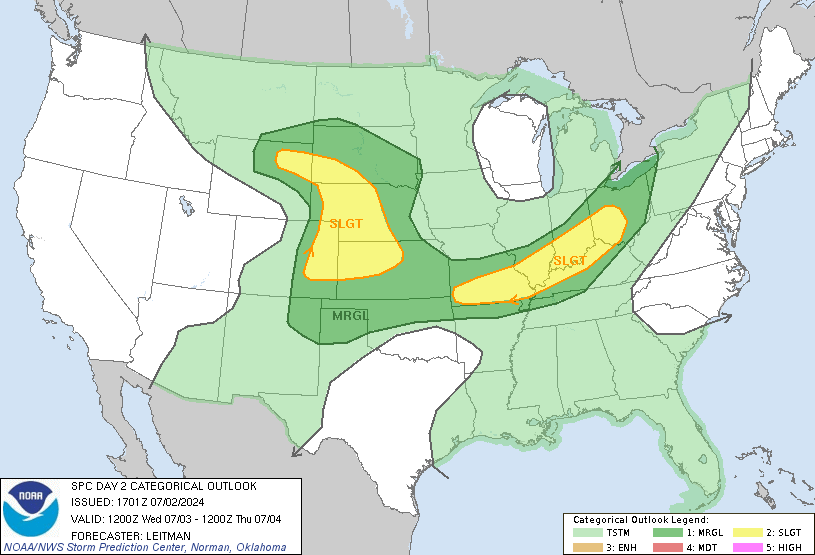
Looks like a busy day tomorrow in the Texas Panhandle region.

day2otlk_1730.gif
 
Logo 468x120
Back
Top