NWMSGuy
Member
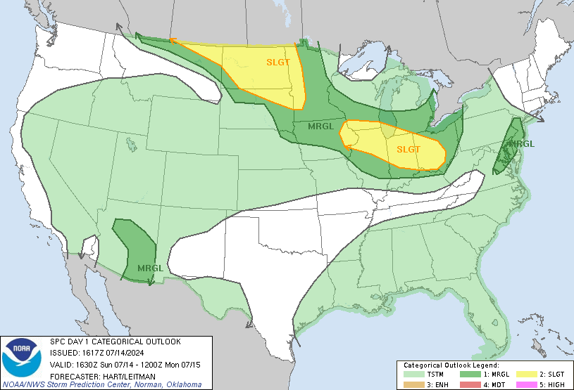
Enhanced Risk has been expanded southward to include parts of Northwest MS
Follow along with the video below to see how to install our site as a web app on your home screen.
Note: This feature may not be available in some browsers.
Tornadoes and pollen,fun times!Gotta love living in the south (especially Bama) in April!! Ugh!

NWS Memphis update:
Looks like primary threat in the MidSouth is high winds/hail. Still nasty, but I'll take it over tornados for sure...

NWS Memphis update:
Looks like primary threat in the MidSouth is high winds/hail. Still nasty, but I'll take it over tornados for sure...
Even if this falls flat in the discrete cell department, a strong QLCS can definitely still produce intense tornadoes. The April 26-27 squall lines during the '11 Super Outbreak spit out five EF3 tornadoes, with one being almost an EF4.
True, and I did say if. This is a tricky system, that's for sure and I wouldn't be too surprised to see some discrete cells out of this.Potentially discrete is actually a little last second surprise the models are throwing in here, so even if it's linear I wouldn't call it "falling flat".
This may surprise some people tomorrow.. this is being a little sneaky.
The addition of enhanced-level tornado probabilities is the main
update to the outlook for now. A few significant tornadoes may
occur as well, especially near the warm-frontal zone and western
part of the enhanced-risk area where relatively discrete convection
is more probable. Should potential for longer-lived supercells and/
or more-sustained bowing structures become apparent, categorical
upgrade to moderate-level wind or tornado probabilities may be
needed in a future update. For now, a little too much mode/
longevity uncertainty still exists to support such a jump.
Looks like we'll get an initial band from some outflow ahead of the main QLCS which will be discrete/semi-discrete in nature across KY/TN/IN. Then, the main QLCS evolves into a LEWP, which will enhance the damaging wind threat.10% hatched TOR on the new Day 1. Definitely wouldn't sleep on some potential warm front riders, these Ohio Valley/Midwest events always seem good for a couple of those.

Operational HRRR seems to like the idea of some beefy supercells over western Tennessee and eastern Arkansas late in the day, through early evening, before it tries to evolve into a linear system.
Sometimes these things will take longer than forecast to turn linear which may bear a watch as well.