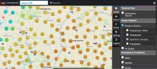
• Welcome to TalkWeather!
    We see you lurking around TalkWeather! Take the extra step and join us today to view attachments, see less ads and maybe even join the discussion.
    CLICK TO JOIN TALKWEATHER

Severe WX February 16-17th, 2022 Severe Threat

Tennie

Member
Messages
935
Reaction score
761
Location
Tennessee
I wonder if people are still getting things prepped for the storms later today. I myself went and got the porch covers on my house lowered down to protect the porch and everything on it.
 

weir003

Member
Messages
8
Reaction score
5
Location
Clements, Alabama
I thought we were supposed to get storms early in north alabama and then possibly a lull around noon before the main event. We haven't had anything to note so far with the main event still sometime away.
 

KevinH

Member
Messages
1,708
Reaction score
2,679
Location
West Central GA
I thought we were supposed to get storms early in north alabama and then possibly a lull around noon before the main event. We haven't had anything to note so far with the main event still sometime away.
Nope.

From NWSBirmingham:
 
Messages
2,753
Reaction score
4,291
Location
Madison, WI
I think the general quietude in here is due to the fact that this is such a conditional threat. SPC put up an enhanced risk because there *could* be a storm or two like the caliber of 2/3 today; or there could be not much of significance at all. Nothing to do really but wait and see what happens.
 

Taylor Campbell

Moderator
Moderator
PerryW Project Supporter
Messages
2,102
Reaction score
2,189
Location
Wedowee, AL
Special Affiliations
  1. SKYWARN® Volunteer
The table is set. We are about to get a significant severe weather event. MD is out and strong tornado potential is real.
 
Last edited:

MichelleH

Moderator
Moderator
Messages
861
Reaction score
1,179
Location
Cullman, AL
I see on the Day 1 update, they shrank the 10% farther west. My county was in the 10% and now we're in the 5%. Of course, that means nothing, because tornadoes can't read.
 
Messages
139
Reaction score
182
Location
Trussville
To me, Jackson misssissippi to Columbus Mississippi to Jasper alabama has the best threat. Models show a lot of rain for north miss and Tennessee so I see that being a huge limiting factor in that area
 

warneagle

Member
Messages
3,729
Reaction score
3,208
Location
Arlington, VA
Special Affiliations
  1. SKYWARN® Volunteer
Yeah I think this is another case where the global models undercooked the thermos on a cool season event. 12z GFS progged 73/66 at JAN at 18z and it's currently 77/75 there. 12z NAM progged 71/66.

Mesoanalysis shows a pretty substantial reservoir of 1000+ CAPE in southwestern MS and if that gets transported far enough north with the wind fields we know will be in place...that's gonna be a problem.

1645118774279.png
 
Logo 468x120
Back
Top