X
Xenesthis
Guest
They are taking quite a long time getting this new SPC outlook out
Follow along with the video below to see how to install our site as a web app on your home screen.
Note: This feature may not be available in some browsers.
That's a good way to describe it.I think this might be the best way to sum things up… If there is enough instability that makes it north and we have cells out of head of the mainline then we are going to have big problems. It really does come down to being that simple.
Around what time should be know that answer? How much lead time?That's a good way to describe it.
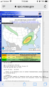
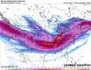
The new shortwave is well to the north..that is what is pulling everything north. Will be watching to see if that new shortwave begins further south...see the animation below....watch for the yellow. If that starts further south and earlier..the threat will expand.
The scenario I described is unlikely and we would begin to see a change this morning. I think the SPC has a good handle on things...but if something were to change- it would have to happen very soon.Around what time should be know that answer? How much lead time?
Gotcha... I guess the main thing I will be curious to see is if the models are underdoing the CAPEThe scenario I described is unlikely and we would begin to see a change this morning. I think the SPC has a good handle on things...but if something were to change- it would have to happen very soon.
Good point... that’s one thing models can and tend to under estimate...Gotcha... I guess the main thing I will be curious to see is if the models are underdoing the CAPE


How would you feel about east of Murfreesboro by 40 miles? I am further north then AL that’s why I am asking12z nam has the jet pulling away at 3am...boy that is close for say the I59 corridor, CAPE is rapidly building then.
Sunny hereSo the crapvection to this point is non-existent. Watch for cloud breaks because if this happens things will change for the target area
yeah. That being said. Warm air is surging north pretty fast ...that push dew points up oretty quickSo the crapvection to this point is non-existent. Watch for cloud breaks because if this happens things will change for the target area
Any where in the SPC ENH zone is a significant threat.How would you feel about east of Murfreesboro by 40 miles? I am further north then AL that’s why I am asking