
Navigation
Install the app
How to install the app on iOS
Follow along with the video below to see how to install our site as a web app on your home screen.
Note: This feature may not be available in some browsers.
More options
-
Welcome to TalkWeather! We see you lurking around TalkWeather! Take the extra step and join us today to view attachments, see less ads and maybe even join the discussion. CLICK TO JOIN TALKWEATHER
You are using an out of date browser. It may not display this or other websites correctly.
You should upgrade or use an alternative browser.
You should upgrade or use an alternative browser.
MattPetrulli
Member
Complicated signature, seems like a tornado going right into Columbia however.
I hope there's no tornado actually down there. My sister (who will graduate from high school a few months from now) has been looking at going to the University of South Carolina. If the campus gets wrecked, I don't want to see her reaction to the bad news...
Shakespeare2016
Member
Wasn't there even a couple of pretty deadly EF3's from that historic day?For sure, in fact most of the deaths on 4/27/2011 were caused by just five tornadoes (Hackleburg/Phil Campbell, Tuscaloosa, Rainsville, Smithville, and Ohatchee/Piedmont). The Hackleburg/Phil Campbell tornado alone caused more deaths than an average year, and didn't even hit any major cities (to my knowledge the biggest town it hit was Tanner).
SilentShadow87
Member
There were a few, yes. The Sawyerville tornado in particular killed around 10 people if I recall correctly.Wasn't there even a couple of pretty deadly EF3's from that historic day?
Bama Ravens
Member
So would this be the deadliest tornado event in Alabama since April 27th?
Equus
Member
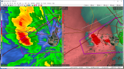
Nasty couplet headed for Bainbridge
Shakespeare2016
Member
The EF4 tornado that went through parts of Tennessee into Ringgold, Georgia killed 20 people on that historic day.There were a few, yes. The Sawyerville tornado in particular killed around 10 people if I recall correctly.
SilentShadow87
Member
Looking that way, yeah. Were the 10 deaths in Lee County from one tornado or two, by the way? If it was just one then it would be the deadliest tornado in the US since Vilonia.So would this be the deadliest tornado event in Alabama since April 27th?
Equus
Member
Death toll in Lee county up to 14 according to sheriff...
Been following this from elsewhere, but man what a day. I think one thing this tells us (along with several other setups in recent years) is to always be weary of potentials with westerly/zonal 500 mb flow in the SE. These subtle waves can lead to some very serious tornado events in this area. Last year on 3/19 (Jacksonville) and 3/15/08 (GA/SC outbreak) are two prime examples.
With that said, despite the high resolution models really going to town with this, I did not expect the type of widespread destruction today brought and a tornado of the caliber of the Lee County one. We may have already exceeded last year's tornado fatality count for the entire country in one county on one day alone. That was probably the strongest radar signature I've seen since the Elmer/Tipton tornado in OK in 2015. My condolences to everyone down there. Would not be shocked if we wind up with at least a few EF3+ tornadoes here (Eufaula, Beauregard and Talbotton immediately come to mind based on the damage pictures I've seen), and the Lee County tornado looks to have a good shot at EF4.
With that said, despite the high resolution models really going to town with this, I did not expect the type of widespread destruction today brought and a tornado of the caliber of the Lee County one. We may have already exceeded last year's tornado fatality count for the entire country in one county on one day alone. That was probably the strongest radar signature I've seen since the Elmer/Tipton tornado in OK in 2015. My condolences to everyone down there. Would not be shocked if we wind up with at least a few EF3+ tornadoes here (Eufaula, Beauregard and Talbotton immediately come to mind based on the damage pictures I've seen), and the Lee County tornado looks to have a good shot at EF4.
Now the deadliest single tornado in the US since the Vilonia tornado in 2014 (16), if it was all from the initial one that is.
To go along with what Andy mentioned , a few things I'm personally reminded of following this event:
1. Watch for situations where bulk shear vectors don't back behind initiating surface(s) - katafront. Outbreaks don't always work in this manner, however it certainly adds an additional layer of confidence when observed. DPVA is of a special kind when this occurs.
2. The presence of storm relative helicity is strictly a necessary yet insufficient item within the tornadogenesis process. Often seemingly meaningless details in the storm relative wind profile throughout the depth of the cloud bearing layer are, and always will be, king. However, the wind profile entity is what controls the storm relative flow via storm motion, and thus the ground relative/storm relative puzzle results. Buoyancy acts as clay and wind shear the potter, so many possible resultant shapes and sizes.
3. Ingredients-based forecasting is crucial in our field. It absolutely does not matter if there has never been a tornado outbreak associated with a surface low in lower-middle Alabama, if the atmospheric parameters indicate tornadoes, then a tornado forecast it is.
4. The exit region of upper jets in general is an excellent place for tornado outbreaks. Most times, it is best not to place emphasis on jet quadranting for many reasons, but rather on the presence of diffluence which overpowers speed convergence - which in today's case consisted of a nosing upper jet over top the western edge of the warm sector air mass.
We study a fascinating, powerful, and humbling science, and I just hate that we lost people today in this outbreak...
Casie
Member
Tallahassee now under the gun! Geez!
Equus
Member
TDS on that... heading ESE for Tallahassee. It just doesn't stop.
Casie
Member
Confirmed damage in Quincy per TWC on that storm.