jmills
Member
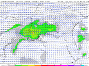
Over the past day or two, the Euro has been consistent in depicting an embedded shortwave with associated surface cyclogenesis across AL/GA on Sunday. A broad warm sector spreads across the area and with a good amount of shear, it looks like severe weather, including tornadoes, is a good bet. The other synoptic models have generally been in their own world, but they are converging towards the Euro's solution.
Since SPC has introduced a risk area for the threat, I'd thought it'd be a good idea to start this thread to keep the general severe wx thread from getting cluttered.

Since SPC has introduced a risk area for the threat, I'd thought it'd be a good idea to start this thread to keep the general severe wx thread from getting cluttered.
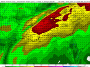
...ECMWF has been the most consistent model generating a surface low
over the Arklatex immediately ahead of a surging arctic front. This
feature will be induced by a pronounced mid-level short-wave trough
that is forecast to translate across the lower MS Valley through the
Mid-South by Sunday evening. Latest guidance suggests higher-PW air
mass should advance to near the TN border ahead of the surface wave
which should allow a broad warm sector to materialize prior to
frontal passage. It appears strong-severe organized convection could
develop ahead of the short wave as strong shear and adequate
buoyancy will be in place prior to convective development...
Last edited: