
Ugh yeah I noticed. Not sure why it’s doing that. I’ll try to fix it once I’m off work.It looks like a bunch of the photos you uploaded aren't showing up, at least on my end. Not sure why.
Anyways, from what I've heard Antlers seems to have been Jarrell-esque in places but it's hard to ascertain its intensity with the paucity of visual documentation.
Navigation
Install the app
How to install the app on iOS
Follow along with the video below to see how to install our site as a web app on your home screen.
Note: This feature may not be available in some browsers.
More options
-
Welcome to TalkWeather! We see you lurking around TalkWeather! Take the extra step and join us today to view attachments, see less ads and maybe even join the discussion. CLICK TO JOIN TALKWEATHER
You are using an out of date browser. It may not display this or other websites correctly.
You should upgrade or use an alternative browser.
You should upgrade or use an alternative browser.
Significant Tornado Events
- Thread starter locomusic01
- Start date
Juliett Bravo Kilo
Member
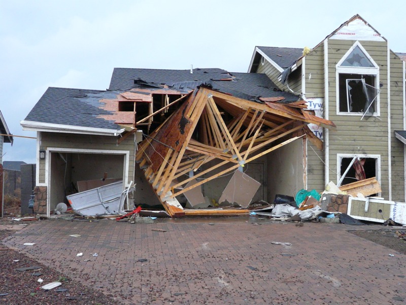
Interesting another Arizona outbreak, the only outbreak I knew of is the October 6, 2010 one.One tornado outbreak that isn't talked about much is the June 21 1972 Central Arizona tornado outbreak. At least 7 tornadoes touched down, the strongest being an F3 that affected the town of Eloy. This short-lived 1000 yard wide tornado tore through the town, completely destroying two homes and several businesses. 18 people were injured and the town struggled to clean up after the tornado.
View attachment 5843
View attachment 5844
View attachment 5845
View attachment 5846
View attachment 5847
View attachment 5848
October 2010 Arizona tornado outbreak - Wikipedia
 en.wikipedia.org
Arizona Tornado Outbreak – October 6, 2010 – Tornado Talk
Marshal79344
Member
Aerials from the Antlers Tornado of 1945


More Antlers Damage I have in my archives


More Antlers Damage I have in my archives
Juliett Bravo Kilo
Member
Those aerials demonstrate some pretty intense wind-rowing and debris granulation. Reminds me of Jarrell quite a bit.Aerials from the Antlers Tornado of 1945
View attachment 5851View attachment 5852View attachment 5853
More Antlers Damage I have in my archives
View attachment 5854View attachment 5855View attachment 5856
The damage pattern showed multi vortex character.Aerials from the Antlers Tornado of 1945
View attachment 5851View attachment 5852View attachment 5853
More Antlers Damage I have in my archives
View attachment 5854View attachment 5855View attachment 5856
Marshal79344
Member
Unfortunately, the vegetation damage the tornado caused wasn't really a focus of most photographers at the time but there are a few pictures that indicate it was on the level or worse than the other F5's recorded in the general region
View attachment 4271
View attachment 4272
Again, note the narrow transition zone
View attachment 4273
Courtesy of the Detroit Public Library digital collection and the Midland County Historical Society
I had been doing some research regarding the 1953 Flint Tornado recently and came across this stunning photo of a completely debarked treeUnfortunately, the vegetation damage the tornado caused wasn't really a focus of most photographers at the time but there are a few pictures that indicate it was on the level or worse than the other F5's recorded in the general region
View attachment 4271
View attachment 4272
Again, note the narrow transition zone
View attachment 4273
Courtesy of the Detroit Public Library digital collection and the Midland County Historical Society

One unusual thing I find about the Flint Tornado is how sharp and narrow the damage intensity contour was. This is usually observed in very fast-moving tornadoes, such as Harrisburg 2012, Guin 1974, and Hackleburg, but almost never in tornadoes moving at 35 mph. Aerials from the worst-hit area clearly show a very narrow strip, no more than two blocks wide, of all-out F5 damage. Given the intensities from most of the other tornadoes that day, this tornado's very narrow strip of F5 damage makes me think that the conservation of angular momentum played a part in its phenomenal intensity.


The Flint tornado first appeared to be of a Cullman-Type structure, a narrow, multiple-vortex tornado. The tornado quickly increased in intensity, and grew into a Chapman 2016 type funnel, with power flashes lighting it up from time to time, and horizontal vortices sticking out of the funnel, a sign of an extremely violent tornado. The roar generated by the Flint Tornado was so loud that several of the survivors said that they couldn't think and that it made the ground move. The tornado came with little to no warning, and due to tornadoes of such incredible intensity being very rare in Michigan, I believe that several people in Coldwater Road, despite the tornado's rather slow movement (35 mph) did not actually think that the massive roar was a tornado. Some survivors remember being blasted out of their homes, literally eating dinner, and being thrown across the street without taking any protective action whatsoever. It's likely that this belief may have significantly contributed to the loss of life.
Another factor that I believe may have significantly contributed to the loss of life in the Flint Tornado was the drive-in theater. Many people who were watching a movie, and able to see the tornado coming (the funnel of the Flint Tornado was rather visible and not obscured much based on all available accounts) attempted to flee the tornado in their cars. Many people decided to flee, and actually ended up driving right into the tornado, resulting in many unneeded deaths. Had they stayed put, they would've been fine as the drive-in theater sustained EF0-EF1 damage at the most, but the decision made by many to move makes me think that the condensation funnel of the Flint Tornado contained F4-F5 winds in the very center along a narrow swath, and contained very weak winds on the outside, appearing as a larger than average tornado. A duo was sucked up into the tornado, and lost consciousness. When they came to, they were 6 blocks away (I think). I remember seeing another photo of a car that was just horrifically mutilated (reminds me of that red-colored vehicle hit by the 2011 El Reno Tornado, NOT the two photos pictured below).


The tornado's effects dramatically (and thankfully) lessened as the tornado moved further along Coldwater Road, which makes me think that the violent and narrow strip of F5 damage expanded, resulting in weakening due to the circulation becoming less defined. The tornado continued to produce significant damage through Flint, but resulted in no more than five fatalities after it had left the heavy loss area (At least 111 bodies were counted in the worst-hit area).
Juliett Bravo Kilo
Member
Concerning Flint:I had been doing some research regarding the 1953 Flint Tornado recently and came across this stunning photo of a completely debarked tree
View attachment 5857
One unusual thing I find about the Flint Tornado is how sharp and narrow the damage intensity contour was. This is usually observed in very fast-moving tornadoes, such as Harrisburg 2012, Guin 1974, and Hackleburg, but almost never in tornadoes moving at 35 mph. Aerials from the worst-hit area clearly show a very narrow strip, no more than two blocks wide, of all-out F5 damage. Given the intensities from most of the other tornadoes that day, this tornado's very narrow strip of F5 damage makes me think that the conservation of angular momentum played a part in its phenomenal intensity.
View attachment 5858
View attachment 5859
The Flint tornado first appeared to be of a Cullman-Type structure, a narrow, multiple-vortex tornado. The tornado quickly increased in intensity, and grew into a Chapman 2016 type funnel, with power flashes lighting it up from time to time, and horizontal vortices sticking out of the funnel, a sign of an extremely violent tornado. The roar generated by the Flint Tornado was so loud that several of the survivors said that they couldn't think and that it made the ground move. The tornado came with little to no warning, and due to tornadoes of such incredible intensity being very rare in Michigan, I believe that several people in Coldwater Road, despite the tornado's rather slow movement (35 mph) did not actually think that the massive roar was a tornado. Some survivors remember being blasted out of their homes, literally eating dinner, and being thrown across the street without taking any protective action whatsoever. It's likely that this belief may have significantly contributed to the loss of life.
Another factor that I believe may have significantly contributed to the loss of life in the Flint Tornado was the drive-in theater. Many people who were watching a movie, and able to see the tornado coming (the funnel of the Flint Tornado was rather visible and not obscured much based on all available accounts) attempted to flee the tornado in their cars. Many people decided to flee, and actually ended up driving right into the tornado, resulting in many unneeded deaths. Had they stayed put, they would've been fine as the drive-in theater sustained EF0-EF1 damage at the most, but the decision made by many to move makes me think that the condensation funnel of the Flint Tornado contained F4-F5 winds in the very center along a narrow swath, and contained very weak winds on the outside, appearing as a larger than average tornado. A duo was sucked up into the tornado, and lost consciousness. When they came to, they were 6 blocks away (I think). I remember seeing another photo of a car that was just horrifically mutilated (reminds me of that red-colored vehicle hit by the 2011 El Reno Tornado, NOT the two photos pictured below).
View attachment 5860
View attachment 5861
The tornado's effects dramatically (and thankfully) lessened as the tornado moved further along Coldwater Road, which makes me think that the violent and narrow strip of F5 damage expanded, resulting in weakening due to the circulation becoming less defined. The tornado continued to produce significant damage through Flint, but resulted in no more than five fatalities after it had left the heavy loss area (At least 111 bodies were counted in the worst-hit area).
Some previous postings on it:
Significant Tornado Events
Looks like there was a significant tornado in Mongolia yesterday. 30 injuries, including 3 critical. Again showing that China is likely much more active tornado wise than previously though. I would love to hear from some of our posters in China if they have any info about this event!
Time for my contributions on Flint:
These first two show that low-lying shrubs were completely stripped:


This next one is an aerial of the devastation, every single one of the 40 homes was swept completely clean:

Another aerial demonstrating that the tornado had a complex multivortex structure:

A video of aftermath footage from Flint, contains a huge amount of wrecked and mangled cars:
I found all these pics from stormstalker, which provide an excellent write up of the 1953 outbreak in America, the deadliest post-radar until 2011: https://stormstalker.wordpress.com/2013/09/05/flint-worcester-outbreak/
The admin of this site used to post under the name 'locomusic01' not sure if he's still around anymore or not.
Marshal79344
Member
It's been 13 years since one of the worst tornado outbreaks unfolded, with incredibly deadly fury, across the Southern Ohio Valley, Ozarks, and parts of Dixie Alley. The tornado outbreak was triggered by an eastward-moving surface low, which was interacting with warm, unstable air that had gradually wafted northwards over the past few days. On the evening of February 4th, there was already enough instability to support severe thunderstorms, and a Slight Risk of severe weather had been issued, but luckily, there was no forcing or trigger for supercell thunderstorms to develop. That trigger came on February 5th with the surface low. The surface low created favorable wind profiles for tornadoes, and coming with it came the trigger, the approaching cold front. The cold front triggered a lot of forcing in the warm sector, coupled with a very strong jet streak aiding in open warm sector development as well, which caused the formation of numerous discrete supercell thunderstorms, which brought the deadly tornado outbreak. This particular trough displayed a clear, negative tilt to it, a classic signature of many other major tornado-producing troughs.

Surface Analysis as the Tornado Outbreak was in progress, notice how there is a lot of southeast winds at the surface, which suggests strong low-level veering. You can also see temperatures and dewpoints favoring severe weather, most of them in the 70-60 range. The temperature-dewpoint spread was also not too big, which meant that the lower-level profile was very moist, which, as a result, favored supercell thunderstorms of a higher than normal precipitation complexion, which would make some tornadoes difficult to see. At this point, the Clinton, AR long-tracked EF4 was in progress in Central Arkansas. The supercell that would produce the EF2 tornado at Memphis (and later the EF4 at Union University in Jackson, Tennessee) was maturing into a supercell. A squall line, created by enhanced forcing along the cold front, was present in Arkansas, riding the cold front.

Sounding from 0000 UTC at Little Rock, as the long-tracked Clinton, Arkansas EF4 Tornado was in progress. You can see decent instability values for this time of year, along with strong lapse rates slightly enhanced by a tiny touch of dry air at the surface. This may have resulted in the rather more visible nature (much more visible than the other tornadic supercells that day) of the Clinton, Arkansas Supercell. Looking at the hodograph, you can see the presence of a VERY STRONG upper-level jet streak, aiding in discrete supercell development in the open warm sector. A Critical Angle of 47 degrees can also be seen, which favors long-tracked, steady-state tornadoes. The Critical Angle was much higher in southern Tennessee, where the tornadic supercell activity was much more cyclic. Strong wind shear and Storm Relative Helicity (SRH) can also be seen.

The supercell that produced the long-tracked Arkansas Tornado was the first to form and dropped the tornado less than an hour after echo tops had initially reached 40,000 feet. This tornado remained in a very steady state for its entire life, taking on the appearance of a strong stovepipe. Horizontal Vortices were also observed with this tornado. The tornado finally dissipated after the supercell was overtaken by some convection, after remaining steady for 121.84 miles.

The tornado first formed to the southeast of Atkins and rapidly intensified. While the tornado was not big when it approached the Atkins area, it had already attained EF3 (officially, likely EF4) intensity. It killed a woman in a mobile home park along a lake, before it entered more populated areas, due east of Atkins. Several homes in this area were obliterated and swept away, all of which were not anchored properly, preventing a rating of higher than EF3. This is a very hard tornado for me in particular. I used to be a fan of the Warrior Cats book series, and so was Emmy Cherry, the 10-year-old daughter of Jimmy and Dana Cherry, who all perished in Atkins. Emmy loved Warriors so much that she had bought every single book, had every type of merchandise, and wrote many book reports on the books. She was also very terrified of storms, which makes me very sad about her final moments, in which she likely heard the very loud roar of the approaching tornado. It must have been a horrific experience, one that I would never wish upon my worst enemy. In her honor, her friends wrote the author of the Warrior Cats series, and she was very moved by her story. The author created three new cats in the book in her and her parent's memory.
The remains of the Cherry Family Home after the tornado. Notice how there is little to no anchoring visible on the foundation of the home:

The reason I believe that this tornado was already violent in the Atkins area is due to the debarking of this hardwood tree, which is on a level very similar to other violent tornadoes.

The tornado was photographed in the Atkins area:

Surface Analysis as the Tornado Outbreak was in progress, notice how there is a lot of southeast winds at the surface, which suggests strong low-level veering. You can also see temperatures and dewpoints favoring severe weather, most of them in the 70-60 range. The temperature-dewpoint spread was also not too big, which meant that the lower-level profile was very moist, which, as a result, favored supercell thunderstorms of a higher than normal precipitation complexion, which would make some tornadoes difficult to see. At this point, the Clinton, AR long-tracked EF4 was in progress in Central Arkansas. The supercell that would produce the EF2 tornado at Memphis (and later the EF4 at Union University in Jackson, Tennessee) was maturing into a supercell. A squall line, created by enhanced forcing along the cold front, was present in Arkansas, riding the cold front.
Sounding from 0000 UTC at Little Rock, as the long-tracked Clinton, Arkansas EF4 Tornado was in progress. You can see decent instability values for this time of year, along with strong lapse rates slightly enhanced by a tiny touch of dry air at the surface. This may have resulted in the rather more visible nature (much more visible than the other tornadic supercells that day) of the Clinton, Arkansas Supercell. Looking at the hodograph, you can see the presence of a VERY STRONG upper-level jet streak, aiding in discrete supercell development in the open warm sector. A Critical Angle of 47 degrees can also be seen, which favors long-tracked, steady-state tornadoes. The Critical Angle was much higher in southern Tennessee, where the tornadic supercell activity was much more cyclic. Strong wind shear and Storm Relative Helicity (SRH) can also be seen.
The supercell that produced the long-tracked Arkansas Tornado was the first to form and dropped the tornado less than an hour after echo tops had initially reached 40,000 feet. This tornado remained in a very steady state for its entire life, taking on the appearance of a strong stovepipe. Horizontal Vortices were also observed with this tornado. The tornado finally dissipated after the supercell was overtaken by some convection, after remaining steady for 121.84 miles.
The tornado first formed to the southeast of Atkins and rapidly intensified. While the tornado was not big when it approached the Atkins area, it had already attained EF3 (officially, likely EF4) intensity. It killed a woman in a mobile home park along a lake, before it entered more populated areas, due east of Atkins. Several homes in this area were obliterated and swept away, all of which were not anchored properly, preventing a rating of higher than EF3. This is a very hard tornado for me in particular. I used to be a fan of the Warrior Cats book series, and so was Emmy Cherry, the 10-year-old daughter of Jimmy and Dana Cherry, who all perished in Atkins. Emmy loved Warriors so much that she had bought every single book, had every type of merchandise, and wrote many book reports on the books. She was also very terrified of storms, which makes me very sad about her final moments, in which she likely heard the very loud roar of the approaching tornado. It must have been a horrific experience, one that I would never wish upon my worst enemy. In her honor, her friends wrote the author of the Warrior Cats series, and she was very moved by her story. The author created three new cats in the book in her and her parent's memory.
The remains of the Cherry Family Home after the tornado. Notice how there is little to no anchoring visible on the foundation of the home:
The reason I believe that this tornado was already violent in the Atkins area is due to the debarking of this hardwood tree, which is on a level very similar to other violent tornadoes.
The tornado was photographed in the Atkins area:
Marshal79344
Member
The tornado continued to produce very severe tree damage as it roared towards the city of Clinton, leaving a noticeable scar on satellite imagery (seen below. The city of Scotland was directly impacted by a tornado of slightly lower intensity two years after this tornado)

The tornado matured into a large stovepipe tornado during this phase of the path, which it would remain for the rest of its life. The tornado leveled several homes in this area, but none were warranting of an EF4 rating. The first area of EF4 damage finally occurred as the tornado devastated the south side of Clinton, mutilating a boat factory, killing a man inside. A dentist's office was leveled. Several homes were swept away and wind-rowed. Trees sustained debarking.


The tornado displayed a horizontal vortex in the Clinton area too!

Just northeast of Clinton, a well-built home was completely leveled at EF4 intensity. A car at this home was never found. Trees nearby were also debarked. The tornado completely denuded and debarked a grove of trees in this area too.
Tree Damage in this area

The tornado continued to produce EF4 damage as it hit the southern side of Mountain View, AR, where several businesses were leveled. It continued towards the Zion community, where it impacted several mobile homes at EF3 (likely EF4 again) intensity. The car damage in this area was simply insane.


The tornado quickly dissipated soon afterwards, as the parent supercell was finally overtaken by strong convection. However, more supercells were maturing in the open warm sector further east (I will post about these tornadoes later)
The tornado matured into a large stovepipe tornado during this phase of the path, which it would remain for the rest of its life. The tornado leveled several homes in this area, but none were warranting of an EF4 rating. The first area of EF4 damage finally occurred as the tornado devastated the south side of Clinton, mutilating a boat factory, killing a man inside. A dentist's office was leveled. Several homes were swept away and wind-rowed. Trees sustained debarking.
The tornado displayed a horizontal vortex in the Clinton area too!
Just northeast of Clinton, a well-built home was completely leveled at EF4 intensity. A car at this home was never found. Trees nearby were also debarked. The tornado completely denuded and debarked a grove of trees in this area too.
Tree Damage in this area
The tornado continued to produce EF4 damage as it hit the southern side of Mountain View, AR, where several businesses were leveled. It continued towards the Zion community, where it impacted several mobile homes at EF3 (likely EF4 again) intensity. The car damage in this area was simply insane.
The tornado quickly dissipated soon afterwards, as the parent supercell was finally overtaken by strong convection. However, more supercells were maturing in the open warm sector further east (I will post about these tornadoes later)
CheeselandSkies
Member
The Super Tuesday outbreak was probably the most impressive and violent (certainly the deadliest) tornado outbreak of the 21st Century until 4/27. The Atkins-Clinton tornado was another one of those tornadoes that, like Vilonia '14, was probably capable of EF5 damage in Arkansas. Unlike Vilonia though, it didn't really produce any instances of clear-cut EF5 damage that was deliberately lowballed by surveyors.
The track length is also right up there with other VLT Ozarks/Dixie tornadoes like Hackleburg and Yazoo City '10.
The track length is also right up there with other VLT Ozarks/Dixie tornadoes like Hackleburg and Yazoo City '10.
Last edited:
Juliett Bravo Kilo
Member
More pics from Clinton, AR:
1. Another view of the mangled Jeep. Standing in front of the jeep is Dan Koch, Information Technology Officer (ITO) at the National Weather Service in Little Rock:

2. License plate embedded in a tree trunk:

3. Remains of a pickup truck

4. The remains of the dentist's office

5. Mangled cars and trucks (presumably from the dealership):

6. A Hummer that was thrown around a quarter mile from a residence near Zion, AR:

Sources:
https://www.weather.gov/lzk/svr0208ayr.htm (lots of pics can be found in links here):
 www.tornadotalk.com
 www.4029tv.com
1. Another view of the mangled Jeep. Standing in front of the jeep is Dan Koch, Information Technology Officer (ITO) at the National Weather Service in Little Rock:
2. License plate embedded in a tree trunk:
3. Remains of a pickup truck
4. The remains of the dentist's office
5. Mangled cars and trucks (presumably from the dealership):
6. A Hummer that was thrown around a quarter mile from a residence near Zion, AR:
Sources:
https://www.weather.gov/lzk/svr0208ayr.htm (lots of pics can be found in links here):
Arkansas Long-Track EF4 Tornado – February 5, 2008 – Tornado Talk

President Bill Clinton to join tour of tornado damage
President Bill Clinton will join state and national leaders to survey the damage left after an EF-4 tornado ravaged parts of Central Arkansas.
www.4029tv.com
Juliett Bravo Kilo
Member
The structure on the Bridgeport, AL EF4 is incredible. Out of curiosity, why do so many of the storms in Dixie Alley have such low-hanging cloud bases compared to their Great Plains counterparts?Some rare 4.27 photos I've found
End of the Cullman Tornado. The tornado dissipated immediately after it had finished crossing this river.
View attachment 5815
The formation of the Flat Rock Tornado
View attachment 5816
The formation of the Rainsville Tornado
View attachment 5817
The Ringgold Tornado at EF4 strength in the Apison, TN area
View attachment 5818
A view under the wall cloud of the Bridgeport, AL EF4
View attachment 5819
The Hackleburg Tornado near the Carter Gin Subdivision (the final area of EF4+ damage along the path)
View attachment 5820
The Cordova Tornado's wall cloud structure
View attachment 5821
The Shoal Creek Tornado approaching the Ohatchee area
View attachment 5822
A view of the Rainsville Tornado in its mature stage, as seen from Fort Payne, AL
View attachment 5824
The horrific Tuscaloosa Tornado
View attachment 5825
MNTornadoGuy
Member
In June 2017, two major tornado outbreaks affected an unusual area, the Ural Mountains in Russia. The first outbreak (6/3/17) was the largest with 28 tornadoes across the Ural Mountains region. The strongest of the tornadoes from this outbreak was Visim F3. This massive mile-wide tornado completely destroyed over 1228 acres of forest with over 80% of trees being blown down in some spots. >3 other significant tornadoes were produced by this outbreak.


Information about the tornado
-
The second outbreak occurred 15 days later on June 18th. This outbreak was smaller and less widespread but was more significant with 3 F2s and one F4 occurring. This massive tornado ripped through the village of Maloye Pes’yanovo completely leveling four homes and debarking trees. This was the first violent Russian tornado in the 21st century.
.png")
.png")

Information about the tornado
-
The second outbreak occurred 15 days later on June 18th. This outbreak was smaller and less widespread but was more significant with 3 F2s and one F4 occurring. This massive tornado ripped through the village of Maloye Pes’yanovo completely leveling four homes and debarking trees. This was the first violent Russian tornado in the 21st century.
Attachments
Juliett Bravo Kilo
Member
It seems like quite a bit of the Upper Midwest tornadoes are often very narrow and have sharp damage contours, and are incredibly violent. The Hudsonville, MI tornado of 1956 is another impressive event in that region. It was also surprisingly well-documented for its time.I had been doing some research regarding the 1953 Flint Tornado recently and came across this stunning photo of a completely debarked tree
View attachment 5857
One unusual thing I find about the Flint Tornado is how sharp and narrow the damage intensity contour was. This is usually observed in very fast-moving tornadoes, such as Harrisburg 2012, Guin 1974, and Hackleburg, but almost never in tornadoes moving at 35 mph. Aerials from the worst-hit area clearly show a very narrow strip, no more than two blocks wide, of all-out F5 damage. Given the intensities from most of the other tornadoes that day, this tornado's very narrow strip of F5 damage makes me think that the conservation of angular momentum played a part in its phenomenal intensity.
View attachment 5858
View attachment 5859
The Flint tornado first appeared to be of a Cullman-Type structure, a narrow, multiple-vortex tornado. The tornado quickly increased in intensity, and grew into a Chapman 2016 type funnel, with power flashes lighting it up from time to time, and horizontal vortices sticking out of the funnel, a sign of an extremely violent tornado. The roar generated by the Flint Tornado was so loud that several of the survivors said that they couldn't think and that it made the ground move. The tornado came with little to no warning, and due to tornadoes of such incredible intensity being very rare in Michigan, I believe that several people in Coldwater Road, despite the tornado's rather slow movement (35 mph) did not actually think that the massive roar was a tornado. Some survivors remember being blasted out of their homes, literally eating dinner, and being thrown across the street without taking any protective action whatsoever. It's likely that this belief may have significantly contributed to the loss of life.
Another factor that I believe may have significantly contributed to the loss of life in the Flint Tornado was the drive-in theater. Many people who were watching a movie, and able to see the tornado coming (the funnel of the Flint Tornado was rather visible and not obscured much based on all available accounts) attempted to flee the tornado in their cars. Many people decided to flee, and actually ended up driving right into the tornado, resulting in many unneeded deaths. Had they stayed put, they would've been fine as the drive-in theater sustained EF0-EF1 damage at the most, but the decision made by many to move makes me think that the condensation funnel of the Flint Tornado contained F4-F5 winds in the very center along a narrow swath, and contained very weak winds on the outside, appearing as a larger than average tornado. A duo was sucked up into the tornado, and lost consciousness. When they came to, they were 6 blocks away (I think). I remember seeing another photo of a car that was just horrifically mutilated (reminds me of that red-colored vehicle hit by the 2011 El Reno Tornado, NOT the two photos pictured below).
View attachment 5860
View attachment 5861
The tornado's effects dramatically (and thankfully) lessened as the tornado moved further along Coldwater Road, which makes me think that the violent and narrow strip of F5 damage expanded, resulting in weakening due to the circulation becoming less defined. The tornado continued to produce significant damage through Flint, but resulted in no more than five fatalities after it had left the heavy loss area (At least 111 bodies were counted in the worst-hit area).
I recommend this gallery, as it has every damage photo from this thing (and several of the tornado itself): https://www.flickr.com/photos/50000032@N03/page1
Some notable pics. Note the pronounced wind rowing & ground scouring and the automobile damage from this thing:


J-Rab
Member
It is because of the high humidity in Dixie Alley.The structure on the Bridgeport, AL EF4 is incredible. Out of curiosity, why do so many of the storms in Dixie Alley have such low-hanging cloud bases compared to their Great Plains counterparts?
It is easy to see on a skew-T chart because the LCL (Lifting Condensation Level) is found by the intersection of a dry adiabat up from the surface temperature and a saturation mixing ratio line up from the surface dew point. The closer the surface dew point is to the surface temperature, the lower the intersection will be on the chart, and the lower the cloud base is. (LCL is a pretty close approximation to the cloud base)
Obviously, in a dryer environment, the dew point and the temperature are much further apart on the skew-T and the intersection of the two lines will be higher in the atmosphere. That’s why many of the tornadoes in places like Arizona for instance, will have a much higher cloud base.
At least that is my understanding.
I'm not entirely convinced that Tupelo was a warm frontal event. Perhaps along an old outflow boundary (something like 4/27/11 perhaps), but there were major tornadoes to the north in Tennessee that day as well, which would go against the idea of the warm sector's northward extent being cut off in MS/AL.
Also those color damage photos of it and Antlers are pretty incredible. Not going to find many more convincing arguments for an F5 back then apart from a few others.
Also those color damage photos of it and Antlers are pretty incredible. Not going to find many more convincing arguments for an F5 back then apart from a few others.
Last edited:
Not to pump my own tires too much (especially since Grazulis did most of the work), but y'all should probably check this out.
Juliett Bravo Kilo
Member
Not to pump my own tires too much (especially since Grazulis did most of the work), but y'all should probably check this out.
Out of curiosity, did you once access to a map that demonstrated similarities in F4+ VLT tornadoes that went through Dixie Alley going back to the 1920s or something? Maybe another use did, not sure. I'd really like to find that map again, assuming you know how to find it.
I don't believe so.Out of curiosity, did you once access to a map that demonstrated similarities in F4+ VLT tornadoes that went through Dixie Alley going back to the 1920s or something? Maybe another use did, not sure. I'd really like to find that map again, assuming you know how to find it.
Juliett Bravo Kilo
Member
Never mind, my bad. Someone else did, I wish I could the chart again, it was incredible. It was paths of 1974 and 2011 Super Outbreak F4+ tornadoes and the similarities between them. They also added a long-track wedge from April 20, 1920 that took a path virtually identical to Hackleburg through Alabama. It was spooky how so close many of the paths were, the exact same addresses, intersections, monuments and landmarks were struck decades apart by tornadoes of identical intensity.I don't believe so.