Navigation
Install the app
How to install the app on iOS
Follow along with the video below to see how to install our site as a web app on your home screen.
Note: This feature may not be available in some browsers.
More options
-
Welcome to TalkWeather! We see you lurking around TalkWeather! Take the extra step and join us today to view attachments, see less ads and maybe even join the discussion. CLICK TO JOIN TALKWEATHER
You are using an out of date browser. It may not display this or other websites correctly.
You should upgrade or use an alternative browser.
You should upgrade or use an alternative browser.
- Moderator
- #422
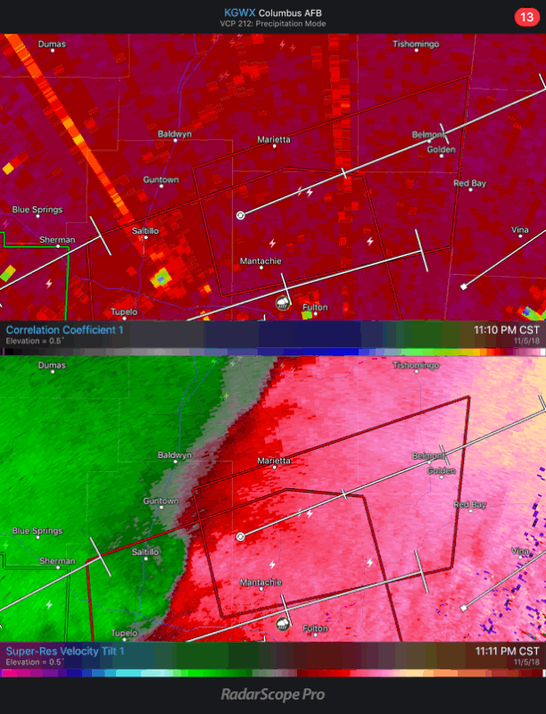
That TDS has traveled over populated areas for 3 scans. Hopefully this is just trees being lofted.
Most likely not. It definitely went over a lot of structural stuff. A lot of neighborhoods, and businesses.
BayouWeatherGeek
Member
bwalk
Member
Memphis NWS is saying “considerable damage” re the Tupelo storm so far.
BayouWeatherGeek
Member
Memphis NWS is saying “considerable damage” re the Tupelo storm so far.
The TDS looks like it went right over a shopping center according to TWC.
BayouWeatherGeek
Member
southmdwatcher
Member
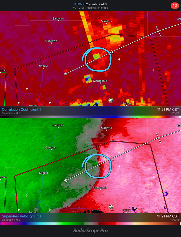
Unfortunately that TDS is still going strong.
Bama Ravens
Member
There is another circulation forming NE of the one that just produced the tornado near Tupelo.
bwalk
Member
Yes, that would be Barnes Crossing Mall. Hopefully the funnel passed to the north of the mall. That was the track but it could have gone over the mall.The TDS looks like it went right over a shopping center according to TWC.
weadjust
Member
I'm in Tupelo and all three of the WTVA channels went of the air about 45 minutes prior to the tornado. WTVA facebook page says the electrical transformer near the station was on fire causing them to be off the air.
We have lost power WTVA 9 News. We are still tracking this storm on Facebook LIVE.
A transformer caught fire in front of our building.
We hope to be live on air soon. Please, pass the word in case anyone is wondering why we are not on air and would like to watch.
We have lost power WTVA 9 News. We are still tracking this storm on Facebook LIVE.
A transformer caught fire in front of our building.
We hope to be live on air soon. Please, pass the word in case anyone is wondering why we are not on air and would like to watch.
southmdwatcher
Member
The circulation that Bama Ravens just pointed out also has a TDS now. Ugh
- Admin
- #433
- Messages
- 3,618
- Reaction score
- 3,431
- Location
- Fayetteville, AR
- Special Affiliations
- SKYWARN® Volunteer
THE NATIONAL WEATHER SERVICE IN MEMPHIS HAS ISSUED A
* TORNADO WARNING FOR...
NORTHERN ITAWAMBA COUNTY IN NORTHEASTERN MISSISSIPPI...
NORTHEASTERN LEE COUNTY IN NORTHEASTERN MISSISSIPPI...
SOUTHERN TISHOMINGO COUNTY IN NORTHEASTERN MISSISSIPPI...
SOUTHEASTERN PRENTISS COUNTY IN NORTHEASTERN MISSISSIPPI...
* UNTIL 1215 AM CST.
* AT 1122 PM CST, A LARGE AND EXTREMELY DANGEROUS TORNADO WAS LOCATED
NEAR SANDY SPRINGS, OR 10 MILES SOUTHEAST OF BALDWYN, MOVING EAST
AT 45 MPH.
THIS IS A PARTICULARLY DANGEROUS SITUATION. TAKE COVER NOW!
Bama Ravens
Member
New TDS NE of the previous one!
bwalk
Member
The ish is hitting the proverbial fan right now!
warneagle
Member
the line is moving through an incredibly strongly sheared environment right now, not at all surprising to see potentially significant tornadoes spinning up
- Admin
- #437
- Messages
- 3,618
- Reaction score
- 3,431
- Location
- Fayetteville, AR
- Special Affiliations
- SKYWARN® Volunteer
NWS has reported of semi overturned on I-22 near Tupelo
Bama Ravens
Member
Amazing how quickly these things spin up then seem to wind down quickly.
BayouWeatherGeek
Member
Flash flood warning for the Tupelo area.
Bama Ravens
Member
I got a grab of the first TDS going away and the new one popping up.