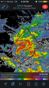
• Welcome to TalkWeather!
    We see you lurking around TalkWeather! Take the extra step and join us today to view attachments, see less ads and maybe even join the discussion.
    CLICK TO JOIN TALKWEATHER

Severe WX Severe Weather Threat 10/31-11/2

Now comes the time where everyone is watching the SPC convective outlook page like a hawk waiting,for it to update lol
 
With the NAM 3KM and the SREF showing 0-1KM SRH at 440-445( m2 s-2)over North Alabama between 19Z-21Z. That's up there. Will be watching for a spin up
 
Looks like the batch of storms will cut off moisture transport further north tomorrow. HRRR/NAM 3KM has a QLCS complex moving east along and south of I-20/59.

This was something I was concerned about precluding a larger threat further north. Still a damaging wind/tor threat along and south of 20/59.
 
A potential caveat I'm seeing across the more significant risk area today is too many storms going up and interacting with each other. That will have to be watched closely.
 
Expansion of the ENH risk. This looks particularly nasty for South/Central LA and into SW MS. There will be opportunity for discrete cells ahead of the main QLCS which will look to pose a tor/damaging wind threat itself.
 
Storms are starting to fire south of Houston. First tornado warning of the day issued.
 

Attachments

  • IMG_9822.PNG
    IMG_9822.PNG
    415.1 KB · Views: 0
Oh wow this could change things.. CAPE has been HORRIFICALLY underforecast according to SPC mesoanalysis when comparing to last night's model runs..
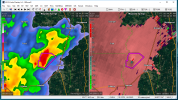
sbcape.conus.png


1541024907550.png
 
Yeah I'm really worried about Louisiana tonight, there could be some healthy supercells in front of the line.
 
Tornado warning on a discrete and very impressive looking supercell in TN near Jackson.

I'm getting worried this could be worse than advertised for areas north of I-20..
 
Back
Top