• Welcome to TalkWeather!
    We see you lurking around TalkWeather! Take the extra step and join us today to view attachments, see less ads and maybe even join the discussion.
    CLICK TO JOIN TALKWEATHER

Severe WX Severe Weather Event April 13-14, 2019

No PDS (70/60) and no mention of a High upgrade; SPC definitely far less enthusiastic on the day of the event than I figured they might be
 
Texas residents, when you’re not taking cover let us know you’re safe and what’s going on!
 
I get that there's still some uncertainty about storm coverage/mode but with a probable significant tornado already occurring, it seems like a slam dunk that a PDS would verify.
 
I've seen them replace an active SVR watch with a TOR watch, so maybe once stuff gets really going they'll pull an upgrade? I dunno. Just seems I've seen so many marginal outbreaks with PDS and High and they're being unusually conservative.
 
AREA FORECAST DISCUSSION
NATIONAL WEATHER SERVICE JACKSON MS
1131 AM CDT SAT APR 13 2019

...SEVERE WEATHER OUTBREAK THIS AFTERNOON THROUGH TONIGHT...

.UPDATE...
UPDATED FOR MORNING DISCUSSION.

&&

.DISCUSSION...

A SEVERE WEATHER OUTBREAK WITH THE POTENTIAL FOR STRONG TORNADOES
IS STILL EXPECTED AND NO SIGNIFICANT ADJUSTMENTS ARE PLANNED TO
THE CURRENT OUTLOOK GRAPHICS. THE WARM SECTOR HAS BEEN A BIT
SLOWER TO BUILD NORTHWARD THAN PRIOR GUIDANCE INDICATED WITH
RELATIVELY COOL, DENSE AIR WEDGING INTO THE DELTA REGION THIS
MORNING, HOWEVER, VERY STRONG HEIGHT/PRESSURE FALLS MIX THE WARM
FRONT NORTHWARD THIS AFTERNOON WITH A VERY FAVORABLE ENVIRONMENT
FOR TORNADIC SUPERCELLS QUICKLY TAKING SHAPE OVER THE DELTA
REGION AS ML CAPE INCREASES TO > 2500 J/KG AND EFFECTIVE SRH TO
~400 M2/S2 IN THE WARM SECTOR. THERE ARE UNCERTAINTIES WITH STORM
EVOLUTION AS MUCH OF THE NEAR TERM CAM GUIDANCE IS IN CONFLICT
CONCERNING INITIAL SUPERCELL DEVELOPMENT BOTH IN TERMS OF AREAL
COVERAGE AND MODE. SOME GUIDANCE SHOWS BROADER/GREATER COVERAGE
WITH HP SUPERCELL ACTIVITY WHILE SOME IS INDICATIVE OF MORE
DISCRETE AND CLASSIC SUPERCELL ACTIVITY. THESE UNCERTAINTIES WILL
KEEP US FROM INCREASING OUR CURRENT MESSAGING/THREAT LEVELS, WHICH
ARE ALREADY STRONG. OTHERWISE, WILL BE CONSIDERING ADJUSTMENTS IN
TIMING DEPENDING ON HOW CONVECTION EVOLVES INITIALLY, MOST LIKELY
TO SPEED THINGS UP SLIGHTLY. /EC/
 
It just seems that the uncertainty is more very dangerous vs extremely dangerous rather than marginal vs dangerous; I get being careful, with all the busts that have happened before, but this setup looks more impressive than most of those. Oh well. Gonna be a long day/night anyhow
 
I've seen them replace an active SVR watch with a TOR watch, so maybe once stuff gets really going they'll pull an upgrade? I dunno. Just seems I've seen so many marginal outbreaks with PDS and High and they're being unusually conservative.
I still am trying to wrap my head around the fact that 2/28/17 was a moderate risk and 4/2/17 was a high risk.
 
Yeah, there have been so many events with big potential but with caveats and it seems SPC's batting average with these is not great...when they go all-out HIGH/PDS things are a bit messier and when they play it conservative something like Beauregard happens.

Still, the overall message should be the same. Have a way to receive warnings and a plan for what to do if you're under one.
 
I remember multiple High Risks in the SE especially where the trigger was pulled despite significant concerns with storm mode, VBV, and only moderate low level helicity, and I just don't think today is the day to suddenly be conservative with the way the radar is already looking :p 
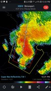
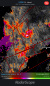
Maybe they're right and it wont be quite as bad as expected, but strong TDS signature before noon west of the MDT doesn't bode well
 
KLCH showing warm sector is decently free of junk convection to the south for now; given that stuff is already spinning hardcore before it even passes College Station, no doubt the big show later this evening is gonna get pretty nasty. I'm intrigued to see if any sustained highly developed supercells develop outside of the modeled broken line of supercells; those certainly have precedence in the MS Delta region in decades past of dropping high end long trackers.

For the sake of the small towns undoubtedly under the gun we can certainly hope broken lines of overly competing supercells or line segments prevails, as that would certainly help cut the track lengths and average intensities of tornadoes down a bit.
 
KLCH showing warm sector is decently free of junk convection to the south for now; given that stuff is already spinning hardcore before it even passes College Station, no doubt the big show later this evening is gonna get pretty nasty. I'm intrigued to see if any sustained highly developed supercells develop outside of the modeled broken line of supercells; those certainly have precedence in the MS Delta region in decades past of dropping high end long trackers.
Yeah, several infamous long-track tornadoes have crossed northern Louisiana into Mississippi along that general path, including the F5s in 1953 and 1971.
 
Not going to uncritically repeat scanner traffic but the damage reports from Franklin sound pretty serious. Major damage to homes and a lot of trees and power lines blocking rescue vehicles.
 
Radar doesn’t show rain moving out of North Alabama until 2pm today. Those that I have spoke with this morning said they’re going to bed like normal and aren’t concerned...
 
Back
Top