
Hey folks...chiming in from Bessemer. That was a pretty stout storm. Be careful out there NW Jefferson CountySIGNIFICANT WEATHER ADVISORY FOR SOUTHWESTERN JEFFERSON COUNTY
UNTIL 700 PM CDT...
At 629 PM CDT, Doppler radar was tracking a strong thunderstorm near
North Johns, or near Bessemer, moving north at 45 mph.
Pea size hail and winds in excess of 40 mph will be possible with
this storm.
Locations impacted include...
Southwestern Birmingham, Bessemer, Hueytown, Fairfield, Pleasant
Grove, Midfield, Adamsville, Brighton, Lipscomb, Sylvan Springs,
Mulga, Maytown, North Johns, Birmingham Fairgounds, Edgewater,
Ensley, Legion Field, Forestdale, Splash Adventure and Birmingham
Southern College.
Navigation
Install the app
How to install the app on iOS
Follow along with the video below to see how to install our site as a web app on your home screen.
Note: This feature may not be available in some browsers.
More options
-
Welcome to TalkWeather! We see you lurking around TalkWeather! Take the extra step and join us today to view attachments, see less ads and maybe even join the discussion. CLICK TO JOIN TALKWEATHER
You are using an out of date browser. It may not display this or other websites correctly.
You should upgrade or use an alternative browser.
You should upgrade or use an alternative browser.
Equus
Member
Lots of thunder here from those little cells marching NNW I presume with the warm front.
rolltide_130
Member
It’s going to be interesting over the next couple hours for North Alabama. You have those storms racing north on what I’m assuming is the warm front? You also have that rain shield marching east across North Mississippi that would put the brakes on major severe weather. The good news is maybe the threat won’t last all night
Rain shield is moving due N. It's just a question of what the storm mode is and where the warm front is by the time those storm in MS get here. I will say that supercell in MS is on a bad track for Huntsville..
I dont these storms are along the warm front. I believe they are a combination of low level convergence ahead of the low and diffluence aloft mixed with some instablity with little capping...the warm front should be fuether north of here.
Equus
Member
We're probably going to have a lot of those spinups as the line marches this way. Still have impressive low level shear. Am intrigued to see if anything happens ahead of the line in the warm sector otherwise we're going to have a QLCS-fest plus that echo that's causing the warnings thus far at the apex... and that echo isn't going to pass too far from here.
The environment over east Mississippi will start to change in a couple of hours as the upper low tilts and shear begins to strengthen, should lead to more cellular vs linear.
Equus
Member
Alto damage was pretty high end... have seen pictures floating around with debarking and heavily damaged tossed vehicles in addition to less well built structures destroyed.
Wanna bet the highest concentration of tornado warnings for the day is across eastern MS into AL? Because that's not that far off a possibiliy given the overnight parameters. Gonna stay up laaaate
Wanna bet the highest concentration of tornado warnings for the day is across eastern MS into AL? Because that's not that far off a possibiliy given the overnight parameters. Gonna stay up laaaate
kcyalater
Member
I feel like this thing is going to struggle to break up at this point.
MattPetrulli
Member
Not sure about line breaking up, but can definitely see a QLCS threat going through much of the night.
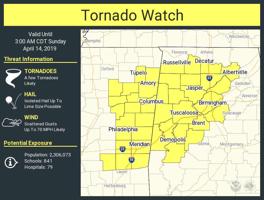
New tornado watch on the way....likely for parts of Central AL
Bama Ravens
Member
SilentShadow87
Member
Two children were killed in a car in Alto. Absolutely horrific.
Bama Ravens
Member
Interestingly, the STP on the HRRR keeps the highest values down along the coast.
Equus
Member
Tornado warning NW of Vicksburg on the second line. Lemme say, HRRR did wonderfully. Radar is almost identical to some of the CAM plots from last night, showing multiple lines with isolated rotating semi-discrete stuff embedded.
MattPetrulli
Member
Tornado issued for cell SW of Louisville, MS. Has a rather strong couplet.
Equus
Member
Now a small TDS with that
warneagle
Member
Spotter confirmed tornado near Carthage, MS
DaveFromGA
Member
- Admin
- #520
- Messages
- 3,618
- Reaction score
- 3,431
- Location
- Fayetteville, AR
- Special Affiliations
- SKYWARN® Volunteer
New TOR warning for Leake and Attala counties in MS.
Live feed from Watch Live https://www.wjtv.com/livestream
Live feed from Watch Live https://www.wjtv.com/livestream