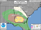
Day 1 Convective Outlook
NWS Storm Prediction Center Norman OK
0752 AM CDT Thu Apr 13 2023
Valid 131300Z - 141200Z
...THERE IS AN ENHANCED RISK OF SEVERE THUNDERSTORMS ACROSS PARTS OF
SOUTHERN GEORGIA AND EXTREME SOUTHEASTERN ALABAMA...
...SUMMARY...
A few tornadoes, along with damaging gusts and isolated large hail,
are possible today across parts of the Southeast. Isolated severe
gusts also are possible this afternoon over the central High Plains.
...Synopsis...
In mid/upper levels, pattern blockiness over the south-central/
southeastern CONUS will erode, as a synoptic-scale trough progresses
slowly but steadily across the Intermountain West and Great Basin.
Related height falls will spread eastward across the Rockies and
adjoining High Plains from MT to west TX. As that occurs, a 500-mb
cyclone -- centered initially over southern LA -- will accelerate
northeastward, reaching northern AL by the end of the period.
At the surface, 11Z analysis showed the low related to the LA
cyclone aloft, moving northward near the AL Coast. A warm front was
drawn from the low east-southeastward along the FL Panhandle Coast
past AAF, then across Apalachee Bay and the north-central FL
Peninsula. The surface low should move northwestward across
southwestern AL, occlude over southeastern MS, and unite with the
mid/upper cyclone center over central MS, around 00Z. By that time,
the warm front should reach central AL, south-central GA, and
northeastern FL, with a hybrid sea-breeze boundary and broader-scale
low-level convergence line southward down Atlantic coastal counties
of the peninsula. Overnight, the surface low should fill and take a
wobbly path across northern MS. The warm front should moves
northward to northern parts of AL/GA and central/southern SC, and
weakens somewhat.
Meanwhile, under the height falls, a lee trough will become better-
defined across the High Plains south of a low analyzed at 11Z near
LAR. A wavy front was drawn from the low across western NE, to
another weak low between HON-ATY, to southern MN and northern WI.
This front should remain quasistationary into this evening.
Overnight cyclogenesis over MN will lead to the boundary shifting
southeastward as a cold front over northeastern CO, central/
southwestern NE and southeastern SD by 12Z tomorrow.
...Southeast...
At least a couple bands of scattered thunderstorms are expected
today across the outlook area, with embedded supercells offering the
greatest tornado potential, along with sporadic hail. Damaging
nontornadic gusts are possible as well. For the near-term threat
across the central/eastern FL Panhandle and adjacent parts of
southeastern AL and southwestern GA, refer to SPC tornado watch 133
and related mesoscale discussions.
The greatest tornado potential will exist locally wherever a
sustained, mature supercell can interact with a narrow, northward-
shifting corridor in the warm-frontal zone featuring the overlap of:
1. Locally maximized low-level lift,
2. Relatively maximized boundary-layer vorticity,
3. Backed surface flow beneath the southern rim of an easterly to
southeasterly LLJ, leading to enlarged hodographs and 150-300 J/kg
effective SRH,
4. The northern fringe of a richly moist, surface-based,
warm-sector boundary later characterized by upper 60s to low 70s F
surface dewpoints, underlying
5. Steep midlevel lapse rates, especially in closer proximity to
the cold-core mid/upper low.
Diurnal heating, by contrast, may be stronger and longer-lasting
with eastward/southeastward extent from the low. The net result
should be a northwestward-narrowing corridor of warm-sector MLCAPE
extending just into the frontal zone, and ranging from about 1000-
1500 J/kg across most of FL and southern GA, to around 500-1000 J/kg
shifting northward over southern/central AL and extreme eastern MS,
east of the low. A relative concentration in both convective
coverage and CAPE/shear parameter-space overlap has become apparent
across parts of southeastern AL and south-central GA, supporting an
upgrade in tornado probabilities. Vertical shear farther south down
the convergence/sea-breeze zone in eastern FL will lead to messier,
more multicellular mode, but with isolated supercells still possible
(especially near localized boundary intersections). The overall
severe threat should diminish this evening and overnight as the
deep-layer cyclone penetrates further inland, the surface low and
lift each weaken, and the air mass relative to the warm-front
position stabilizes.
...Central High Plains...
Isolated to widely scattered thunderstorms are expected to develop
this afternoon near the lee trough, in a zone of overlap between
favorable diurnal heating (to near convective temperature) and
low-level convergence. Activity will form atop a marginally moist,
deep boundary layer, with steep low/middle-level lapse rates and
generally 40s F surface dewpoints. The main concern will be locally
strong-severe downdrafts accelerating through the well-mixed
subcloud layer. Diabatic, low-level stabilization should reduce the
convective/severe potential with time during early evening.
..Edwards/Smith.. 04/13/2023