
You know where. LOL! The usual. Oklahoma, Texas, Arkansas, Missouri, Louisiana, Mississippi, Alabama, and Tennessee. I had already figured we would have a threat next week because it's my birthday week.Where?
Navigation
Install the app
How to install the app on iOS
Follow along with the video below to see how to install our site as a web app on your home screen.
Note: This feature may not be available in some browsers.
More options
-
Welcome to TalkWeather! We see you lurking around TalkWeather! Take the extra step and join us today to view attachments, see less ads and maybe even join the discussion. CLICK TO JOIN TALKWEATHER
You are using an out of date browser. It may not display this or other websites correctly.
You should upgrade or use an alternative browser.
You should upgrade or use an alternative browser.
Severe Weather 2023
- Thread starter KevinH
- Start date
Huh, that next week potential threat could be the real deal. Climatology wise the deep south is in a sweet spot.
Wee bit in voodoo land, but looks pretty potent.
Wee bit in voodoo land, but looks pretty potent.
- Moderator
- #723
What part of next week?
Between the 26th and 29th.What part of next week?
- Thread starter
- #725
KevinH
Member
I just wanted to make sure. LolYou know where. LOL! The usual. Oklahoma, Texas, Arkansas, Missouri, Louisiana, Mississippi, Alabama, and Tennessee. I had already figured we would have a threat next week because it's my birthday week.
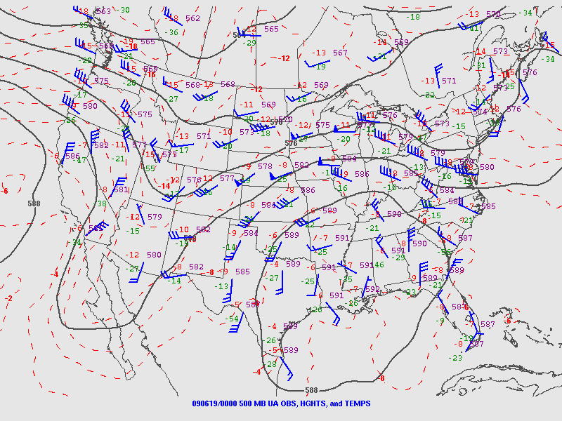
Since the “cap” is more applicable as the severe wx season shifts, this sounding absolutely
Blew my mind from DVN on June 18 2009 that I found from a post on storm track.
Supercell Composite of almost 60 and 7000 k/j of cape, but with meager shear. Want to know the result? Cap bust with one lone nocturnal supercell over Wisconsin lol.

Blew my mind from DVN on June 18 2009 that I found from a post on storm track.
Supercell Composite of almost 60 and 7000 k/j of cape, but with meager shear. Want to know the result? Cap bust with one lone nocturnal supercell over Wisconsin lol.
GFS 12z run has backed off on the threat for next week (26th-30th) and keeps everything localized in Texas.
Same thing with the 6z run. Still nothing on the horizon that screams “potent set up”, outside of the very conditional based set ups today and tomorrow.
It Does back up some of the year analogs Trey had. Highly active early months, a big outbreak in the Illinois, Indiana, Iowa, Missouri region, and a couple of plains set ups in May and June.
Last edited:
Tanner
Member
It's really hard to believe (as it just occurred to me) that we've already almost MATCHED the number of EF3+ tornadoes this year to last years, and it's only the second half of April.
- Moderator
- #729
The Wed-Thursday period of next week still holds potential for a significant severe risk in the Southeast.
- Thread starter
- #730
KevinH
Member
When you say SE, I hope you aren’t talking about AR, MO, OK.The Wed-Thursday period of next week still holds potential for a significant severe risk in the Southeast.
- Moderator
- #731
When you say SE, I hope you aren’t talking about AR, MO, OK.
I’m talking about southern and coastal regions of the Southeast.
- Thread starter
- #732
KevinH
Member
Ok… that’s me then lol DANGITI’m talking about southern and coastal regions of the Southeast.
CIPS/CSU for Wednesday
.jpg")

CIPS/CSU for Thursday:
.jpg")

atrainguy
Member
Neat video of a waterspout making landfall today in Florida.
Fairly easy to see why this cap Atmospheric Anti-Climax too. Lack of depth to the moist layer (and substantially lower MLCAPE than SBCAPE) as a result of a lack of lift and mixing. The cap did not lift or get mixed out. Difficult to get CI when there's still -111 J/kg MLCIN hanging around. Convective temperature there is 98 degrees, and 85 isn't even close to that.Since the “cap” is more applicable as the severe wx season shifts, this sounding absolutely
Blew my mind from DVN on June 18 2009 that I found from a post on storm track.
Supercell Composite of almost 60 and 7000 k/j of cape, but with meager shear. Want to know the result? Cap bust with one lone nocturnal supercell over Wisconsin lol.
View attachment 20008
Anticyclonic curvature aloft generally dominates the flow here, which is not conducive to large scale ascent that would lift/erode the cap.
Waiting to see if we want to post at https://talkweather.com/threads/severe-wx-threat-thu-4-27-23-ga-al.2134/, but here is the updated risk:What are overall thoughts for tomorrow and Wednesday? SPC saying a slight risk for here in TX both days
Attachments
- Thread starter
- #740
KevinH
Member
Added it to the threadWaiting to see if we want to post at https://talkweather.com/threads/severe-wx-threat-thu-4-27-23-ga-al.2134/, but here is the updated risk:
") Post away!
Post away!I initially created that thread bc of the CWASP 80% contours over AL/GA, but the SPC isn’t sold on it…… yet.