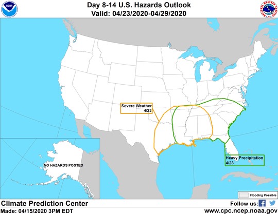
• Welcome to TalkWeather!
    We see you lurking around TalkWeather! Take the extra step and join us today to view attachments, see less ads and maybe even join the discussion.
    CLICK TO JOIN TALKWEATHER

This severe weather season will be?

  • Much Above Average

    Votes: 4 9.3%
  • Above Average

    Votes: 26 60.5%
  • Average

    Votes: 6 14.0%
  • Below Average

    Votes: 5 11.6%
  • Much Below Average

    Votes: 2 4.7%

  • Total voters
    43
  • Poll closed .
Status
Not open for further replies.

Kory

Member
Messages
4,928
Reaction score
2,119
Location
Tuscaloosa, Alabama
There is going to be multiple opportunities for severe wx over the next 2-3 weeks. Looks like the last hurrah so to say for severe weather for us in the Southeast.
 
Last edited:

Taylor Campbell

Moderator
Moderator
PerryW Project Supporter
Messages
2,113
Reaction score
2,216
Location
Wedowee, AL
Special Affiliations
  1. SKYWARN® Volunteer
The 12z run of the EURO and the recent trend towards it from the GFS (18z and 00z runs) sure do amplify the significance of the threat Sunday into Monday.
 

Kory

Member
Messages
4,928
Reaction score
2,119
Location
Tuscaloosa, Alabama
This is weekend isn't enough...we have another upcoming threat next week. Already highlighted by the CPC.

EVsYe2VXYAEiL6-
 
Last edited:

Taylor Campbell

Moderator
Moderator
PerryW Project Supporter
Messages
2,113
Reaction score
2,216
Location
Wedowee, AL
Special Affiliations
  1. SKYWARN® Volunteer
Models are showing a substantial severe weather event next Wednesday/Thursday.

Here is a loop of the most recent GFS ensembles for the period.

06Z-20200418_GEFSSE_con_scpens-96-156-150-300.gif
 

Bevo

Member
Messages
241
Reaction score
201
Location
Dallas, TX
That Ensemble 11 is gonna be a YIKES from me!
GFS has the storms rolling into TX much earlier in the day (between 1 AM - 1 PM Wednesday) but Euro has them beginning around 1 PM.
There's still some pretty big differences between the models with how much shear will be in place and with the timing though, seeing as we're still several days out. I'm sure once we get through the next couple of days and models begin to resolve more eyes will be on this one.
 

Kory

Member
Messages
4,928
Reaction score
2,119
Location
Tuscaloosa, Alabama
Smaller threat Wednesday night/Thursday morning, but quality moisture return just isn't there. We'll have to see beyond that as things look quieter than longer range stuff than it originally looked.
 

Bevo

Member
Messages
241
Reaction score
201
Location
Dallas, TX
New SPC Day 3 outlook outlines a hatched sig severe for a swath of north to central Texas.
Screen Shot 2020-04-20 at 9.11.10.png
...Discussion...
A positive-tilt shortwave trough will move from the southern Plains
eastward across the Gulf Coast states, with a broad area of
west/southwest 50-60 kt midlevel winds. At the surface, a weak area
of low pressure will move from OK during the day into AR, with a
front surging east across northern TX and the ArkLaTex. A dryline
will punch east across TX, except for Deep South TX where it will
become stationary.

East of the dryline, southerly winds will result in moisture
recovery over much of eastern TX during the day with mid to upper
60s F dewpoints common, then across LA and southern MS overnight.
The rapid advection of moisture into a relatively cool air mass over
the Southeast will result in widespread clouds, which will inhibit
heating except near the dryline (near I-35 in TX and OK).

The greatest threat of severe storms, including damaging hail, will
be near this dryline where storms will have access to stronger
heating. Despite a pronounced veer/back signal in the low-level wind
profile, strong deep-layer shear will support sustained cells,
perhaps a few supercells.

Numerous storms will persist overnight as they move into the lower
MS Valley, but the boundary layer, although moistening, will be
relatively cool. Thus, despite large SRH, it is unclear how much of
a tornado threat there will be. More likely, an MCS will produce
areas of wind damage.

Hatched area may be picking up on a damaging wind/hail risk as per NWS Fort Worth's thinking, though we will have to wait until tomorrow to see how the probabilities per hazard fall.
 

Equus

Member
Messages
3,295
Reaction score
3,380
Location
Jasper, AL
Special Affiliations
  1. SKYWARN® Volunteer
Models seem to have uptrended just a little for Thursday's threat, though only the NAM shows impressive thermos so certainly no guarantee yet. GFS and Euro both say tornado threat in whatever warm sector we manage to get; NAM is painting destruction and despair as expected though with funky wind profiles in some places. It's definitely a questionable outlier but insists on nearly 4,000 j/kg SBCAPE in east AL Thursday evening. GFS also starting to be onboard with increasing thermos over E AL/GA. We go from massive shear and no instability west of AL to increasingly impressive thermo but veered and weakening wind profiles to the east. Might be worth a thread though if we go Slight on the D3 tonight.
 

andyhb

Member
Messages
1,093
Reaction score
3,006
Location
Norman, OK
Big difference with that run of the NAM is that it slowed the trough considerably and allowed more time for the wave to amplify. Watch out if that becomes commonplace amongst guidance.
 

Equus

Member
Messages
3,295
Reaction score
3,380
Location
Jasper, AL
Special Affiliations
  1. SKYWARN® Volunteer
GFS is also very slightly onboard the slowing trend, but still wanna see guidance much more in agreement; needless to say the potential has risen a little. If no one else does I'll start a thread in the morning if we get thrown in a Slight
 
Last edited:
  • Like
Reactions: KoD

Taylor Campbell

Moderator
Moderator
PerryW Project Supporter
Messages
2,113
Reaction score
2,216
Location
Wedowee, AL
Special Affiliations
  1. SKYWARN® Volunteer
Big difference with that run of the NAM is that it slowed the trough considerably and allowed more time for the wave to amplify. Watch out if that becomes commonplace amongst guidance.

GFS ensembles trends are slowing it.
 
Status
Not open for further replies.
Back
Top