MikeP
Member
Maybe a different thread started for this one? Lets focus on tomorrow....Has anyone else noticed that winter weather system 2 weeks from now in the GFS that has snow &/or ice down to the Gulf Coast? Obviously thats a ways out but worth noting. To get ice & snow down to the coast means its probably got to get pretty cold. I hope this isnt a TX Feb 21 type event.
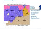
View attachment 11875
View attachment 11874
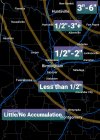
View attachment 11876