
Just a note that SPC's MCDs now have new graphics:
Navigation
Install the app
How to install the app on iOS
Follow along with the video below to see how to install our site as a web app on your home screen.
Note: This feature may not be available in some browsers.
More options
-
Welcome to TalkWeather! We see you lurking around TalkWeather! Take the extra step and join us today to view attachments, see less ads and maybe even join the discussion. CLICK TO JOIN TALKWEATHER
You are using an out of date browser. It may not display this or other websites correctly.
You should upgrade or use an alternative browser.
You should upgrade or use an alternative browser.
Severe WX March 23-25th, 2023
- Thread starter Lake Martin EF4
- Start date
Curious if the above average gulf temperatures will play into this event some. Haven't had a event that's been able to really play off the increased gulf temps off the coast.
Guess bham is expecting a upgrade lol
Guess bham is expecting a upgrade lol
They mentioned in their AFD this morning:
"Our public severe weather graphic will remain unchanged to remain
somewhat consistent with other national products, but an upgrade
may become necessary tomorrow night."
Also, the Maxwell radar (KMXX) is scheduled to go down for maintenance/upgrades starting tomorrow through next Thursday. I'm sure that means we'll get some severe weather down this way, lol.
Never fails. Although the silver lining is we've seen almost all busts with the corresponding maintenance schedule haha.They mentioned in their AFD this morning:
"Our public severe weather graphic will remain unchanged to remain
somewhat consistent with other national products, but an upgrade
may become necessary tomorrow night."
Also, the Maxwell radar (KMXX) is scheduled to go down for maintenance/upgrades starting tomorrow through next Thursday. I'm sure that means we'll get some severe weather down this way, lol.
ashtonlemleywx
Member

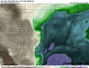
12z HRW FV3 shows a hella strong UH track across North Louisiana on Friday. Model run stops at 00z.
Last edited:
ashtonlemleywx
Member


12z NAM sfc cape Saturday morning/afternoon
Saturday could end up recycling into something interesting. These morning setups are the ones that have a higher ceiling imo.
Last edited:
Kragg
Member
Guess bham is expecting a upgrade lol
We’ve been pretty lucky the last few years with few late night/ early morning threats here in AL, but just because we’re due doesn’t mean I have to like it.
CheeselandSkies
Member
If the NAM is right, SPC's Enhanced/30 hatch is too far south. Greatest threat would be over northeast AR/MO bootheel wherever the warm front sets up. Not sure why it has such a sharp cutoff in EHI in far west TN/SW KY when the 60s dewpoints extend much further east.
Yeah the last real overnight outbreak threat I remember was April 28th 2014. (For my area) The last major tornado from a overnight event though with a non outbreak just a singular tornadic storm was January 2021 or it may have been 2022We’ve been pretty lucky the last few years with few late night/ early morning threats here in AL, but just because we’re due doesn’t mean I have to like it.
TH2002
Member
- Messages
- 4,973
- Reaction score
- 11,113
- Location
- California, United States
- Special Affiliations
- SKYWARN® Volunteer
Both SHV and DGX are mentioning the possibility of strong tornadoes in their respective forecast areas on Friday. And as for which town is in the virtual geographic center of the risk area, it’s none other…

Well that definitely catches my eye. Excerpt from BMX's AFD posted here earlier. A nighttime supercell threat would be a quite unsavory situation.
The low-amplitude nature of the 500 mb trough with broad cyclonic
curvature, and 200-300 mb diffluence overspreading the warm sector,
indicates that discrete supercells or line-embedded supercells
could be the primary storm mode. This has been explicitly
indicated by the ECMWF for several days.
It's likely several degrees too cold with temperatures in the open warm sector, for starters.Interesting that the first sniff of the 3K NAM out to 00Z Saturday is rather muted with the EHI as well as the simulated reflectivity/updraft helicity, but that seems to be somewhat common with that model. For some reason it doesn't really mirror the regular NAM to the extent you'd think it would, at least at the end of its range.
I wonder if it maybe has a later deepening of the surface low and hence the low level jet response and consequent enlarging of the hodographs takes place after the end of the run. Because the regular NAM looks extremely dangerous especially across northeastern Arkansas/the MO bootheel at 0Z Saturday. But, the hodographs are large and strongly curved across most of AR/LA.
- Admin
- #114
A tornado formed in Montebello, California, just east of Los Angeles. It is clear they do not see these very often.
CheeselandSkies
Member
Uh oh...18Z NAM suggests the favorable environment expanding a little more Friday evening, into more of western TN/southwestern KY. Where have we seen this in the not too distant past?...(not calling for a repeat of that-yet-but still, yikes).
Attachments
Uh oh...18Z NAM suggests the favorable environment expanding a little more Friday evening, into more of western TN/southwestern KY. Where have we seen this in the not too distant past?...(not calling for a repeat of that-yet-but still, yikes).

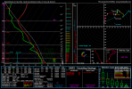
I mean, I challenge you to find a better sounding match than that. It's almost identical.
CheeselandSkies
Member
I mean, I challenge you to find a better sounding match than that. It's almost identical.
Not good.
A tornado formed in Montebello, California, just east of Los Angeles. It is clear they do not see these very often.
From what I have found in the tornado archive on NWS San Diego website, the last tornado that affected around Los Angeles in March was 1983.
Still remember the lead up to that event.Uh oh...18Z NAM suggests the favorable environment expanding a little more Friday evening, into more of western TN/southwestern KY. Where have we seen this in the not too distant past?...(not calling for a repeat of that-yet-but still, yikes).
And then the reaction to the thermals coming in and performing that afternoon