• Welcome to TalkWeather!
    We see you lurking around TalkWeather! Take the extra step and join us today to view attachments, see less ads and maybe even join the discussion.
    CLICK TO JOIN TALKWEATHER
Logo 468x120

Severe WX March 23-25th, 2023

Austin Dawg

Member
Sustaining Member
Messages
875
Reaction score
1,343
Location
Leander, Texas
Very pedestrian

Area Forecast Discussion
National Weather Service Austin/San Antonio TX
647 PM CDT Tue Mar 21 2023

.LONG TERM...
(Thursday through Tuesday)
Issued at 241 PM CDT Tue Mar 21 2023

An upper level short wave is forecast to push across south central
Texas from Thursday into Friday. The associated Pacific front is
expected to move across the area on Thursday evening into mid to
late Friday morning. A dry-line ahead of the Pacific front could
trigger isolated to scattered showers across the Rio Grande late
Thursday afternoon or early evening.

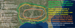
The Storm Prediction Center Day Three Severe Thunderstorm Outlook
highlights parts of the southern Edwards Plateau and Rio Grande
where storms are expected to quickly develop and become strong to
severe. The main weather hazards look to be large to very large hail
and damaging wind gusts.

The frontal boundary is forecast to exit the local area on Friday
afternoon. Dry and cooler conditions are expected across the local
area with highs in the mid 70s to mid 80s in the wake of the front
with breezy northwest to west winds 10 to 20 mph and up to 25 mph
across the Rio Grande and southern Edwards Plateau with gusts up to
35 mph.

At this time, chances for rain across south central Texas look good,
however, dry and breezy conditions bring elevated fire concerns for
areas along the Rio Grande and southern Edwards Plateau on Friday
afternoon. Good weather conditions are in store for Saturday with
sunny skies and highs in the 70s across the Hill Country and 80s
elsewhere.

Rain chances return on Sunday mainly for areas along and east of
Highway 281 as another front pushes across south central Texas.
Sunday`s highs are expected to reach the 80s most areas. In the wake
of the frontal passage, a dry and cooler airmass is expected to
spread across the area with Monday`s highs in the 70s over most
places with 80s along the Rio Grande. Isolated showers could not be
ruled out east of I-35 corridor in the afternoon.
 

UncleJuJu98

Member
100,000th Post
Messages
3,924
Reaction score
5,099
Location
Birmingham
That’s exactly why, at least in my case. I was actually thinking about this today, when was the last time we had a severe threat with good model agreement, decent parameters, and one that actually verified? We had the early January Dixie Surprise but was it the November 4th outbreak? Not really sure to be honest.

I can’t remember if there was something else that wasn’t very well forecasted on the Nov 4th outbreak, was it the instability?

Whether it be possibly wonky model Parameterization, the ingredients not lining up in the right way yet, or it’s just going to be one of those seasons is yet to be seen.
The long track tornado event is about the only memorable event so far, it was a doozy though, over verified with under forecasted paramters.

What really sucked the life out of me was the incredible setup of the super deep low pressure that turned out to be absolutely nothing.

I think with the event upcoming this Friday though the dry layer and extreme shear wont be present more so a typical southern event maybe a little low on instability but semi- similar to some of the 2021 march events but likely not as significant
 

andyhb

Member
Meteorologist
Messages
1,119
Reaction score
3,130
Location
Norman, OK
Synoptic setup on Friday screams trouble across LA and AR eastward to MS and AL. We'll see how the thermodynamics come into view later on, but with the mid/upper level jet punching right through the warm sector between 18z Friday and 06-09z Saturday, there should be no shortage of forcing to keep storms sustained.
 

UncleJuJu98

Member
100,000th Post
Messages
3,924
Reaction score
5,099
Location
Birmingham
If I had to guess I'd say maybe a march 17th 2021 analog is a decent one to look at,... Good synoptics less than stellar instability. Similar to this event unless a uptick in instability.

(Lol I'm having trouble figuring out the actual surface based instability on these soundings I thought it was actually around 700-1000 but it may be closer to 2000 or right below I'm not sure. I thought the March 17th event was the one with the lower instability out of the two march events.)

But let me clarify.., I doubt it'll be as significant unless model trends moving forward point that way. And the threat area would be a bit more higher west of Alabama I'd suspect.
 

ColdFront

Member
Messages
541
Reaction score
1,131
Location
Arctic
If I had to guess I'd say maybe a march 17th 2021 analog is a decent one to look at,... Good synoptics less than stellar instability. Similar to this event unless a uptick in instability.

(Lol I'm having trouble figuring out the actual surface based instability on these soundings I thought it was actually around 700-1000 but it may be closer to 2000 or right below I'm not sure. I thought the March 17th event was the one with the lower instability out of the two march events.)

But let me clarify.., I doubt it'll be as significant unless model trends moving forward point that way. And the threat area would be a bit more higher west of Alabama I'd suspect.
Yeah 2021 was… weird. We had those two high risks back to back in March but the main event being the December 10th outbreak and not from those two was different
 

UncleJuJu98

Member
100,000th Post
Messages
3,924
Reaction score
5,099
Location
Birmingham
Yeah 2021 was… weird. We had those two high risks back to back in March but the main event being the December 10th outbreak and not from those two was different
I generally use the two march 2021 events as a basis for forecasting tornado events for the deep south generally the track and similar synoptics that occur like those two events usually bring our more robust tornado days of course with the right accompanying ingredients.

For some reason the December 2021 event is kindve blotted on my mind I always forget that one. Kinda makes me question where was I in mid to late December to not pay attention to this event lol
 

ColdFront

Member
Messages
541
Reaction score
1,131
Location
Arctic
I generally use the two march 2021 events as a basis for forecasting tornado events for the deep south generally the track and similar synoptics that occur like those two events usually bring our more robust tornado days of course with the right accompanying ingredients.

For some reason the December 2021 event is kindve blotted on my mind I always forget that one. Kinda makes me question where was I in mid to late December to not pay attention to this event lol
Oh yeah I get what you’re saying! I just meant it was a weird “different” year in the that the main event was in December and not the two high risks days in March, which if you gave me no other context I’d always say “the March events were worse right?”
 

KevinH

Member
Messages
1,818
Reaction score
2,890
Location
West Central GA
That’s exactly why, at least in my case. I was actually thinking about this today, when was the last time we had a severe threat with good model agreement, decent parameters, and one that actually verified? We had the early January Dixie Surprise but was it the November 4th outbreak? Not really sure to be honest.

I can’t remember if there was something else that wasn’t very well forecasted on the Nov 4th outbreak, was it the instability?

Whether it be possibly wonky model Parameterization, the ingredients not lining up in the right way yet, or it’s just going to be one of those seasons is yet to be seen.
And this is why I have decided not to really start paying attention until D3 lol
 

Timhsv

Member
Messages
450
Reaction score
786
Location
Meridianville, AL.
Special Affiliations
  1. SKYWARN® Volunteer
Synoptic setup on Friday screams trouble across LA and AR eastward to MS and AL. We'll see how the thermodynamics come into view later on, but with the mid/upper level jet punching right through the warm sector between 18z Friday and 06-09z Saturday, there should be no shortage of forcing to keep storms sustained.
Andy always gets my attention..
 

JBishopwx

Member
Sustaining Member
Messages
913
Reaction score
2,042
Location
Ackerman, MS
Special Affiliations
  1. SKYWARN® Volunteer
 Thursday:
SPC1.jpg

.THERE IS A SLIGHT RISK OF SEVERE THUNDERSTORMS FROM
CENTRAL/EASTERN OKLAHOMA INTO THE TEXAS HILL COUNTRY...

...SUMMARY...
Thunderstorms capable of hail, some very large, and damaging gusts
are possible Thursday afternoon through Friday morning across the
southern Plains.

...Synopsis...
Presence of western CONUS troughing and subtropical ridging over the
Gulf of Mexico will contribute to a belt of enhanced southwesterly
flow extending from northern Mexico northeastward across the central
Plains and Mid MS Valley early Thursday. A pair of shortwave troughs
will be embedded within this belt of stronger flow, one initially
near the Mid MO Valley and the other across southern AZ/northern
Mexico. Both shortwaves are expected to progress northeastward, with
the second shortwave moving through the southern High Plains during
the afternoon/evening, reaching KS/OK by early Friday morning.

The surface pattern Thursday morning will likely feature a low near
the northern IL/IN border vicinity, with a cold front extending
southwestward to another low over northwest TX. This front is
expected to move eastward/southeastward across the OH Valley, while
the southern portion moves more southeastward/southward across the
Ozark Plateau and much of OK. Guidance varies on the position of the
front over OK. Secondary surface cyclogenesis is anticipated over
the TX Low Rolling Plains Thursday afternoon, with the resulting low
then moving eastward into north TX.

...OH Valley Thursday morning...
Elevated thunderstorms will likely be ongoing near the surface low
across northern IL/northern IN early Thursday morning. Strong
vertical shear and steep mid-level lapse rates will be in place,
supporting the potential for a few strong updrafts capable of hail.
These early morning storms are expected to continue eastward, likely
outrunning most of the buoyancy as they move into OH during the late
morning.

...Southern Plains Thursday afternoon through Friday morning...
Low 60s dewpoints are expected be in place along the front
early Thursday morning, likely increasing into the mid 60s by the
late afternoon. Recent guidance has trended slower with the front,
keeping more of central and eastern OK ahead of the front during the
afternoon. Increasing low-level moisture coupled with modest daytime
heating should destabilize the airmass south of the
front by the late afternoon. This instability coupled with
convergence along the front is expected to result in thunderstorm
development, likely beginning over central OK. Vertical shear will
be strong, and the initial more cellular development may produce
large hail. Front-parallel deep shear should result in any
near-front development tracking northward over the front quickly,
likely limiting the surface-based warm sector development. Even so,
a brief temporal window for may exist for damaging gusts and/or a
tornado.

Thunderstorm development is also anticipated farther south, ahead of
the deepening surface low expected to move into northwest TX during
the early evening. A more cross-boundary vertical shear
vector is anticipated here, which could support a greater potential
for storms to stay surface-based. However, the presence of low-level
stability suggest an elevated storm mode, with the cold front acting
as the initiation mechanism. Like the storms farther north, hail is
the main severe threat, with some very large hail possible. As the
low and associated front continue eastward, storm coverage should
increase southward across the TX Hill Country/Edwards Plateau. Hail
and damaging gusts are possible with this line of storms as it moves
eastward toward central TX early Friday morning.
 

JBishopwx

Member
Sustaining Member
Messages
913
Reaction score
2,042
Location
Ackerman, MS
Special Affiliations
  1. SKYWARN® Volunteer
Friday:

SPC3.jpg

.SUMMARY...
Supercell thunderstorms capable of all severe hazards, including
strong tornadoes, are possible across the Lower Mississippi Valley
on Friday.

...Synopsis...
The upper pattern early Friday morning will likely be characterized
by broad troughing across the western CONUS and subtropical ridging
centered over the Straits of Florida. Enhanced mid-level flow will
extend throughout western and southern periphery of the upper trough
and then throughout the northwestern periphery of the subtropical
ridge. A low-amplitude shortwave trough is forecast to move from the
base of the upper trough quickly eastward across the southern Plains
throughout the day, and then more northeastward across the Mid-South
overnight. Strong mid-level flow (i.e. 100 kt at 500-mb) will
accompany this shortwave, spreading across TX into the Mid-South.

The surface pattern preceding this shortwave trough is expected to
feature a low over north TX early Friday, with a cold front
extending southward from this low into the TX Hill Country and a
stationary front extending northeastward into the Middle OH Valley.
This low is forecast to move northeastward throughout the day, while
deepening significantly.

...Lower MS Valley...
Expectation is for a broad area of upper 60s dewpoints to be in
place from east TX across the Lower MS Valley, ahead of the surface
low and associated front. Cloud cover may temper daytime heating,
but afternoon temperatures will likely still reach the 80s,
contributing to moderate buoyancy across much of the region. In
addition to this buoyancy, moderate mid-level flow atop
strengthening low-level flow (supported by the maturing cyclone
ahead of the approaching shortwave trough) will contribute to long
hodographs with substantial low-level magnitude and veering. As a
result, the environment will be very favorable for supercells.

Current expectation is for storms to develop during the afternoon
over southwest AR and western LA (perhaps as far west as east TX).
This development should occur ahead of the cold front within the
open warm sector, maturing as it moves eastward across the Lower MS
Valley. A discrete supercell mode is anticipated initially, with all
severe hazards possible, including strong tornadoes. Upscale growth
into a convective line is anticipated after this initially discrete
mode, with the line pushing eastward across MS and AL overnight.

...Mid MS Valley...
Despite less buoyancy that areas farther south, augmented forcing
for ascent close to the surface low could result in bowing line
segments capable of damaging wind gusts and embedded tornadoes
Friday afternoon through Friday evening.
 

JBishopwx

Member
Sustaining Member
Messages
913
Reaction score
2,042
Location
Ackerman, MS
Special Affiliations
  1. SKYWARN® Volunteer

UncleJuJu98

Member
100,000th Post
Messages
3,924
Reaction score
5,099
Location
Birmingham
Decent sized enchaned for the delta. NAM has really been pushing the discreet convection ahead of the main line
 

UncleJuJu98

Member
100,000th Post
Messages
3,924
Reaction score
5,099
Location
Birmingham
Im actually starting to become impressed Nam is consistent with showing a base 1000j of cape now even into the overnight hours.witg cyclogenesis occuring as it nears into west Tennessee maintaining the instability may be possible overnight.

This event doesn't have the pesky dry layer/warm layer or extreme shear like last event so those two fail modes seem to be off the table.

Seems like we are gearing towards more of a overnight threat once it gets into the delta posisblity and moves east.
 
Last edited:
Messages
2,854
Reaction score
4,642
Location
Madison, WI
It would be fitting if this was the setup that produced something higher end (like 1/12, or perhaps even beyond that) given the model inconsistency that has plagued it from longer range. Seems like we've had numerous setups already this year that had much better consistency and agreement from further out, only for them to still fall apart or at least diminish considerably in ceiling inside of Day 4.
 

TileDude

Member
Messages
84
Reaction score
112
Location
Morris, AL
From Birmingham NWS morning discussion:

From a synoptic perspective, there are several bullish factors
pointing toward a potentially significant severe weather event
across the MS/AL region. In fact, the shape of the 500mb trough on
the global models is classic and suggestive of a tornado outbreak
across the Deep South. Of course there are other ingredients that
need to fall into place for that potential to be realized, but we
are seeing trends in that direction. Moisture quality and
instability has improved when looking at the trend of 850-925 mb
dewpoints, but models are very likely not handling the lowest part
of the boundary layer correctly during the overnight hours.
Temperatures on Friday will reach the 80s across the region, and
there is no good reason why temperatures should fall into the mid
to upper 60s during the evening in the midst of southerly winds
and an increasing low-level jet, as shown by some models.
Correcting for this bias suggests that temperatures will be in the
70-73F range as dewpoints increase into the mid to upper 60s.
This should yield more instability than currently depicted by the
GFS and ECMWF. Additionally, cold advection at 500mb is being
indicated, and the leading edge of this appears to be paired with
the expected corridor of severe storms. This should help maintain
or enhance mid-level lapse rates through the event, while
tempering the effects of latent heat release and not allowing the
atmosphere to turn over.
 
Messages
2,854
Reaction score
4,642
Location
Madison, WI
This is a very unscientific observation but it's one I've made over many years of amateur armchair forecasting. On the forecast soundings for Friday cherry-picked from the areas of highest EHI, I'm consistently seeing at least one, often more "sig" analogs in the SARS list (Birmingham at 18Z 12/16/00 - 2000 Tuscaloosa F4 - seems to be a common one).

A lot of times I've seen events where the forecast soundings in the days leading up to it have impressive numbers for the parameters and may even trip the "PDS TOR" tag, but if they don't have any analog matches or only "weak" ones, it's a red flag that there's something subtly "off" about the environment and the event is likely to bust or underperform.
 
Messages
1,072
Reaction score
1,317
Location
jackson tennessee
Special Affiliations
  1. SKYWARN® Volunteer
It would be fitting if this was the setup that produced something higher end (like 1/12, or perhaps even beyond that) given the model inconsistency that has plagued it from longer range. Seems like we've had numerous setups already this year that had much better consistency and agreement from further out, only for them to still fall apart or at least diminish considerably in ceiling inside of Day 4.
Why I’m little hesitant still be honest… I sit on the sidelines little longer , perhaps until 0z model runs tonight. Then I start chime in
 
Back
Top