
Trey got anything out for this outlined time period? I actually deleted Twitter hahaha
Navigation
Install the app
How to install the app on iOS
Follow along with the video below to see how to install our site as a web app on your home screen.
Note: This feature may not be available in some browsers.
More options
-
Welcome to TalkWeather! We see you lurking around TalkWeather! Take the extra step and join us today to view attachments, see less ads and maybe even join the discussion. CLICK TO JOIN TALKWEATHER
You are using an out of date browser. It may not display this or other websites correctly.
You should upgrade or use an alternative browser.
You should upgrade or use an alternative browser.
Severe WX March 23-25th, 2023
- Thread starter Lake Martin EF4
- Start date
F
Former Member
Guest
Change the thread title then, Chief.Can we please keep discussion of any potential threat after the 24th in the Severe Weather 2023 thread. Thank you. This thread is for the system on the 23rd-24th.
I mean I would get it if the two events were separated by 4-5 days. But where the two are so close together it’s just going to create multiple conversation streams in two different threads.
So besides the new rules, is it also system
Specific now like you indicated?
I recall some of the best threads in here covering long periods of time where there was severe weather on multiple days in a timespan (May 2019 megathread comes to mind).
So besides the new rules, is it also system
Specific now like you indicated?
I recall some of the best threads in here covering long periods of time where there was severe weather on multiple days in a timespan (May 2019 megathread comes to mind).
Last edited:
I Don’t think so, not yet.Trey got anything out for this outlined time period? I actually deleted Twitter hahaha
Austin Dawg
Member
We probably should just start titling them "The Next Severe Event(s)" {dates to be decided upon by Mother Nature... soon, we hope}
TH2002
Member
- Messages
- 4,973
- Reaction score
- 11,113
- Location
- California, United States
- Special Affiliations
- SKYWARN® Volunteer
I actually deleted Twitter hahaha

- Thread starter
- #28
Lake Martin EF4
Member
Agreed. Someone else in this thread suggested extending it to the 26th. I did just that.I mean I would get it if the two events were separated by 4-5 days. But where the two are so close together it’s just going to create multiple conversation streams in two different threads.
So besides the new rules, is it also system
Specific now like you indicated?
I recall some of the best threads in here covering long periods of time where there was severe weather on multiple days in a timespan (May 2019 megathread comes to mind).
- Admin
- #29
- Messages
- 3,618
- Reaction score
- 3,431
- Location
- Fayetteville, AR
- Special Affiliations
- SKYWARN® Volunteer
Perfect. Thanks. I don't see a need to separate something that will be hours apart.Agreed. Someone else in this thread suggested extending it to the 26th. I did just that.
DISCUSSION...
Upper pattern early D4/Thursday is forecast to consist of a western
CONUS trough and subtropical ridging centered over the Gulf of
Mexico. Enhanced mid-level westerly/southwesterly flow will persist
between these two features, extending from northern Mexico into the
Great Lakes region. The surface pattern is expected to feature a low
over northern IN, with a cold front extending southwestward across
the Mid MS Valley, Ozark Plateau, and OK into southwest TX.
Thunderstorm development is anticipated along this front D4/Thursday
afternoon, supported by ample pre-frontal moisture and a combination
of large-scale forcing for ascent attendant to a shortwave moving
into the southern High Plains and convergence along the front. Given
the expected vertical shear, supercells are possible in areas where
a discrete mode can be maintained. This appears most probable from
south-central OK into the TX Hill Country.
A shortwave trough will likely continue eastward across the southern
and central Plains on D5/Friday. An associated surface low is
expected to develop along the front over AR before then continuing
northeastward ahead of the shortwave. Thunderstorms will likely
already be ongoing along the front, and the severity of these storms
will be linked to the amount of downstream destabilization.
Reintensification appears most probable across central and southern
MS, where some potential for discrete storms ahead of the front also
exists.
Variability within the guidance limits forecast confidence from
D6/Saturday through D8/Monday. The late-week shortwave trough will
likely continue eastward through the Mid-Atlantic and coastal
Southeast on D6/Saturday, but severe potential is uncertain given
questions about frontal timing and low-level moisture. Moisture
return appears possible across the southern Plains and Lower MS
Valley on D7/Sunday into D8/Monday, ahead of a low-amplitude
shortwave trough. But aforementioned variability limits
predictability.
.jpg")

Hey now .png")
Me to the 00z EURO 
- Moderator
- #33
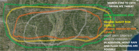
Point soundings off the GFS where the worst of this threat lines up (which looks from far east TX, through LA into southwest MS) shows SBCAPE over 2000j/kg and 0-1km SRH over 250m2/s2+(higher effective inflow). SARS shows several (3-4) analog matches tagged significant.
Timhsv
Member

One of the more impressive consensus on a larger scale severe impact I've seen from cips.

Austin Dawg
Member

Large area = possible larger event. We're moving into mid-spring and warmer temps.
Very impressiveCSU-MLP probs for D5. Broad area of 15%+.
View attachment 18826
I'm more so impressed by that large consensus on the 5 reports in the Mississippi Alabama region from the top 15 events. Usually you won't have such high consensus on the 5 reports one.
Large area = possible larger event. We're moving into mid-spring and warmer temps.
Maybe the high consensus is do to the similarity to your typical severe event in the south with a sub 1000mb low with a adequate warm sector ??
Last edited:
Wow! The 12z GFS has a 994 mb over Memphis!! Will the inst instability be there though if the wind shear is? Hm, yet to be seen 