
Definitely weird seeing that at this stage in the game. I’m trying to think of the last forecasted severe outbreak where we weren’t guessing all the way up until the last minute and had good model consistency and agreement a few days before.So far not really seeing anything particularly impressive simulated convection/UH-wise, despite the forecast environment, on anything but the HRW-FV3 (otherwise known as the "supercell printer" - even more so than the HRRR), but it's still early.
Navigation
Install the app
How to install the app on iOS
Follow along with the video below to see how to install our site as a web app on your home screen.
Note: This feature may not be available in some browsers.
More options
-
Welcome to TalkWeather! We see you lurking around TalkWeather! Take the extra step and join us today to view attachments, see less ads and maybe even join the discussion. CLICK TO JOIN TALKWEATHER
You are using an out of date browser. It may not display this or other websites correctly.
You should upgrade or use an alternative browser.
You should upgrade or use an alternative browser.
Severe WX March 23-25th, 2023
- Thread starter Lake Martin EF4
- Start date
- Moderator
- #143
If I were to draw an outlook map mine would be much like the current Day 3 Storm Prediction Center outlook with most of my confidence geared towards the southern half of the current enhanced risk (Louisiana into Southwest MS).
Last edited:
Timhsv
Member

Interesting to say the least


THERE IS A MODERATE RISK OF SEVERE THUNDERSTORMS ACROSS NORTHEAST
LOUISIANA...SOUTHEAST ARKANSAS...AND WESTERN MISSISSIPPI...
...SUMMARY...
Supercell thunderstorms capable of all severe hazards, including
strong tornadoes, are possible across the Lower Mississippi Valley
on Friday.
...Synopsis...
Upper troughing is expected to be in place over the western CONUS
early Friday morning. Strong mid-level flow will extend throughout
the periphery of this trough into the more confluent flow north of
the subtropical ridging across the eastern CONUS. A shortwave trough
is forecast to move through this enhanced mid-level flow, tracking
quickly eastward across the southern Plains during the day, and more
northeastward into the Mid MS Valley overnight. Mid-level flow is
expected to strengthen as the shortwave moves eastward, with 100+ kt
at 500 mb spreading across TX into the Mid-South.
At the surface, a low initially over north TX is forecast to move
northeastward ahead of the approaching shortwave, moving into
northern AR by Friday evening and through the Lower OH Valley
overnight. This low is expected to deepen throughout the day, and
this cyclogenesis will result in a broad area of moderate southerly
flow across the Lower MS Valley/Mid-South into the Southeast and TN
Valley. Environmental conditions appear favorable for numerous
severe thunderstorms from the Lower MS Valley through the Mid-South
and into the Mid MS and Lower OH Valleys.
...Lower MS Valley into the Southeast...
A broad warm sector, characterized by dewpoints in the upper 60s, is
forecast to be in place from east TX across much of the Lower MS
Valley and Mid-South early Friday morning. Thunderstorms may be
ongoing early Friday morning along a cold front moving eastward
across east TX. This cold front is expected to make gradual eastward
progress, as its parent surface low deepens while moving from
eastern OK into AR. This overall evolution will contribute to a
continued mass response across the warm sector, with low-level
moisture increasing throughout the day amid strengthen southerly
flow. This increase in low-level moisture coupled with modest
heating is expected to result in airmass destabilization during the
late afternoon. This destabilization coupled with large-scale ascent
attendant to the approaching shortwave (perhaps augmented by
low-level confluence) will likely result in discrete thunderstorm
development within the warm sector ahead of the front.
Current thinking is that this initial development is most likely to
occur in the TX/LA border vicinity. The downstream air mass will be
moderately buoyant, with guidance suggesting MLCAPE around 1000-1500
J/kg and max 2-6 km AGL lapse rates around 8 deg C per km. Robust
vertical shear is also expected, with a strong low-level jet (i.e.
50-60 kt at 850 mb) developing during the evening beneath
strengthening mid-level flow. Forecast hodographs depict
substantial low-level speeds and veering, with 0-1 km storm-relative
helicity from 200 to 300 m2/s2. A discrete supercell mode is
anticipated initially, with all severe hazards possible, including
strong tornadoes. With storms expected to develop in the LA/TX
border vicinity, discrete storm maturation is anticipated across
northeast LA, southeast AR, and western MS.
Upscale growth into a convective line is anticipated after this
initially discrete mode, with the line pushing eastward across MS
and AL overnight. Robust kinematic fields are expected to persist,
support a continued threat for strong gusts and line-embedded
tornadoes.
...Mid-South into the TN and Lower OH Valleys...
A more convoluted convective evolution is anticipated from
central/northern AR northeastward into the Lower OH Valley on
Friday. Storms will likely be ongoing along and north of stationary
boundary extending from east-central OK northeastward into northern
KY. A low-probability threat for hail is expected throughout the
morning and into the early afternoon as warm-air advection promotes
continued thunderstorm development along this boundary.
A gradual increase in storm intensity is then expected during the
afternoon as the surface low begins to deepen across AR and
large-scale forcing for ascent attendant to the shortwave increases.
Buoyancy will be more modest than areas farther south, but the
strong ascent and increasing shear is still expected to support
intense updrafts. Given the presence of the stationary front and
stronger forcing, a linear mode is anticipated, with this line then
progressing quickly east-northeastward across the Mid-South during
the evening and into more of the Lower OH and TN Valleys overnight.
Strong wind gusts will be primary hazard within this line, but
line-embedded tornadoes will be possible as well.
Last edited:
Equus
Member
I strongly get the feeling BMX really wants to see the enhanced pulled further east, feels like that will happen by the D1
Sawmaster
Member
Uhhh....
Confirmed now. EF1 with a 0.42 mile path, 50 yds wide. Also one in Carpenteria.
Brice
Member
i really hope people that aren’t in the highest threat will take this seriously, just because you’re not in the MDT risk doesn’t mean you won’t see action, 2 years ago with mayfield is a perfect example, caught a lot of people off guard, therefore a lot of deaths took place. Based on what everyone has said this looks like the most favorable event to drop something big and actually do it since the early November outbreak in Texas last year.
ashtonlemleywx
Member
The Delta also happens to be in a radar hole. Makes it even more dangerous at night.
Updated graphic by the bham NWS.
Looks to be a purely in the dark event
Looks to be a purely in the dark event
kcyalater
Member
i think there’s a lot of question on whether the dynamics will be there to support anything southeast of jasper ish.I strongly get the feeling BMX really wants to see the enhanced pulled further east, feels like that will happen by the D1
Last edited:
Scott81
Member
I would not be surprised If that enhanced risk gets pushed further east.
- Admin
- #154
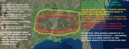
I am curious as to why your moderate is so wide and includes areas SPC either puts only at a marginal risk or even bordering the area that is at most a thunderstorm on the SPC map? What dynamics are you using or seeing that would lead you to believe that the moderate risk level would cover this much area? I am thoroughly confused by it.My updated severe wx graphic.
I think we are gearing up for a relatively high risk Mississippi threat, with potentially a violent or long track tornado or two, if we continue to proceed on current thinking. A high risk seems plausible (mainly for missippi) if model trends continue to support more isolated and also higher instability/moisture.
I think this could be a big missippi tornado threat. A lesser threat east of the Mississippi border but maybe still robust.
I think this could be a big missippi tornado threat. A lesser threat east of the Mississippi border but maybe still robust.

I mean, I challenge you to find a better sounding match than that. It's almost identical.
The image isn't showing up for me, and the URL is giving a "Not found" response. What sounding was in the image?
tennessee storm chaser
Member
- Messages
- 1,876
- Reaction score
- 4,283
- Location
- jackson tennessee
- Special Affiliations
- SKYWARN® Volunteer
Wouldn’t suprise me see moderate area expand some more northI would not be surprised If that enhanced risk gets pushed further east.
ashtonlemleywx
Member
So far not really seeing anything particularly impressive simulated convection/UH-wise, despite the forecast environment, on anything but the HRW-FV3 (otherwise known as the "supercell printer" - even more so than the HRRR), but it's still early.

06z HRRR did produce a long track UH from Tallulah, LA to Tupelo, MS.
12z HRRR is currently running. Interested to see if it maintains similar track.
Those updrafts swaths are utterly amazing.
06z HRRR did produce a long track UH from Tallulah, LA to Tupelo, MS.
12z HRRR is currently running. Interested to see if it maintains similar track.
Many long track supercells with potential accompany tornado families.
The end of the 00z HRW-WRF Run looks to be pretty concerning as well. This is the best model for this range IMO. 12z coming shortly for it as well..
HRW-WRF has the low pressure clocking in at a whopping 994mb.. geez @ashtonlemleywx
HRW-WRF has the low pressure clocking in at a whopping 994mb.. geez @ashtonlemleywx