• Welcome to TalkWeather!
    We see you lurking around TalkWeather! Take the extra step and join us today to view attachments, see less ads and maybe even join the discussion.
    CLICK TO JOIN TALKWEATHER

Severe WX March 23-25th, 2023

cincywx

Member
Messages
441
Reaction score
797
Location
Cincinnati, OH
Special Affiliations
  1. SKYWARN® Volunteer
uh03_max.us_se.png


06z HRRR did produce a long track UH from Tallulah, LA to Tupelo, MS.

12z HRRR is currently running. Interested to see if it maintains similar track.

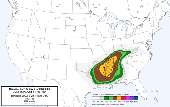
very interested in how, if nothing else, several models [experimental and operational] seem to agree on a narrow corridor of heightened tornado potential in north-central mississippi.
 
Last edited:

UK_EF4

Member
Messages
566
Reaction score
1,301
Location
NW London
I think if current trends are maintained, a high risk is relatively likely - moreso than any other threat this year with now a relatively strong and consistent signal for discrete & semi discrete convection in a very favourable environment for strong tornadoes. Some of the CAMS are starting to get that ‘look’ on simulated reflectivity as well - though that is not a proper Method of forecasting! Trends are looking concerning as well. We will see I guess…
 

UncleJuJu98

Member
100,000th Post
Messages
3,913
Reaction score
5,076
Location
Birmingham
Lol the 12z hrrr chose violence lol.

It does favor more of a bowing segment it seems for north Mississippi and north Alabama though. Not sure if this is cause of the hrrr wonky range. Let's see what the 12z WRF Says in a bit.
 

Taylor Campbell

Moderator
Moderator
PerryW Project Supporter
Messages
2,109
Reaction score
2,203
Location
Wedowee, AL
Special Affiliations
  1. SKYWARN® Volunteer
The 12z HRRR run showed consistency to the 06z run with the long track (discrete) mesocyclone at start of 22z (5pm central) near Fort Polk South in southwest Louisiana to I-20 near Monroe, LA by 01z (8pm central). This same mesocyclone continues into the northwest delta region into MS before the line catches up with it around 03-04z. I suspect this storm will be favorable of several significant tornado instances and is squared down the middle of the current moderate risk.
 
Last edited:

warneagle

Member
Messages
3,787
Reaction score
3,378
Location
Arlington, VA
Special Affiliations
  1. SKYWARN® Volunteer
The 12z HRRR run showed consistency to the 06z run with the long track (discrete) mesocyclone at start of 22z (5pm central) near Fort Polk South in southwest Louisiana to I-20 near Monroe, LA by 01z (8pm central). This same mesocyclone continues into northwest delta region into MS before the line catches up with it around 03-04z. I suspect this storm will be favorable of several significant tornado instances.
Yeah the HRRR and FV3 seem to be picking up on a couple of long-tracked supercells moving along that Shreveport-Tupelo axis, roughly, in the 22z-04z timeframe. There's enough consistency there that the SPC might want to consider expanding the MDT a bit further north and east, imo.

Meanwhile the 3km NAM is basically a non-event, which makes no sense to me.
 

UncleJuJu98

Member
100,000th Post
Messages
3,913
Reaction score
5,076
Location
Birmingham
Yeah the HRRR and FV3 seem to be picking up on a couple of long-tracked supercells moving along that Shreveport-Tupelo axis, roughly, in the 22z-04z timeframe. There's enough consistency there that the SPC might want to consider expanding the MDT a bit further north and east, imo.

Meanwhile the 3km NAM is basically a non-event, which makes no sense to me.
Makes total sense lol.
3km nam is abysmal haha
 
Messages
1,053
Reaction score
1,268
Location
jackson tennessee
Special Affiliations
  1. SKYWARN® Volunteer
Yeah the HRRR and FV3 seem to be picking up on a couple of long-tracked supercells moving along that Shreveport-Tupelo axis, roughly, in the 22z-04z timeframe. There's enough consistency there that the SPC might want to consider expanding the MDT a bit further north and east, imo.

Meanwhile the 3km NAM is basically a non-event, which makes no sense to me.
Easily see the moderate risk expand into sw Tennessee and very northern miss. Next update
 

TheSuckZone

Member
Messages
269
Reaction score
560
Location
Kansas
I think we are gearing up for a relatively high risk Mississippi threat, with potentially a violent or long track tornado or two, if we continue to proceed on current thinking. A high risk seems plausible (mainly for missippi) if model trends continue to support more isolated and also higher instability/moisture.

I think this could be a big missippi tornado threat. A lesser threat east of the Mississippi border but maybe still robust.

Are upgrades to the outlooks ever issued due to storms being overnight as opposed to daytime? Or is that something that is not taken into consideration?
 

warneagle

Member
Messages
3,787
Reaction score
3,378
Location
Arlington, VA
Special Affiliations
  1. SKYWARN® Volunteer
Are upgrades to the outlooks ever issued due to storms being overnight as opposed to daytime? Or is that something that is not taken into consideration?
The outlooks cover the entire 24-hour period they're valid for, so if anything during that period merits an upgrade in the risk category, they'll upgrade it.
 

UncleJuJu98

Member
100,000th Post
Messages
3,913
Reaction score
5,076
Location
Birmingham
I'm hesitant on taking some of these super linear long range hrrr runs and a bit of the WRF. Hrrr is known to be wonky in the long range. Just take into account what the 00z hi res euro shows.

Although the 12Z HRRR. Is relatively close to what I think may occur intially
 

ColdFront

Member
Messages
541
Reaction score
1,131
Location
Arctic
Here is one of the arbitrary PDS TOR soundings (northwestern LA 21z)
View attachment 18899
That 12-16-2000 BMX analog has been a mainstay throughout most of these soundings.

I can’t remember who brought it up earlier in the thread but they made an excellent point on looking to see if there are any “sig” analogs to get the feel of a forecasted event, while unscientific, can help discern out some of the model noise.

Are there any plans for special soundings today?
 

Taylor Campbell

Moderator
Moderator
PerryW Project Supporter
Messages
2,109
Reaction score
2,203
Location
Wedowee, AL
Special Affiliations
  1. SKYWARN® Volunteer
The models looks like the strongest signal for a significant tornado event since the Jan 12th and Nov 4th events. The EURO appears to be roughly 50 miles further south with greatest threat which would put that long track discrete supercell more on track from Alexandria, LA to Natchez, MS.
 

ColdFront

Member
Messages
541
Reaction score
1,131
Location
Arctic
How likely is it that the failure modes win out again? That seems to be a theme for 2023…
I mean failure modes are always looming in weather lol especially mesoscale wise. There was a minority(small, but not insignificant amount) of folks on another severe wx board that were insistent the entire week building up to 4/27 that either the convection in the morning would sap the atmosphere, or another mode I can’t think of at this time. Fred was insistent throughout that the “crapvection” wouldn’t harm the later threat.

And disclaimer, I’m not comparing this to 4/27 at all, I’m just saying even the gold standard of set ups will have some failure modes leading up to the event.
 

Tanner

Member
Messages
260
Reaction score
454
Location
Granville, MA
How likely is it that the failure modes win out again? That seems to be a theme for 2023…
I think the biggest question for me going into this event is the LLLR, as have been the last several big setups. Models such as the RAP and the NAM are not showing impressive low level lapse rates, which is sufficient in storm development and sustainability. Right now, as it stands, I think the mesoscale features such as surface heating will be the determining factor in how tomorrow plays out.

Sigh...I hate having so much uncertainty the day before a weather event.
 
Back
Top