
Navigation
Install the app
How to install the app on iOS
Follow along with the video below to see how to install our site as a web app on your home screen.
Note: This feature may not be available in some browsers.
More options
-
Welcome to TalkWeather! We see you lurking around TalkWeather! Take the extra step and join us today to view attachments, see less ads and maybe even join the discussion. CLICK TO JOIN TALKWEATHER
You are using an out of date browser. It may not display this or other websites correctly.
You should upgrade or use an alternative browser.
You should upgrade or use an alternative browser.
Hurricane Hurricane IDALIA: threat to the northeastern Gulf Coast
- Thread starter Casuarina Head
- Start date
I wouldn't rule out what the GFS is showing with Idalia or the remnants of looping back around and coming back west. The only and last more recent storm to do that was Ivan in 2004.
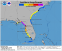
NHC now forecasts a peak intensity of 125 mph for Idalia. 130 mph would be a category 4.
Strong wording from NWS Tallahassee:
- Moderator
- #108
The RDPS, EURO, UK, ICON, and ACC shifted landfall north to near the Econfina River (in the general area circled in red).

Last edited by a moderator:
- Moderator
- #109
The RDPS, EURO, UK, ICON, and ACC shifted landfall north to near the Econfina River (in the general area circled in red).
This was a significant northward change for them. We also have the NAM and HRRR that are further west and north with the landfall which seems unusual to see them that way compared to the EURO at this range.
06z EURO ensembles
(Note the Cat 4 circle and its placement, and the clustered Cat 3 circles)

And then the
3KM NAM

Last edited:
Strong wording from NWS Tallahassee:
Never seen that before. Wow
This looks to be a truly historic event, yikes praying for the Florida people. I have a aunt that lives in Tampa bay.

warneagle
Member
Really wish they’d put the pressure on those graphics.
Yes! I would love that as wellReally wish they’d put the pressure on those graphics.
warneagle
Member
Lot of deep convection blowing up around the center on the last few satellite/radar frames
TH2002
Member
- Messages
- 4,973
- Reaction score
- 11,113
- Location
- California, United States
- Special Affiliations
- SKYWARN® Volunteer
A few days ago when Idalia was still an invest, I remember thinking to myself "Huh, I wonder what will happen if this storm decides to head due north towards Florida and rapidly intensify?"
Why does the universe profound me so...
Why does the universe profound me so...
Tornado Watch likely forthcoming for parts of West-Central Florida.
Mesoscale Discussion 2060
NWS Storm Prediction Center Norman OK
0644 PM CDT Tue Aug 29 2023
Areas affected...Western Florida Peninsula
Concerning...Severe potential...Tornado Watch likely
Valid 292344Z - 300215Z
Probability of Watch Issuance...80 percent
SUMMARY...A tornado threat is expected to develop across the western
Florida Peninsula this evening. Once the tornado threat begins to
develop, a tornado watch will be needed, likely later this evening.
DISCUSSION...Hurricane Idalia will continue to move
north-northeastward across the eastern Gulf of Mexico this evening.
The outer bands of Hurricane Idalia will begin to impact the western
coast of Florida in a few hours. As these bands move into the
coastal areas later this evening, strong low-level shear will be
maintained as a low-level speed max brushes the coast. The latest
WSR-88D VWP at Tampa Bay has 0-3 km storm-relative helicity near 500
m2/s2, and RAP forecast soundings increase low-level shear along the
western coast from south to north over the next few hours. This
suggests that discrete cells embedded in the outerbands of Idalia
may develop tornado potential. The threat is forecast to gradually
transition northward to the area southwest of Gainsville, Florida by
late evening.
..Broyles/Hart.. 08/29/2023
Storm Prediction Center Mesoscale Discussion 2060
Severe weather, tornado, thunderstorm, fire weather, storm report, tornado watch, severe thunderstorm watch, mesoscale discussion, convective outlook products from the Storm Prediction Center.
www.spc.noaa.gov