
Navigation
Install the app
How to install the app on iOS
Follow along with the video below to see how to install our site as a web app on your home screen.
Note: This feature may not be available in some browsers.
More options
-
Welcome to TalkWeather! We see you lurking around TalkWeather! Take the extra step and join us today to view attachments, see less ads and maybe even join the discussion. CLICK TO JOIN TALKWEATHER
You are using an out of date browser. It may not display this or other websites correctly.
You should upgrade or use an alternative browser.
You should upgrade or use an alternative browser.
Hurricane Hurricane IDALIA: threat to the northeastern Gulf Coast
- Thread starter Casuarina Head
- Start date
Thanksgivingbrown
Member
She’s about to blow

Could give Michael a run for its money on rapid intensification up to landfallShe’s about to blow
View attachment 21554
akt1985
Member
My grandma lives outside Live Oak, Florida in a retirement village. However, she and my grandpa lived for many years in Perry in Taylor County. I am very familiar with that part of Florida. I’ve been praying hard that my grandma and the Big Bend region survive this storm because this could be that area’s equivalent to April 27th.
It took Hurricane Charley (2004) just 3 hours to go from 110mph to 145mph prior to landfall.
- Admin
- #128
- Messages
- 2,425
- Reaction score
- 2,267
- Location
- Meridianville, Al
- Special Affiliations
- SKYWARN® Volunteer
Never seen that before. Wow
That is certainly a stern warning, but this from NWS LIX is the scariest one I've ever read:
MOST OF THE AREA WILL BE UNINHABITABLE FOR WEEKS...PERHAPS LONGER.
WATER SHORTAGES WILL MAKE HUMAN SUFFERING
INCREDIBLE BY MODERN STANDARDS.
warneagle
Member
Winds up to 110 (top of Cat 2 range) and pressure down to 960
Thanksgivingbrown
Member
Pressure down to 957mb and 115 winds in NE quadrant
MikeP
Member
Wonder if she's gonna make a run at cat 4? Might not be enough time left however....
110 mph, 958 mb as of the 10 pm CDT advisory. Now forecast to be a category 4 at landfall (130 mph).
18z HWRF: 938mbar
18z HMON: 950mbar
18z HAFS-A: 949mbar
18z HAFS-B: 948mbar
18z HMON: 950mbar
18z HAFS-A: 949mbar
18z HAFS-B: 948mbar
Attachments
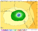
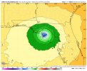
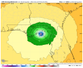
Also, that eye is so small.

Timhsv
Member
For Posterity :
NT45 KNHC 300259
TCDAT5
Hurricane Idalia Discussion Number 14
NWS National Hurricane Center Miami FL AL102023
1100 PM EDT Tue Aug 29 2023
Satellite and NWS radar imagery show that Idalia is becoming
increasingly more organized. The eye on the Tampa WSR-88D is
becoming better defined and the cloud pattern on GOES 16 imagery
consists of a growing Central Dense Overcast with a strong
convective band over the eastern semicircle of the circulation.
Reconnaissance aircraft measurements show that the central pressure
is steadily falling and is now around 958 mb. Flight-level and
SFMR-observed winds along with Doppler velocity data from the
aircraft support an intensity of 95 kt for this advisory.
Idalia is now moving faster toward the north or slightly east of
north with a motion estimate of 010/16 kt. The hurricane is moving
between a mid-level trough over the northwestern Gulf of Mexico and
ridge over the Bahamas and Greater Antilles. The system is expected
to turn north-northeastward within the next 12 hours, make landfall
along the northeastern Gulf coast, and then move northeastward to
eastward on the southern side of a mid-level trough moving off the
northeast U.S. coast. The 12-hour track forecast point for this
advisory has been nudged a bit westward, a little west of the model
consensus, but close to the latest GFS and ECMWF solutions. It
should be noted that some credible models, i.e. the HAFS-A and
HAFS-B predictions, are even a little father west.
After landfall, Idalia is expected to move near or along the coast
of Georgia and the Carolinas in 24-36 hours. Uncertainty in the
track forecast beyond 48 hours remains quite large, with some of
the global models turning Idalia southward, while some of the
regional hurricane models show the storm moving out to sea. Given
the uncertainties, the official track forecast shows a slow
southeastward motion in 4 to 5 days.
Based on the current strengthening trend and the favorable
thermodynamic and oceanic conditions, significant strengthening
seems likely up to landfall. The new official intensity forecast
calls for Idalia to reach category 4 strength at landfall. This is
fairly close to the HAFS And HWRF regional hurricane model
simulations. After the center moves back over the Atlantic,
significant restrengthening is not anticipated at this time due to
the expectation of strong vertical west-southwesterly vertical wind
shear.
Dangerous winds are likely to spread well inland near the path of
Idalia due to its relatively fast forward motion.
KEY MESSAGES:
1. Catastrophic impacts from storm surge inundation of 12 to 16 feet
above ground level and destructive waves are expected somewhere
between the Wakulla/Jefferson County line and Yankeetown, Florida.
Life-threatening storm surge inundation is likely elsewhere along
portions of the Florida Gulf Coast where a Storm Surge Warning is in
effect. Residents in these areas should follow any advice given by
local officials.
2. There is the potential for destructive life-threatening winds
where the core of Idalia moves onshore in the Big Bend region of
Florida, with hurricane conditions expected elsewhere in portions of
the Hurricane Warning area along the Florida Gulf Coast. Strong
winds will also spread inland across portions of northern Florida
and southern Georgia near the track of the center of Idalia where
Hurricane Warnings are in effect. Residents in these areas should be
prepared for long-duration power outages. Damaging hurricane-force
winds are possible in portions of eastern Georgia and southeastern
South Carolina where Hurricane Watches are in effect.
3. Areas of flash, urban, and moderate river flooding, with locally
considerable impacts, are expected across the Florida Big Bend,
central Georgia and South Carolina, through eastern North Carolina
into Thursday.
FORECAST POSITIONS AND MAX WINDS
INIT 30/0300Z 27.7N 84.5W 95 KT 110 MPH
12H 30/1200Z 30.0N 83.9W 115 KT 130 MPH...ON COAST
24H 31/0000Z 32.3N 81.3W 70 KT 80 MPH...INLAND
36H 31/1200Z 33.5N 78.6W 50 KT 60 MPH...OVER WATER
48H 01/0000Z 33.8N 75.0W 50 KT 60 MPH
60H 01/1200Z 33.5N 72.5W 50 KT 60 MPH
72H 02/0000Z 32.9N 71.0W 45 KT 50 MPH
96H 03/0000Z 32.0N 69.4W 45 KT 50 MPH
120H 04/0000Z 31.0N 68.4W 45 KT 50 MPH
$$
Timhsv
Member

Justin Hindman Hindy
Member
I say 125 mph landfall
I've been watching this cam at an island resort just south of Tampa and noticed that the dark sea line in the background seems higher in the moonlight than it was a little earlier. Is it my imagination or could that be the main body of the surge (which definitely is coming in here now)?
I didn't notice it a couple hours ago, and then watching it now reminded me of a mountain in the distance and realized that"s how they sometimes describe a surge.

I didn't notice it a couple hours ago, and then watching it now reminded me of a mountain in the distance and realized that"s how they sometimes describe a surge.
Last edited:
- Thread starter
- #139
Casuarina Head
Member
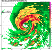
Tampa Bay was expected to receive 4–7’ of surge. Based on current images and videos the actual surge looks to be notably less. Also, the fact that the inner core is small and the forward speed rapid signifies to me the possibility that the peak surge in the Big Bend may be well below 16’. Finally, current radar indicates a pronounced dry-slot in the eastern semicircle, indicative of dry-air intrusion that is likely limiting not just intensification, but also the transfer of strong winds to the surface. (Incidentally, Ian suffered from the same and ended up producing surprisingly low winds on land, as evidence by in-situ observations, reconnaissance notwithstanding.) In fact the eastern part of the inner core is open: the eye itself is not fully closed off yet. Unless the eastern quadrant fills in and the wind-field expands (both of which could still happen), I think that Ida’s actual impacts are going to be much less severe than expected, both in Tampa Bay and along the Big Bend. Also, just a reminder: Camille and Betsy, each of which was a Category-4+ at landfall, both struck the Gulf Coast during El Niño, and others have too, so Idalia would not be unprecedented in this regard. So even if Idalia were to come in as a Cat-4+, which is still far from guaranteed, it would not be without precedent.
Last edited:
I wondered why there was moonlight occasionally at Cedar Grove -- dry slot. They're faring better than Cedar Key, with Idalia to their north now. It's probably just waves or deceptive shadows I saw, though will check the screenshots tomorrow. Cams are tricky at night even in calm weather.