Hurricane Category 4 Hurricane Helene

0z Hurricane models:


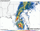
HWRF - 932 mb 140 mph into the eastern Big Bend
HMON - 932 mb 150 mph into just south of Tallahassee
HAFS-A - 942 mb 130 mph into just south of Tallahasssee
HAFS-B - 937 mb 140 mph into just east of Tallahassee
 
Recon hasn't been back in long, but it's looking like the storm may have strengthened since the last visit. Eye starting to clearly show up as well. May be a Category 2 now.
 
4 am discussion is interesting.

Helene is sending some mixed structural signals this morning. On one side, an Air Force Reserve Hurricane Hunter aircraft reports that the central pressure has fallen to near 966 mb, and satellite imagery shows the eye is trying to clear out. On another side, the aircraft reported concentric eyewalls of 16 and 32 n mi diameter, with the maximum flight-level winds, 80 kt at 700 mb, occurring about 50 n mi southeast of the center likely in relation to the outer eyewall. Based on the central pressure fall and the available data, the initial intensity is increased to 80 kt.

If I'm understanding this correctly, they're describing the possible start of eyewall replacement, since there are concentric eyewalls of different sizes?
 
Well now - that was a dramatic change since I went to sleep. We went from spiral bands to blob. Still having eye issues are we? GOOD. Hope that continues.
 
Well now - that was a dramatic change since I went to sleep. We went from spiral bands to blob. Still having eye issues are we? GOOD. Hope that continues.
grumpy cat GIF
 
Worried about folks in Tallahassee. Sounds like a lot of them don't understand just how serious this will be for them.
 
I think she's going to try to clear out the eye inside the bigger of the concentric eyewalls. New convection is firing all around that one, not the inner, if I'm seeing that correctly.
 

Attachments

  • floop-nam4km-2024092606.refcmp.us_se.gif
    floop-nam4km-2024092606.refcmp.us_se.gif
    1.8 MB · Views: 0
Last edited:
Differences remain in ensemble guidance. Won't make much of a difference for the Big Bend but will change impact levels further north.
1727356026411.png1727356029251.png1727356031520.png
 
She's really starting to get that "disk of doom" look to her. Top and east heavy, but rotating the blob around to surround the eye better. Everything smoothing out - she's speeding up.
 
There will be no - I repeat, NO chasers needed to document a 12-18ft storm surge. If you don't have a remote camera or a well elevated SOLID structure to retreat to already mapped out, do not attempt to chase this. You hear me Brett Adair? ;) LOL.

View attachment 30220
*upside-down smiley face emoji*
1727356690854.png

Also, Sarasota has street fish.
 
*upside-down smiley face emoji*
View attachment 30274
I think I'd be moving inland for any chase. Too much risk for a good intercept on the coast except in a high rise hotel maybe where one can be above the water and strong enough for the winds. Even then, I wouldn't want to be stuck in the landfall zone for days after. It's not fun.
 
Back
Top