
jmills
Member
I know I'm a little late, but COD is almost always going to be faster than SPC.
Follow along with the video below to see how to install our site as a web app on your home screen.
Note: This feature may not be available in some browsers.
Wow....thats pretty bold to say for the NWS. They usually don't say stuff like that publicly.The bmx office said their forecasts were suffering by aligning with the SPC. They told media partners to expect these differences to continue.
To be completely fair the SPC dropped the ball quite a few times in the last year, and whenever they do they and the NWS seem to get slammed by the public. Most people don't understand that these sorts of forecasts are incredibly tricky. Even when the storms are hours away there can be last-minute variables that completely change the stage for events later in the day. Sometimes that means a bust, sometimes an over-performer. But for some reason people generally don't seem to get that.Wow....thats pretty bold to say for the NWS. They usually don't say stuff like that publicly.
Wow....thats pretty bold to say for the NWS. They usually don't say stuff like that publicly.
The bmx office said their forecasts were suffering by aligning with the SPC. They told media partners to expect these differences to continue.
It's setups like this one, with much uncertainty and model disagreement, that I don't envy being a degreed meteorologist whose task is to warn tons of thousands of people about severe weather.
Armchair forecasting is much less stressful :]
To be completely fair the SPC dropped the ball quite a few times in the last year, and whenever they do they and the NWS seem to get slammed by the public. Most people don't understand that these sorts of forecasts are incredibly tricky. Even when the storms are hours away there can be last-minute variables that completely change the stage for events later in the day. Sometimes that means a bust, sometimes an over-performer. The problem is that generally people have a hard time understanding that.Wow....thats pretty bold to say for the NWS. They usually don't say stuff like that publicly.
Waff and Brad Travis have really built this up all week. I don’t think there was this many Facebook lives and what not for the March storm. I was worried this may be a dud for North Alabama with the morning line but with it slowing down we may get those discrete cells popping out in front of the line. I may be wrong but I recall people saying the 89 Tornado in Huntsville was a result of the supercell merging with the squall line as it came through. I feel like usually the opposite is true and this lowers the tornado threat. Anyone know more about this?
...SUMMARY...
Strong to severe storms are expected across the lower Mississippi
Valley and central Gulf Coast States with a threat for damaging
winds and a few tornadoes, some possibly strong. Isolated severe
storms will be possible in the Midwest Saturday afternoon to early
evening.
Given the strength of the
southerly low-level jet (50-60 kt) and low-level shear, strong/
damaging winds (some significant) and a strong tornado or two will
be possible from southeast LA through eastern MS and western AL
Saturday afternoon into the evening.
I am trying to understand the placement of the hatched area...seems a little too far west to me...I would think the outflow boundary would be well into the western part of that area...at least in northern sectionsThe new SPC Day 2 Outlook added a hatched area across portions of southeast LA, east MS, and west AL:
A couple of snippets from the discussion:
http://www.spc.noaa.gov/products/outlook/day2otlk.html
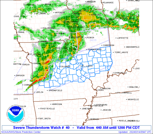
I am trying to understand the placement of the hatched area...seems a little too far west to me...I would think the outflow boundary would be well into the western part of that area...at least in northern sections