KCweatherboy
Member
Yeah MGM is Montgomery, so a bit further south than the big AL tornadoes of that eventMGM is Montgomery right? Wow
Follow along with the video below to see how to install our site as a web app on your home screen.
Note: This feature may not be available in some browsers.
Yeah MGM is Montgomery, so a bit further south than the big AL tornadoes of that eventMGM is Montgomery right? Wow
I don’t think I’ve ever saw a 4/3/74 analog. When was the last lead up event that some models were showing that as an analog?
I’m a recent weather enthusiast(2-3 years) but I can’t imagine that’s something you see every day
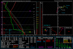
(Are You Ready) Do the Super OutbreakFound a 18Z at Nashville 4/3/74 analog...on a forecast sounding in Iowa.
Slightly off topic. What were some of the CAPE/shear/SRH values like on 4/3/74?Found a 18Z at Nashville 4/3/74 analog...on a forecast sounding in Iowa. Jonesboro 5/4/03 is on there too, although verbatim this one is rather capped.
(Are You Ready) Do the Super Outbreak
Slightly off topic. What were some of the CAPE/shear/SRH values like on 4/3/74?
Yeah I've seen a lot of 4 May 2003 analogs, which is concerning to say the least.Of course we know Super Outbreaks are extremely rare, but at this stage this does have the feel of some of the other higher-end, widespread central CONUS outbreaks like 3/12 and 4/2/2006, or 5/4/2003. Just a huge area under the gun both N-S and W-E.
5/4/2003 had 4 F4s that day and 79 confirmed tornadoes. YikesOf course we know Super Outbreaks are extremely rare, but at this stage this does have the feel of some of the other higher-end, widespread central CONUS outbreaks like 3/12 and 4/2/2006, or 5/4/2003. Just a huge area under the gun both N-S and W-E.
Yeah one them was in my town jackson tn. Killed 235/4/2003 had 4 F4s that day and 79 confirmed tornadoes. Yikes
Ah. Have you known of any photos of that or the 1999 one? (Tornado, not damage)Yeah one them was in my town jackson tn. Killed 23
Once again, you are making way too many assumptions. No one was seriously comparing this to 4/3/74The ML signature at 00Z 4 Apr has been looking less impressive on the past two EPS runs. I see potential VBV issues in future soundings...
If so, this goes to show why one should never bring up once-a-generation outbreaks at D7...
It is hard to tell the difference sometimes on these here Internets...and for the record even I was a bit guilty at times in regard to 3 Apr ’74.Once again, you are making way too many assumptions. No one was seriously comparing this to 4/3/74
Way to early in the game to worry about vbv… main thing the big pitcher. Showing a potential major severe outbreak at this juntxureThe ML signature at 00Z 4 Apr has been looking less impressive on the past two EPS runs. I see potential VBV issues in future soundings...
If so, this goes to show why one should never bring up once-a-generation outbreaks (i.e., the ’74 Super Outbreak) at D7...

Day 4-8 Convective Outlook CORR 1
NWS Storm Prediction Center Norman OK
0407 AM CDT Fri Mar 31 2023
Valid 031200Z - 081200Z
CORRECTED TYPOS IN TEXT
...DISCUSSION...
Medium-range models indicate that mid/upper flow will undergo
substantial amplification across the northern and middle latitudes
of the Pacific during this period. This appears likely to include
the evolution of a broad, deep mid-level trough which will support
strong cyclogenesis to the southeast of the Aleutians by the end of
next week. Downstream flow is then forecast to split near the North
American Pacific coast, with ridging building across the far western
Canadian provinces and troughing across the U.S. Great Basin and
Southwest, before converging into broad troughing across the
northwestern Atlantic.
Prior to these developments, a significant mid-level short wave
trough is forecast to emerge from the Intermountain West Monday into
early Tuesday, before contributing to strong cyclogenesis across the
central Great Plains into the Upper Midwest Tuesday through Tuesday
night. The mid-level perturbation may be accompanied by a 100 kt
cyclonically curved 500 mb jet, contributing to strong deep-layer
shear across the warm sector of the surface cyclone, where
intensifying southerly 850 mb flow may contribute to large,
clockwise curved low-level hodographs.
The GFS, ECMWF and their respective ensembles seem to be coming in
better agreement with the late afternoon and early evening track of
the surface cyclone across the northeastern Kansas into southeastern
Nebraska vicinity, with a warm front extending across southern Iowa
and the dryline trailing from the surface low southward near the
Missouri/Kansas border. The dryline may become the focus for the
initiation of strongest storms, which will tend to propagate
northeastward before being overtaken by a surging cold front.
There is some concern that a more subtle mid-level impulse may
contribute to thunderstorm initiation within the open warm sector,
across parts of the Ozark Plateau early in the day, and negatively
impact destabilization across that area, and perhaps areas to the
north. However, if this does not become a mitigating factor, a
substantive organized severe weather event may evolve, including
potential for strong tornadoes, large hail and damaging wind gusts
Tuesday afternoon into Tuesday night across the lower Missouri
Valley vicinity.
..Kerr.. 03/31/2023
What is this from?There is some concern that a more subtle mid-level impulse may
contribute to thunderstorm initiation within the open warm sector,
across parts of the Ozark Plateau early in the day, and negatively
impact destabilization across that area, and perhaps areas to the
north. However, if this does not become a mitigating factor, a
substantive organized severe weather event may evolve,
Interesting..
From @WxMan42711 post above from the SPC discussionWhat is this from?