- Moderator
- #141
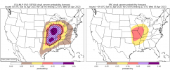
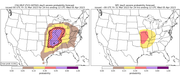
I know no one wants to see this after today, but this is the CSU-MLP for next Tuesday/Wednesday.
Follow along with the video below to see how to install our site as a web app on your home screen.
Note: This feature may not be available in some browsers.
Same areas as yesterday.Oh my gosh... never seen high risk probs on CSU MLP farther out than Day 2 on CSU.

SPC is already mentioning strong/long-track tornadoes in the discussion for Day 4
Geez. Spring really kicking off with a bang this year.Oh my gosh... never seen high risk probs on CSU MLP farther out than Day 2 on CSU.
After Tuesday models seem to be quietening down so let's hope for that... but still have a lot to get through before that happens.Geez. Spring really kicking off with a bang this year.
Yeah after Tuesday Wednesday system . We look to have a 7’to 10 day window of quiet weather before go back to severe pattern mid April.After Tuesday models seem to be quietening down so let's hope for that... but still have a lot to get through before that happens.
What most are still saying this morning from the professionals… that this was just appetizer to this upcoming weekGoing into yesterday I was sort of of the mindset that yesterday was the appetizer and Tuesday was going to be the main course, so hopefully that doesn't end up being the case.
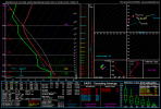
Pretty good model agreement on a substantial threat without a lot of obvious caveats. Some of the forecast soundings I pulled from Missouri on Tuesday afternoon/evening had some capping issues present but otherwise I don't see an obvious failure mode.What most are still saying this morning from the professionals… that this was just appetizer to this upcoming week
Yeah, I kept seeing those same inversions/caps on the models for yesterday’s event, specifically the NAM. So I wonder if this is synoptically similar right now?Pretty good model agreement on a substantial threat without a lot of obvious caveats. Some of the forecast soundings I pulled from Missouri on Tuesday afternoon/evening had some capping issues present but otherwise I don't see an obvious failure mode.
Yeah, I kept seeing those same inversions/caps on the models for yesterday’s event, specifically the NAM. So I wonder if this is synoptically similar right now?
I think you and I briefly discussed those before the event really kicked off.
The southern (and even one of the cells in the north) cells ability to stay discrete basically the entire event yesterday was extremely surprising.The cap is key...(along with the strength/type of forcing). Seems to be a small sweet spot that allows for sustained, open warm sector supercells without snuffing them out, yet not allowing for quick upscale growth before they can organize and produce tornadoes. Yesterday struck that rare balance.