
Navigation
Install the app
How to install the app on iOS
Follow along with the video below to see how to install our site as a web app on your home screen.
Note: This feature may not be available in some browsers.
More options
-
Welcome to TalkWeather! We see you lurking around TalkWeather! Take the extra step and join us today to view attachments, see less ads and maybe even join the discussion. CLICK TO JOIN TALKWEATHER
You are using an out of date browser. It may not display this or other websites correctly.
You should upgrade or use an alternative browser.
You should upgrade or use an alternative browser.
Severe Weather Threat - November 3rd-6th, 2022
- Thread starter Taylor Campbell
- Start date
-
- Tags
- severe
Horrific night.
Let's all pray that casualities (and fatalities especially) are kept to as much of a minimum as possible.

Lake Martin EF4
Member
I believe there are seven reported fatalities from Powderly alone.Let's all pray that casualities (and fatalities especially) are kept to as much of a minimum as possible.
Yeah that’s the video I was describing, but apparently that’s from Powderly from what I saw. Could he wrong though.Not looking good at all in Idabell...
View attachment 15395
Tomcats Forever!
Member
Would have already been dark in Idabel, wouldn't it?Yeah that’s the video I was describing, but apparently that’s from Powderly from what I saw. Could he wrong though.
Yes I believe so. I’ve heard homes are destroyed in Idabel, but I haven’t seen any damage imagery from that town yetWould have already been dark in Idabel, wouldn't it?
Looks like the storms may be lining out.
In addition, There's quite a lot of Flash Flood Warnings being issued behind the line. If you're in the storm-affected region, please take care to avoid getting caught up in a flash flood!
In addition, There's quite a lot of Flash Flood Warnings being issued behind the line. If you're in the storm-affected region, please take care to avoid getting caught up in a flash flood!
- Thread starter
- Moderator
- #188
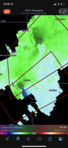
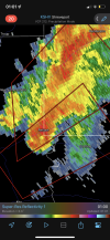
Large and extremely dangerous tornado confirmed near Ben Lomond, AR.
Bevo
Member
Texarkana now under a tornado warning.
TornadoFan
Member
BWER north of Cushing.
Austin Dawg
Member
Ryan is one of my favorite guys I watch on YouTube. His recovery work after storms is phenomenal.Ryan Hall has good live coverage on YouTube currently
Sent from my iPhone using Tapatalk
Austin Dawg
Member
Ryan getting unsubstantiated information that Idabell has damage on the F4 or higher scale
Shakespeare 2016
Member
I doubt if New Boston, TX faired any better. Both of those tornadoes were absolute monsters.Ryan getting unsubstantiated information that Idabell has damage on the F4 or higher scale


TH2002
Member
- Messages
- 4,974
- Reaction score
- 11,116
- Location
- California, United States
- Special Affiliations
- SKYWARN® Volunteer
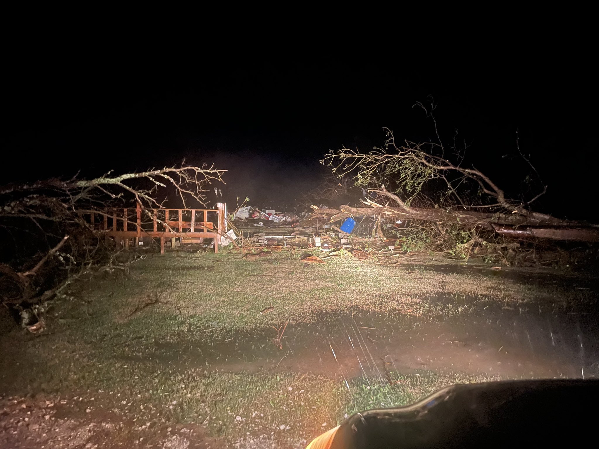
South of Idabel. Homes leveled.

Lake Martin EF4
Member
I see bare slab. Granted not fully swept clean but definitely visible. New Boston might not be the only EF5 candidate tonight.South of Idabel. Homes leveled.