TH2002
Member
- Messages
- 4,974
- Reaction score
- 11,116
- Location
- California, United States
- Special Affiliations
- SKYWARN® Volunteer

Follow along with the video below to see how to install our site as a web app on your home screen.
Note: This feature may not be available in some browsers.
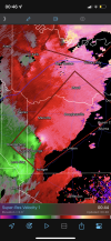
That's absolutely insane...HUGE debris sig now SW of New Boston, over 20,000 feet.
Sent from my SM-S901U using Tapatalk
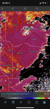
Looks like it may have dropped directly over Hughes Springs.Looks like a new tornado is forming NE of Daingerfield.