• Welcome to TalkWeather!
    We see you lurking around TalkWeather! Take the extra step and join us today to view attachments, see less ads and maybe even join the discussion.
    CLICK TO JOIN TALKWEATHER

Severe Weather Threat - November 3rd-6th, 2022

Taylor Campbell

Moderator
Moderator
PerryW Project Supporter
Messages
2,199
Reaction score
2,385
Location
Wedowee, AL
Special Affiliations
  1. SKYWARN® Volunteer
A significant severe weather threat with all modes of severe over a large area looks likely across the central and southern Plains Thursday-Friday. The operational trends have been towards a more favorable setup and the ensemble support has largely grown in favor of the heightened threat.
 

KevinH

Member
Messages
1,954
Reaction score
3,139
Location
West Central GA
A significant severe weather threat with all modes of severe over a large area looks likely across the central and southern Plains Thursday-Friday. The operational trends have been towards a more favorable setup and the ensemble support has largely grown in favor of the heightened threat.
I am glad Dixie (AL/GA) will be sitting this one out. I am not ready (yet)!
 

Austin Dawg

Member
Messages
922
Reaction score
1,439
Location
Leander, Texas
Models are agreeing that this is gonna be messy in my neck of would especially to my west here in Texas. Most of the year has been rather quiet. I hope this is a bust. We've been lucky with most of the systems have created a line of storms that wouldn't allow one supercell to go by itself become dangerous and we also not had any isolated, supercells out in front of the storm system. I hope it stays that way.
 

JPWX

Member
Messages
1,948
Reaction score
5,290
Location
Smithville MS
Don't be surprised if parts of Arkansas down into Louisiana and into Mississippi get put under a Marginal Risk on Saturday.
 
  • Thread starter
  • Moderator
  • #5

Taylor Campbell

Moderator
Moderator
PerryW Project Supporter
Messages
2,199
Reaction score
2,385
Location
Wedowee, AL
Special Affiliations
  1. SKYWARN® Volunteer
The EURO, NAM, and GFS products have unusually strong agreement for an environment supportive of an enhanced threat of severe weather along the I-35 corridor eastward in Texas on Friday with Dallas, TX being in the thick of things.
 
  • Thread starter
  • Moderator
  • #6

Taylor Campbell

Moderator
Moderator
PerryW Project Supporter
Messages
2,199
Reaction score
2,385
Location
Wedowee, AL
Special Affiliations
  1. SKYWARN® Volunteer
I wonder if we will get a special day 3 outlook update. I think the slight risk was well underdone.

22FD8DE9-D5EB-4DD2-8ED6-C2B736858A5C.gif
 

JBishopwx

Member
Sustaining Member
Messages
1,014
Reaction score
2,392
Location
Ackerman, MS
Special Affiliations
  1. SKYWARN® Volunteer
  • Thread starter
  • Moderator
  • #8

Taylor Campbell

Moderator
Moderator
PerryW Project Supporter
Messages
2,199
Reaction score
2,385
Location
Wedowee, AL
Special Affiliations
  1. SKYWARN® Volunteer
The QLCS looks capable of producing a lot of significant tornadoes. I’d expect a moderate risk upgrade if everything upholds and the high res models follow suit.
 
  • Thread starter
  • Moderator
  • #11

Taylor Campbell

Moderator
Moderator
PerryW Project Supporter
Messages
2,199
Reaction score
2,385
Location
Wedowee, AL
Special Affiliations
  1. SKYWARN® Volunteer
Yeah, all the model data is looking obviously intense for a big day!

A95-CA04-D-FD56-4-CAE-B35-F-B5-F72-B307019.png


E65E4F1A-2418-4BC5-B832-EB4FF058DB0C.png
 
Last edited:

Austin Dawg

Member
Messages
922
Reaction score
1,439
Location
Leander, Texas
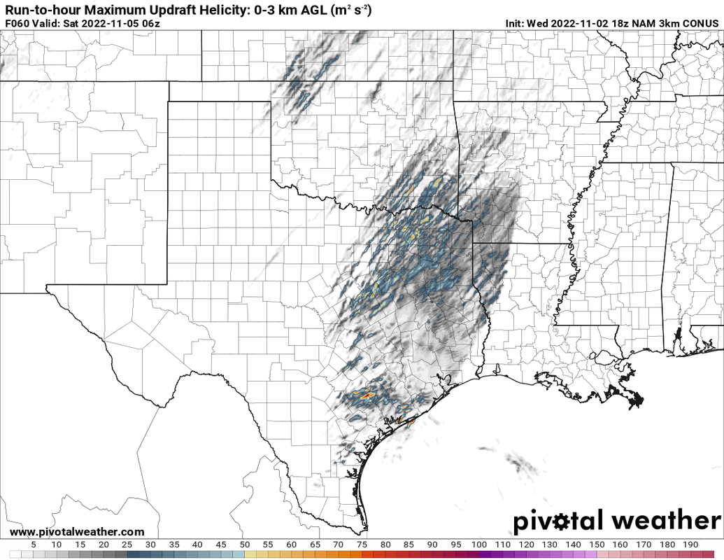
NAM and NAM 3k are scary as hell.
I live in Jarrell, we just had a pretty strong storm come in last week and they are now switching a football game to Thursday in preparation of the one possible Friday/Saturday. Interested to see what happens!
I'm in Leander and the models are looking dire from here to the ARKLATEX. The Enhanced area keeps creeping our way with each update.

It does look like it will pass thru here before to late but the folks NE of here may be in for a long night.
 

cincywx

Member
Messages
666
Reaction score
1,369
Location
Cincinnati, OH
Special Affiliations
  1. SKYWARN® Volunteer
DAY 2 CONVECTIVE OUTLOOK
NWS STORM PREDICTION CENTER NORMAN OK
1229 PM CDT THU NOV 03 2022

VALID 041200Z - 051200Z


...THERE IS AN ENHANCED RISK OF SEVERE THUNDERSTORMS OVER MUCH OF
EASTERN/NORTHEASTERN TEXAS...SOUTHEAST OKLAHOMA...SOUTHWEST
ARKANSAS...AND NORTHERN LOUISIANA...

..SUMMARY


SEVERE THUNDERSTORMS ARE LIKELY FRIDAY INTO FRIDAY NIGHT CENTERED
OVER PARTS OF NORTHERN AND EASTERN TEXAS, EASTERN OKLAHOMA,
SOUTHWEST ARKANSAS AND WESTERN LOUISIANA. SEVERAL TORNADOES ARE
POSSIBLE OVER TEXAS WITH DAMAGING WINDS SPREADING INTO ARKANSAS AND
LOUISIANA OVERNIGHT. A STRONG TORNADO OR TWO MAY OCCUR FROM LATE
AFTERNOON INTO EARLY EVENING.

..SYNOPSIS


AN UPPER TROUGH OVER NM WILL DEEPEN AND PIVOT NORTHEASTWARD ACROSS
NORTHERN TX, OK AND KS DURING THE DAY, THEN TOWARD THE MID MS VALLEY
BY 12Z SATURDAY. COINCIDENT WITH THIS WAVE WILL BE A STRENGTHENING
MID AND UPPER-LEVEL SPEED MAX WITH STRONG COOLING ALOFT FROM THE TX
PANHANDLE INTO KS.

AT THE SURFACE, A COLD FRONT SHOULD EXTEND ROUGHLY FROM EASTERN IA
INTO SOUTHEAST KS AND TO A LOW OVER SOUTHWEST OK AT 12Z FRIDAY, WITH
GRADUAL DEEPENING OF THE SURFACE TROUGH FROM MO INTO NORTHEAST TX
THROUGH 00Z. SOUTHERLY SURFACE WINDS AHEAD OF THE COLD FRONT AS WELL
AS A BROAD ZONE OF 40-50 KT SOUTHWESTERLY 850 MB WINDS WILL AID
MOISTURE ADVECTION, WITH 68-72 F DEWPOINTS SOUTH OF THE RED RIVER,
AND LOW 60S F INTO SOUTHERN MO. THE END RESULT WILL BE A REGION OF
FAVORABLE INSTABILITY, SHEAR AND LIFT FROM EASTERN TX AND OK INTO
WESTERN AR AND LA, WITH A THREAT OF SEVERAL TORNADOES AND DAMAGING
WINDS.

..TX...OK...AR...LA


SCATTERED STORMS ARE EXPECTED TO BE ONGOING NEAR AND NORTH OF A COLD
FRONT FROM NORTHWEST OK INTO EASTERN KS, WITH STRONG DEEP-LAYER
SHEAR AND COLD TEMPERATURES ALOFT FAVORING HAIL. GIVEN THE
FRONT-PARALLEL NATURE TO THE WINDS ALOFT, THESE STORMS MAY BECOME
ELEVATED AS THE FRONT UNDERCUTS THE CONVECTION. ISOLATED DAMAGING
GUSTS COULD OCCUR IMMEDIATELY ALONG THE BOUNDARY.

TO THE SOUTH, MOISTURE AND INSTABILITY WILL INCREASE THROUGHOUT THE
DAY AHEAD OF THE COLD FRONT IN TX. AS PRESSURES FALL, BOUNDARY-LAYER
WINDS WILL BECOME INCREASINGLY CONFLUENT ALONG THE I-35 CORRIDOR,
WITH DEEPENING MOIST PROFILES. FORECAST SOUNDINGS INDICATE THAT THE
CAPPING INVERSION WILL NOT BE VERY STRONG. AS A RESULT, INCREASING
LARGE-SCALE LIFT WILL LIKELY LEAD TO PRE-FRONTAL STORMS AFTER 19-20Z
OVER MUCH OF NORTHERN TX INTO SOUTHEAST OK. STRONG DEEP-LAYER SHEAR
AND MLCAPE OF 1500-2000 J/KG WILL FAVOR DISCRETE CELLS, A FEW OF
WHICH MAY MATURE INTO TORNADIC SUPERCELLS AS SRH INCREASES TO AROUND
300 M2/S2 BY 00Z.
OTHER ISOLATED SUPERCELLS ARE POSSIBLE FARTHER
SOUTHWESTWARD INTO CENTRAL TX AS THE COLD FRONT APPROACHES THE
INSTABILITY AXIS. LOW-LEVEL SHEAR WILL NOT BE AS STRONG FARTHER
SOUTH, BUT SUPERCELLS WILL STILL BE POSSIBLE, INCLUDING THE THREAT
OF LOCALLY DAMAGING HAIL.

DURING THE EVENING AND OVERNIGHT, THE COLD FRONT WILL MERGE WITH ANY
EXISTING WARM SECTOR ACTIVITY, WITH A SEVERE SQUALL LINE FORECAST.
DAMAGING WINDS AND BRIEF TORNADOES WILL BE POSSIBLE OVER EASTERN TX,
WESTERN LA AND AR, AND EASTERN OK. OTHER SEVERE STORMS MAY OCCUR
FROM NORTHERN AR INTO SOUTHERN MO, WHERE SHEAR WILL BE VERY STRONG,
BUT INSTABILITY MINIMAL. SPORADIC WIND DAMAGE MAY OCCUR OVERNIGHT IN
THESE AREAS.

..JEWELL.. 11/03/2022
 

TH2002

Member
Sustaining Member
Messages
3,961
Reaction score
6,831
Location
California, United States
Special Affiliations
  1. SKYWARN® Volunteer
I know all eyes are on tomorrow, but a pretty impressive supercell has quickly developed south of Hays, KS - perfect time for DDC's radar to go down.
 

Bevo

Member
Messages
280
Reaction score
272
Location
Dallas, TX
Today was so soupy outside and I'm sure tomorrow will be even more so...it definitely has that sinister vibe to it. Feels wrong for November.
I'm hoping if things pop off tomorrow, it's well outside any population centers.
 
  • Thread starter
  • Moderator
  • #20

Taylor Campbell

Moderator
Moderator
PerryW Project Supporter
Messages
2,199
Reaction score
2,385
Location
Wedowee, AL
Special Affiliations
  1. SKYWARN® Volunteer
A moderate risk should come out with the next update. Nadocast is respectively upping the odds. This region has looked prime for numerous severe thunderstorms with a significant tornado risk. Things look to fire around lunch tomorrow and turn most sour through the afternoon and into the night.

1EFC240E-A3D0-436A-905E-08C24E24CCBB.png
 
Last edited:
Back
Top