X
Xenesthis
Guest
Well I can’t imagine much will be said here. If there is no storms that form in advance of the line then just QLCS tornadoes/wind would be the main threat... so basically maybe some spin ups
Follow along with the video below to see how to install our site as a web app on your home screen.
Note: This feature may not be available in some browsers.
I am sure a tornado watch will be posted but nothing of special noteMeso... statements bout possible watches going be needed or not ....
I am sure a tornado watch will be posted but nothing of special note

Also the fact that TN has been cloud free for the most part doesn’t mean muchLast few runs the HRR has been upping the 0-3 km hel values for areas north and along of I59...got to watch for clearing/cloud lines as that could act as a trigger for cells advance of the front.
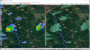
A clearing line is advancing northward.
I have to keep reminding myself dst has ended so daylight is now very limited in the afternoon, the clearing line prob won't matter muchAlso the fact that TN has been cloud free for the most part doesn’t mean much
It has a long way to go to get to TNYou can see where the warm juicy air is on the surface obs: right now it's along the line from Vicksburg to Jackson to Meridian, which is about where mesoanalysis shows the 500 j/kg CAPE threshold. Slightly warmer in NW Mississippi where the sun has been out for a fair amount of the day (71 at Greenville vs. 68 at Greenwood). I guess we'll see how far north it gets in the next 3-6 hours.

Now is this expected to propogate NE as the storm moves east? In other words should I expect the probability of a tornado watch shift NE into TN with the overnight hours
Yeah wow, these little guys already want to be supercells. Now the question is are the dynamics already in place to sustain them or will the warmer midlevel air kill them off?
Yeah wow, these little guys already want to be supercells. Now the question is are the dynamics already in place to sustain them or will the warmer midlevel air kill them off?