warneagle
Member
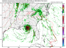
Unsurprising given the satellite presentation:
BULLETIN
Hurricane Michael Advisory Number 13
NWS National Hurricane Center Miami FL AL142018
400 PM CDT Tue Oct 09 2018
...MICHAEL STRENGTHENS TO A MAJOR HURRICANE...
...LIFE-THREATENING STORM SURGE...HURRICANE FORCE WINDS...AND HEAVY
RAINFALL EXPECTED ALONG THE NORTHEASTERN GULF COAST...
SUMMARY OF 400 PM CDT...2100 UTC...INFORMATION
----------------------------------------------
LOCATION...26.0N 86.4W
ABOUT 295 MI...470 KM S OF PANAMA CITY FLORIDA
ABOUT 270 MI...435 KM SSW OF APALACHICOLA FLORIDA
MAXIMUM SUSTAINED WINDS...120 MPH...195 KM/H
PRESENT MOVEMENT...N OR 350 DEGREES AT 12 MPH...19 KM/H
MINIMUM CENTRAL PRESSURE...957 MB...28.26 INCHES