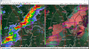
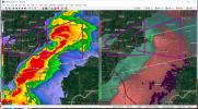
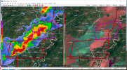
• Welcome to TalkWeather!
    We see you lurking around TalkWeather! Take the extra step and join us today to view attachments, see less ads and maybe even join the discussion.
    CLICK TO JOIN TALKWEATHER

Archive Severe Potential 4/3-4/4

Messages
2,834
Reaction score
4,559
Location
Madison, WI
Cell north of Marion, IL is trouble as well. More in eastern AR headed toward western TN.
 

Attachments

  • PAH_2226_wide.png
    PAH_2226_wide.png
    1.5 MB · Views: 0

buckeye05

Member
Messages
3,158
Reaction score
4,712
Location
Colorado
String of 7 tornado warned supercells from Indiana to Arkansas. Wow.
Confirmed damaging tornado near Veedersburg, IN btw.
 
Messages
587
Reaction score
411
Location
St. Catharines, Ontario
bvDB2A9.png

Near West Frankfort, Illinois a few minutes ago, possible rain wrapped tornado. At the very least it seems to be thinking about dropping one. Tight rotation on the stream.
 

Equus

Member
Messages
3,295
Reaction score
3,380
Location
Jasper, AL
Special Affiliations
  1. SKYWARN® Volunteer
Judging by the storm report page alone this is already shaping up to be a SIGNIFICANT event and things have yet to really move into the MDT area.
 

Bama Ravens

Member
Messages
1,210
Reaction score
656
Location
Morris, AL (Northern Jefferson County)
NWS Memphis needs to fix their tornado warning text. For the last three or four events, going back to early March, every warning they issue says a “severe thunderstorm producing a tornado” instead of “capable of producing a tornado.” This has been happening on storms that have showed no indication of producing a tornado, and the text says nothing about any sort of confirmation.
 
Messages
587
Reaction score
411
Location
St. Catharines, Ontario
NWS Memphis needs to fix their tornado warning text. For the last three or four events, going back to early March, every warning they issue says a “severe thunderstorm producing a tornado” instead of “capable of producing a tornado.” This has been happening on storms that have showed no indication of producing a tornado, and the text says nothing about any sort of confirmation.
I agree, it confuses the issue and could end up having a cry wolf effect on some people. Saying that it's capable of producing a tornado is for most people, very different from saying it actually is producing a tornado.

Another issue I've noticed is that when a PDS warning or an emergency is issued, some NWS offices say "large and extremely dangerous tornado", and others say "destructive tornado". I personally prefer the second, since strong/violent tornadoes can be pretty narrow (Niles, Pampa, and Elie come to mind).
 
Messages
2,834
Reaction score
4,559
Location
Madison, WI
Funnel cloud reported with that storm coming through the MO bootheel about to cross the MS.
 

Attachments

  • NQA_2321.png
    NQA_2321.png
    1.3 MB · Views: 0
Logo 468x120
Back
Top