• Welcome to TalkWeather!
    We see you lurking around TalkWeather! Take the extra step and join us today to view attachments, see less ads and maybe even join the discussion.
    CLICK TO JOIN TALKWEATHER

Significant Tornado Events


New video by TornadoTRX - this video just makes me further question how this storm wasn’t given a higher rating.

This is an incredibly old post but I wanted to give some insight!
From what I've gathered, the NWS actually really wanted, or at least implied they wanted to give this one a higher rating. I spoke with some people internally, including the MIC for Lubbock, who expressed how limited their resources were when actually analyzing the event, and how hopefully a revision of scale will include external measurements and remote sensing to aid in ratings.

It's interesting to note there are some unwritten rules about tornado damage ratings. I initially was confused why Matador was not rated EF4 based on tree damage (DOD 5 Hardwood UB (167 MPH). It seems though, tornadoes are unable to have EF4 tree damage rated unless a structure also supports that rating, pretty interesting. Tim Marshall was part of the survey team for Matador, he had comments to say too, such as that some homes "had sporadic bolting of plate. Some bolts had nuts and washers while others did not." Which would put essentially every structure at a LB (Lower bound) DI.

The biggest head scratcher (and is still so even after talking to as many people as I could) is that the Dollar General in matador was completely flattened and mangled, in similar fashion to the Dollar General in Marietta, OK rated EF4 this year, and other dollar stores like in Rolling Fork, MS. Tim Marshall even commented "Bolt securing column base plate was pulled out of the concrete foundation. Also note the grass packing indicating winds were still quite strong after the building failed." So I really have no clue why this was overlooked as an EF4 DI. Who knows. Glad people in here found the video helpful. :)
Not trying to sound like a super fan right now lol, but wanted to tell you that your videos are always super intriguing and fascinating to tune into and keep up the great work. Really enjoyed the Bridge Creek documentary you made a couple of weeks ago.
 
This is an incredibly old post but I wanted to give some insight!
From what I've gathered, the NWS actually really wanted, or at least implied they wanted to give this one a higher rating. I spoke with some people internally, including the MIC for Lubbock, who expressed how limited their resources were when actually analyzing the event, and how hopefully a revision of scale will include external measurements and remote sensing to aid in ratings.

It's interesting to note there are some unwritten rules about tornado damage ratings. I initially was confused why Matador was not rated EF4 based on tree damage (DOD 5 Hardwood UB (167 MPH). It seems though, tornadoes are unable to have EF4 tree damage rated unless a structure also supports that rating, pretty interesting. Tim Marshall was part of the survey team for Matador, he had comments to say too, such as that some homes "had sporadic bolting of plate. Some bolts had nuts and washers while others did not." Which would put essentially every structure at a LB (Lower bound) DI.

The biggest head scratcher (and is still so even after talking to as many people as I could) is that the Dollar General in matador was completely flattened and mangled, in similar fashion to the Dollar General in Marietta, OK rated EF4 this year, and other dollar stores like in Rolling Fork, MS. Tim Marshall even commented "Bolt securing column base plate was pulled out of the concrete foundation. Also note the grass packing indicating winds were still quite strong after the building failed." So I really have no clue why this was overlooked as an EF4 DI. Who knows. Glad people in here found the video helpful. :)
I spoke with Marshall after this event, and he more or less admitted that the non-structural (contextual) damage pointed to a rating higher than what was assigned, but that the poor construction quality was the main driving force behind the rating. Although, I never got an explanation to why one particular home on the north side of town wasn't given EF4 despite it being more than qualified for such a rating.
 
One thing about Guin I'm curious about is how despite being fast-moving, rain-wrapped, nocturnal and an F5 is the rather low fatality count (28). I'd expect something much higher given the circumstances, the 'nocturnal' part in particular.
There is a video on Youtube, made by a tv station, that talked to a survivor. In it, it mentions elderly people heading to a storm shelter at 4:00 p.m., five hours before the tornado struck. if a lot of people had a foreboding, I wonder if that could account for a relatively low death toll, though to me, one death is too many
 
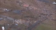
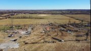
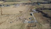
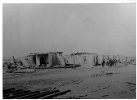
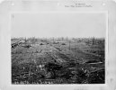
Yeah, in Franklin, Hamilton and White County, IL it seems to have been at its maxima, it's a shame that it's so hard to find damage photographs from those areas. What's impressive is that despite those 3 counties being entirely rural and with a low population density the tornado still managed to kill at least 65 farmers in Hamtion and White County. In fact, much of the Tri-State's path has the problem common to many older F5s, where the most extreme damage and hardest-hit areas were sparsely photographed. Always wondered why that is, perhaps empty foundations are less photogenic than damaged but still standing houses?

This post from page 1 by locomusic01 (wish he was still around) demonstrates examples of this: https://talkweather.com/threads/significant-tornado-events.1276/#post-31719 I recommend checking out the photos there has:

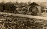
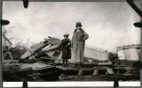
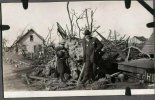
Quoting him directly: "Tri-State is another case where the photos are impressive, but still don't even show the most impressive damage accounts you can find. Like, this home in Bollinger County, MO, was destroyed and the damage is clearly intense, but it was also on the southern edge of the damage path. Just to the north, witnesses reported that trees were "reduced to naked stumps" and the grass was "stripped bare and scoured of several inches of soil."

Another quote: "The large and well-built home of Perry County District Judge Claus Stueve, near Frohna, was also largely swept away. Two people were killed and there was reportedly intense vegetation damage in the area, which you can sort of see in the photo."

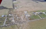
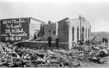
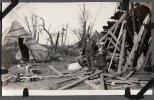
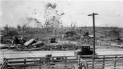
This post from another has a picture of White County, IL damage in which a house was so badly annihilated you can barely tell what it was: https://talkweather.com/threads/significant-tornado-events.1276/page-54#post-48990
I think the lack of pictures has to do with the time period. This was an era when a lot of people had only horse and buggies for transportation, plus the expense of cameras and how film was back in the day. Its not like there was a whole roll of film in the camera and with so much area affected, it probably wasn't easy to go out to take pics. Just my 2 cents
 
I think the lack of pictures has to do with the time period. This was an era when a lot of people had only horse and buggies for transportation, plus the expense of cameras and how film was back in the day. Its not like there was a whole roll of film in the camera and with so much area affected, it probably wasn't easy to go out to take pics. Just my 2 cents
There are about 100 or so images of white and hamilton county damage wise. But yeah, compared to other areas like Franklin and Jackson Counties, the damage is not as photographed though we know every individual damage location.
 
Impressive damage photos I found from the Bremen area. The 5th pic seems to show a house with a CMU foundation that appears to have its CMU stemwalls completely sheared off and a lot of the cinder blocks appear to be torn to chunks in Smithville like fashion. That to me suggests it was at a remarkable intensity in this area.
 

Attachments

  • IMG_4150.jpeg
    IMG_4150.jpeg
    759.8 KB · Views: 0
  • IMG_4149.jpeg
    IMG_4149.jpeg
    989.3 KB · Views: 0
  • IMG_4151.jpeg
    IMG_4151.jpeg
    519.3 KB · Views: 0
  • IMG_4154.jpeg
    IMG_4154.jpeg
    1,001 KB · Views: 0
  • IMG_4153.jpeg
    IMG_4153.jpeg
    739.1 KB · Views: 0
  • IMG_4152.jpeg
    IMG_4152.jpeg
    792.6 KB · Views: 0
Impressive damage photos I found from the Bremen area. The 5th pic seems to show a house with a CMU foundation that appears to have its CMU stemwalls completely sheared off and a lot of the cinder blocks appear to be torn to chunks in Smithville like fashion. That to me suggests it was at a remarkable intensity in this area.
I still think this tornado should have received an EF5 rating in this area.
 
I still think this tornado should have received an EF5 rating in this area.
I 100% agree that the tornado did reach EF5 strength in this area. However, according to the surveys, a lot of the homes in this area were built on CMU foundations or had weak anchoring. There was that one house that the tornado hit outside of Bremen that had part of it’s concrete flooring blown out and was apparently pretty well built, but wasn’t given an EF5 rating because of some trees standing. Regardless of the construction of the homes in this area, the extensive debarking of trees, ground scouring, and wind rowing, and debris granulation leave no doubt that the tornado did have EF5 winds in this area.
 
I 100% agree that the tornado did reach EF5 strength in this area. However, according to the surveys, a lot of the homes in this area were built on CMU foundations or had weak anchoring. There was that one house that the tornado hit outside of Bremen that had part of it’s concrete flooring blown out and was apparently pretty well built, but wasn’t given an EF5 rating because of some trees standing. Regardless of the construction of the homes in this area, the extensive debarking of trees, ground scouring, and wind rowing, and debris granulation leave no doubt that the tornado did have EF5 winds in this area.
Yeah, I think that house just outside of Bremen should have received an EF5 rating. The trees still standing argument is invalid because there are many cases of trees still standing next to EF5 rated homes.
 
IMG_0530.jpeg
Not trying to make the whole thread about the Mayfield-Etc tornado lol, but I also happened to come across this image of the velocity scan of the tornado as it was approaching Bremen and I don’t know if this couplet was measured legitimately, but this is definitely the most intense couplet i’ve ever seen on radar.
 
Many of the stories about the destruction in the Smithville tornado were told to me person to person by survivors of that storm. My brother's home was up the street from the Pickle Funeral Home, directly across from the graveyard. I don't know where it would rank against the other storms, but it was mighty.
That Phil Campbell tornado was the best representation of a tornado that may have mirrored the Tri-State tornado. I have never seen destruction like there was in Joplin, Missouri. I think the rankings are subjective when they contain that amount of destruction.

If you notice, I refer to all these as storms or tornadoes. When they have a loss of life involved, I don't think it is important what the ranking was. They're all horrible
Question: there are no known pictures of the long tracked 1974 Monticello, Indiana tornado. I have read that they don't think that people knew it was a tornado, because of the size and it was apparently low to the ground. Would you say, that while rated an F4, that the appearance was similar to the Tri State tornado? Btw, today, Sunday November 10, 2024 is the 22nd anniversary of the Veterans Day tornado outbreak, and on Sunday November 17th, it will be 11 years to the day of the outbreak that hit Illinois, Indiana, and Ohio. I still remember both well
 
Even with all the pics, vids, and social media of today I doubt that the average non-weather-geek person would recognize Tri-State visually as being a tornado at any distance. Monticello, if similar in appearance, would be the same back in 74.

Today it would be on social media instantly titled "What is it?" and among hundreds of answers somebody would get it right.
 
Found some Tri-State images that probably havent been posted here. First 4 are Murphysboro. Gorham, De Soto, Olga, Griffin, and Princeton will come soon:
IMG_1095.jpeg
IMG_1096.jpeg
IMG_1098.jpeg
De Soto:

IMG_1103.jpeg
IMG_1104.jpeg
Wont spoil the ones that genuinely shocked me, thats for another post. I also found 17 Blackwell/Udall damage photos. Pretty sure most are from Blackwell. Notify me if you want me to post them here.
 

Attachments

  • IMG_1101.jpeg
    IMG_1101.jpeg
    333.7 KB · Views: 0
  • IMG_1106.jpeg
    IMG_1106.jpeg
    507.2 KB · Views: 0
Found some Tri-State images that probably havent been posted here. First 4 are Murphysboro. Gorham, De Soto, Olga, Griffin, and Princeton will come soon:
View attachment 31451
View attachment 31452
View attachment 31453
De Soto:

View attachment 31456
View attachment 31457
Wont spoil the ones that genuinely shocked me, thats for another post. I also found 17 Blackwell/Udall damage photos. Pretty sure most are from Blackwell. Notify me if you want me to post them here.
How many ones of Olga do you have? Here is one of Bush that William County Historical Society gave me. They sent a few more but that is for my article.
 

Attachments

  • Bush1.jpg
    Bush1.jpg
    198.3 KB · Views: 0
Found some Tri-State images that probably havent been posted here. First 4 are Murphysboro. Gorham, De Soto, Olga, Griffin, and Princeton will come soon:
View attachment 31451
View attachment 31452
View attachment 31453
De Soto:

View attachment 31456
View attachment 31457
Wont spoil the ones that genuinely shocked me, thats for another post. I also found 17 Blackwell/Udall damage photos. Pretty sure most are from Blackwell. Notify me if you want me to post them here.
Here are some more De Soto pictures.
 

Attachments

  • 1_692c8384f913850dc118781627e28f57.jpg
    1_692c8384f913850dc118781627e28f57.jpg
    168.8 KB · Views: 0
  • 1_ab74f566a12fbdc6e5d911ae7b0589fc.jpg
    1_ab74f566a12fbdc6e5d911ae7b0589fc.jpg
    192.3 KB · Views: 0
  • 1_f712345ca7b44c36d7c29a52482ad3a4.jpg
    1_f712345ca7b44c36d7c29a52482ad3a4.jpg
    216.1 KB · Views: 0
  • 1_fd42f1982c2fbd4433bf94af5e714837.jpg
    1_fd42f1982c2fbd4433bf94af5e714837.jpg
    213.4 KB · Views: 0
  • 18-AA-60-012.jpg
    18-AA-60-012.jpg
    2.9 MB · Views: 0
  • 18-AA-60-011.jpg
    18-AA-60-011.jpg
    2.1 MB · Views: 0
  • 19250318DESOTO.jpg
    19250318DESOTO.jpg
    377.7 KB · Views: 0
  • 2211.jpg
    2211.jpg
    372.3 KB · Views: 0
  • 1_62e1c4057c805cffd14d8aa5556ce7e4.jpg
    1_62e1c4057c805cffd14d8aa5556ce7e4.jpg
    209.5 KB · Views: 0
  • s-l1600.png
    s-l1600.png
    1.2 MB · Views: 0
Found some Tri-State images that probably havent been posted here. First 4 are Murphysboro. Gorham, De Soto, Olga, Griffin, and Princeton will come soon:
View attachment 31451
View attachment 31452
View attachment 31453
De Soto:

View attachment 31456
View attachment 31457
Wont spoil the ones that genuinely shocked me, thats for another post. I also found 17 Blackwell/Udall damage photos. Pretty sure most are from Blackwell. Notify me if you want me to post them here.

Post everything you got or it didn't happen (lol).

Blackwell/Udall pics might be of interest, although way earlier in the thread I posted a bunch, so I'm curious what you have.
 
  • Like
Reactions: AJS
1731440927450.jpeg
1731440936500.png
1731440946431.jpeg
1731440957423.png
1731440971042.jpeg
1731440989885.jpeg1731440980460.jpeg
1731441007157.jpeg
1731441024487.png
1731441041773.png
Some photos of Gorham from Tri-State. I also have a few more from a few museums I was sent that are really high quality I may feature them in my article but I already have 700 pictures in the article of damage as it is.
 
  • Like
Reactions: AJS
Back
Top